White Pine Topo Map Michigan
To zoom in, hover over the map of White Pine
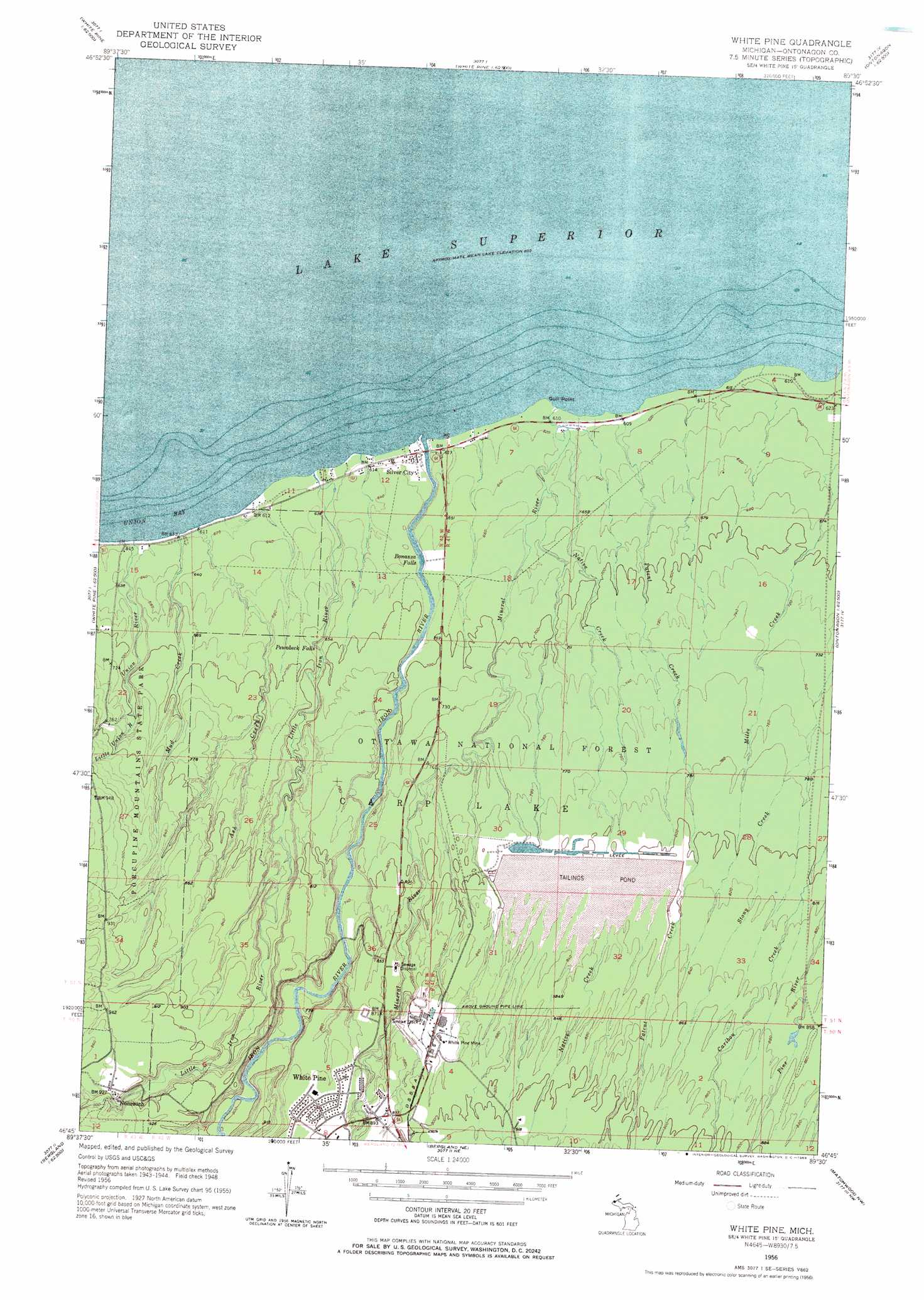
USGS Topo Quad 46089g5 - 1:24,000 scale
| Topo Map Name: | White Pine |
| USGS Topo Quad ID: | 46089g5 |
| Print Size: | ca. 21 1/4" wide x 27" high |
| Southeast Coordinates: | 46.75° N latitude / 89.5° W longitude |
| Map Center Coordinates: | 46.8125° N latitude / 89.5625° W longitude |
| U.S. State: | MI |
| Filename: | o46089g5.jpg |
| Download Map JPG Image: | White Pine topo map 1:24,000 scale |
| Map Type: | Topographic |
| Topo Series: | 7.5´ |
| Map Scale: | 1:24,000 |
| Source of Map Images: | United States Geological Survey (USGS) |
| Alternate Map Versions: |
White Pine MI 1949 Download PDF Buy paper map White Pine MI 1956, updated 1958 Download PDF Buy paper map White Pine MI 1956, updated 1969 Download PDF Buy paper map White Pine MI 2011 Download PDF Buy paper map White Pine MI 2014 Download PDF Buy paper map White Pine MI 2017 Download PDF Buy paper map |
1:24,000 Topo Quads surrounding White Pine
Ontonagon North |
||||
Carp River East |
Government Peak |
White Pine |
Green |
Ontonagon South |
Underwood Hill |
Aldridge Creek |
Bergland Ne |
Matchwood Nw |
Oak Bluff |
Tula |
Merriweather |
Bergland |
Matchwood |
Ewen |
> Back to 46089e1 at 1:100,000 scale
> Back to 46088a1 at 1:250,000 scale
> Back to U.S. Topo Maps home
White Pine topo map: Gazetteer
White Pine: Bays
Union Bay elevation 183m 600′White Pine: Capes
Gull Point elevation 183m 600′White Pine: Falls
Bonanza Falls elevation 202m 662′Little Union Gorge Falls elevation 211m 692′
Nonesuch Falls elevation 268m 879′
Pewabeck Falls elevation 203m 666′
White Pine: Mines
White Pine Mine elevation 266m 872′White Pine: Populated Places
Nonesuch elevation 282m 925′Silver City elevation 184m 603′
White Pine elevation 274m 898′
White Pine: Post Offices
Nonesuch Post Office (historical) elevation 283m 928′White Pine Post Office elevation 268m 879′
White Pine: Streams
Ash Creek elevation 184m 603′Big Iron River elevation 184m 603′
Little Iron River elevation 184m 603′
Little Union River elevation 214m 702′
Mineral River elevation 184m 603′
Mud Creek elevation 184m 603′
Native Creek elevation 189m 620′
Patent Creek elevation 183m 600′
Union River elevation 183m 600′
White Pine digital topo map on disk
Buy this White Pine topo map showing relief, roads, GPS coordinates and other geographical features, as a high-resolution digital map file on DVD: