Carp River East Topo Map Michigan
To zoom in, hover over the map of Carp River East
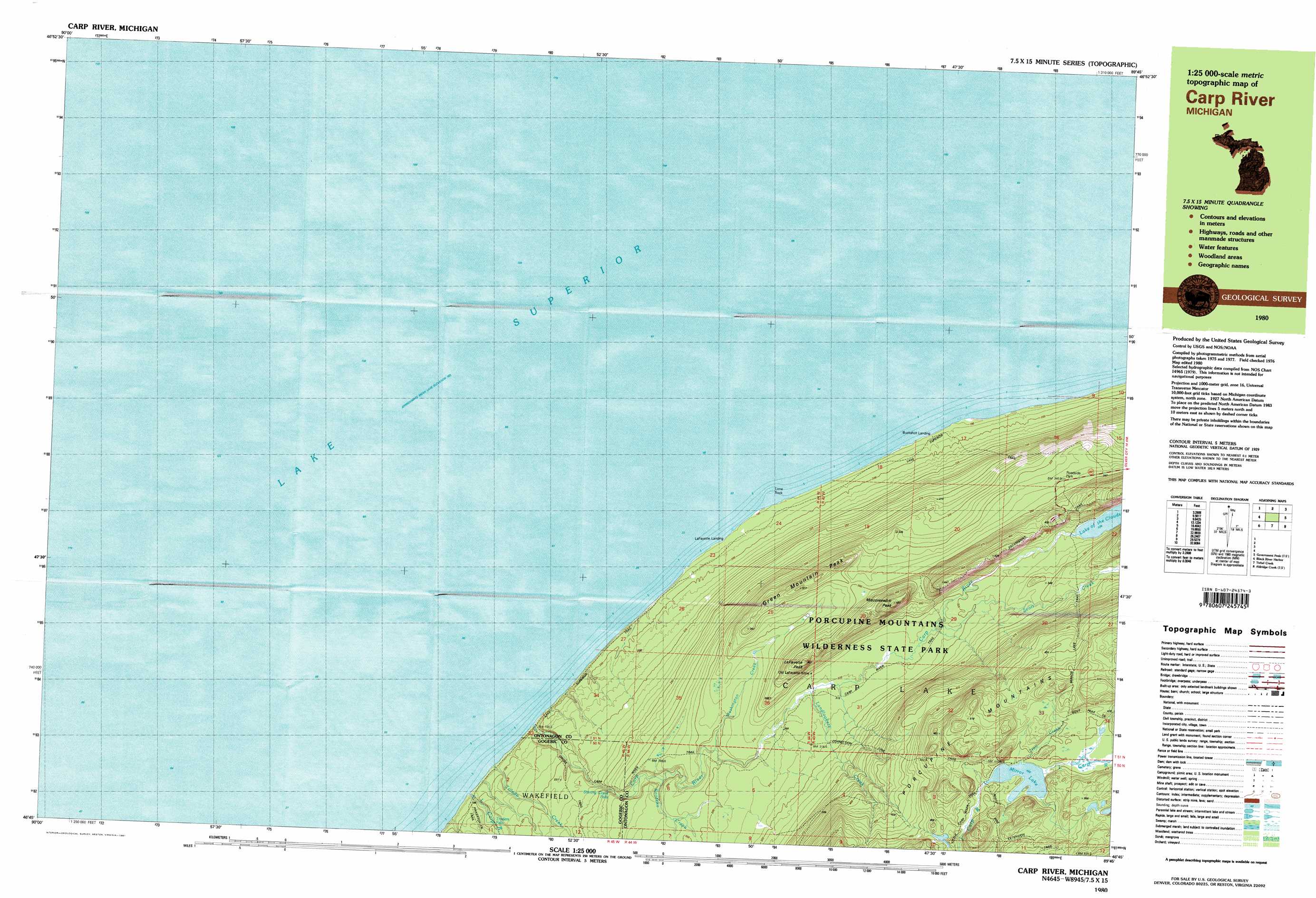
USGS Topo Quad 46089g7 - 1:25,000 scale
| Topo Map Name: | Carp River East |
| USGS Topo Quad ID: | 46089g7 |
| Print Size: | ca. 39" wide x 24" high |
| Southeast Coordinates: | 46.75° N latitude / 89.75° W longitude |
| Map Center Coordinates: | 46.8125° N latitude / 89.875° W longitude |
| U.S. State: | MI |
| Filename: | k46089g7.jpg |
| Download Map JPG Image: | Carp River East topo map 1:25,000 scale |
| Map Type: | Topographic |
| Topo Series: | 7.5´x15´ |
| Map Scale: | 1:25,000 |
| Source of Map Images: | United States Geological Survey (USGS) |
| Alternate Map Versions: |
Carp River MI 1980, updated 1981 Download PDF Buy paper map Carp River MI 1980, updated 1981 Download PDF Buy paper map Carp River MI 1994, updated 2000 Download PDF Buy paper map |
1:24,000 Topo Quads surrounding Carp River East
Carp River East |
Government Peak |
White Pine |
||
Black River Harbor |
Underwood Hill |
Aldridge Creek |
Bergland Ne |
|
Copper Peak |
Tula |
Merriweather |
Bergland |
> Back to 46089e1 at 1:100,000 scale
> Back to 46088a1 at 1:250,000 scale
> Back to U.S. Topo Maps home
Carp River East topo map: Gazetteer
Carp River East: Falls
Bathtub Falls elevation 203m 666′Big Carp Falls elevation 224m 734′
Shining Cloud Falls elevation 238m 780′
Traders Falls elevation 201m 659′
Carp River East: Lakes
Lake of the Clouds elevation 328m 1076′Mirror Lake elevation 466m 1528′
Carp River East: Mines
LaFayette Mine elevation 318m 1043′Carp River East: Pillars
Lone Rock elevation 183m 600′Carp River East: Populated Places
Buckshot Landing elevation 185m 606′LaFayette Landing elevation 186m 610′
Carp River East: Ranges
Porcupine Mountains elevation 472m 1548′Carp River East: Streams
Carp River elevation 183m 600′Konteka Creek elevation 269m 882′
Landlookers Creek elevation 310m 1017′
Little Carp River elevation 184m 603′
Scott Creek elevation 321m 1053′
Toledo Creek elevation 184m 603′
Trail Creek elevation 469m 1538′
Washington Creek elevation 289m 948′
Carp River East: Summits
Green Mountain Peak elevation 375m 1230′LaFayette Peak elevation 404m 1325′
Miscowawbic Peak elevation 438m 1437′
Carp River East digital topo map on disk
Buy this Carp River East topo map showing relief, roads, GPS coordinates and other geographical features, as a high-resolution digital map file on DVD: