Bayfield Topo Map Wisconsin
To zoom in, hover over the map of Bayfield
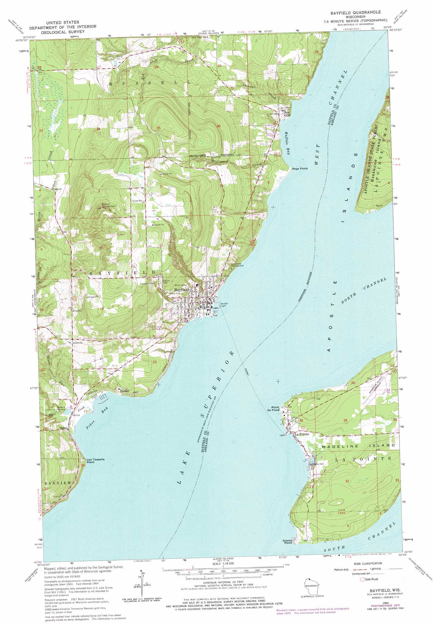
USGS Topo Quad 46090g7 - 1:24,000 scale
| Topo Map Name: | Bayfield |
| USGS Topo Quad ID: | 46090g7 |
| Print Size: | ca. 21 1/4" wide x 27" high |
| Southeast Coordinates: | 46.75° N latitude / 90.75° W longitude |
| Map Center Coordinates: | 46.8125° N latitude / 90.8125° W longitude |
| U.S. State: | WI |
| Filename: | o46090g7.jpg |
| Download Map JPG Image: | Bayfield topo map 1:24,000 scale |
| Map Type: | Topographic |
| Topo Series: | 7.5´ |
| Map Scale: | 1:24,000 |
| Source of Map Images: | United States Geological Survey (USGS) |
| Alternate Map Versions: |
Bayfield WI 1964, updated 1976 Download PDF Buy paper map Bayfield WI 1964, updated 1976 Download PDF Buy paper map Bayfield WI 2010 Download PDF Buy paper map Bayfield WI 2013 Download PDF Buy paper map Bayfield WI 2015 Download PDF Buy paper map |
1:24,000 Topo Quads surrounding Bayfield
Bear Island |
Rocky Island |
Cat Island |
||
Squaw Bay |
Sand Island |
York Island |
Oak Island |
Stockton Island |
Cornucopia |
Mount Ashwabay |
Bayfield |
Madeline Island |
Amnicon Point |
Mount Valhalla |
Washburn |
Long Island |
Chequamegon Point |
|
Moquah |
Ashland West |
Ashland East |
Odanah |
Cedar |
> Back to 46090e1 at 1:100,000 scale
> Back to 46090a1 at 1:250,000 scale
> Back to U.S. Topo Maps home
Bayfield topo map: Gazetteer
Bayfield: Airports
Madeline Island Airport elevation 196m 643′Bayfield: Bays
Buffalo Bay elevation 184m 603′Pikes Bay elevation 184m 603′
Bayfield: Capes
Grants Point elevation 184m 603′Point De Froid elevation 191m 626′
Roys Point elevation 184m 603′
Van Tassells Point elevation 194m 636′
Bayfield: Channels
West Channel elevation 184m 603′Bayfield: Mines
Bass Island Brownstone Company Quarry elevation 191m 626′Bayfield: Parks
Bayfield Historic District elevation 195m 639′Ojibwa Memorial Park elevation 184m 603′
Bayfield: Populated Places
Bayfield elevation 199m 652′La Pointe elevation 186m 610′
Middleport elevation 184m 603′
Old Fort elevation 189m 620′
Pureair elevation 198m 649′
Red Cliff elevation 195m 639′
Salmo elevation 189m 620′
Bayfield: Post Offices
Bayfield Post Office elevation 192m 629′La Pointe Post Office elevation 186m 610′
Bayfield: Streams
Birch Run elevation 184m 603′Brickyard Creek elevation 184m 603′
Chicago Creek elevation 192m 629′
Pikes Creek elevation 184m 603′
Bayfield digital topo map on disk
Buy this Bayfield topo map showing relief, roads, GPS coordinates and other geographical features, as a high-resolution digital map file on DVD: