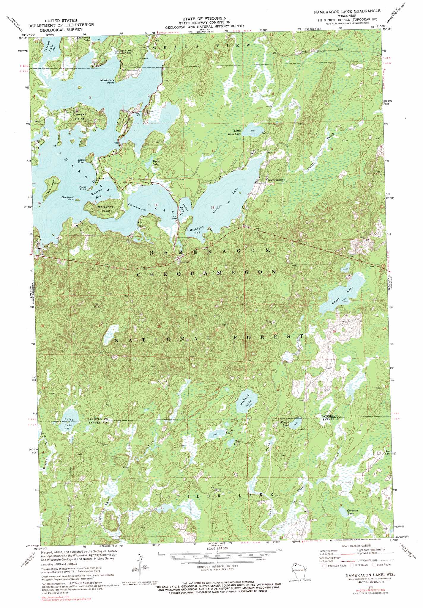
Namekagon Lake Topo Map Wisconsin
To zoom in, hover over the map of Namekagon Lake
USGS Topo Quad 46091b1 - 1:24,000 scale
| Topo Map Name: | Namekagon Lake |
| USGS Topo Quad ID: | 46091b1 |
| Print Size: | ca. 21 1/4" wide x 27" high |
| Southeast Coordinates: | 46.125° N latitude / 91° W longitude |
| Map Center Coordinates: | 46.1875° N latitude / 91.0625° W longitude |
| U.S. State: | WI |
| Filename: | o46091b1.jpg |
| Download Map JPG Image: | Namekagon Lake topo map 1:24,000 scale |
| Map Type: | Topographic |
| Topo Series: | 7.5´ |
| Map Scale: | 1:24,000 |
| Source of Map Images: | United States Geological Survey (USGS) |
| Alternate Map Versions: |
Namekagon Lake WI 1971, updated 1973 Download PDF Buy paper map Namekagon Lake WI 1971, updated 1990 Download PDF Buy paper map Namekagon Lake WI 2005, updated 2006 Download PDF Buy paper map Namekagon Lake WI 2011 Download PDF Buy paper map Namekagon Lake WI 2013 Download PDF Buy paper map Namekagon Lake WI 2015 Download PDF Buy paper map |
| FStopo: | US Forest Service topo Namekagon Lake is available: Download FStopo PDF Download FStopo TIF |
1:24,000 Topo Quads surrounding Namekagon Lake
Delta |
Grandview Nw |
Mason |
Sanborn |
Marengo |
Drummond |
Diamond Lake |
Grand View |
Marengo Lake |
Mineral Lake |
Cable |
Lake Tahkodah |
Namekagon Lake |
Clam Lake |
Clam Lake Ne |
Seeley |
Spider Lake |
Moose Lake |
Clam Lake Sw |
Clam Lake Se |
Chief Lake |
New Post |
Barker Lake |
Blaisdell Lake |
Loretta |
> Back to 46091a1 at 1:100,000 scale
> Back to 46090a1 at 1:250,000 scale
> Back to U.S. Topo Maps home
Namekagon Lake topo map: Gazetteer
Namekagon Lake: Bays
Janes Bay elevation 424m 1391′Michigan Bay elevation 424m 1391′
Mumms Bay elevation 424m 1391′
Namekagon Lake: Capes
Bergundy Point elevation 432m 1417′Eagle Point elevation 432m 1417′
Juneks Point elevation 435m 1427′
Missionary Point elevation 433m 1420′
Picnic Point elevation 423m 1387′
Namekagon Lake: Dams
Lynch Creek 5 G31.3 Dam elevation 436m 1430′Namekagon Lake: Forests
Chequamegon National Forest elevation 451m 1479′Namekagon Lake: Islands
Anderson Island elevation 434m 1423′Champaign Island elevation 424m 1391′
Paines Island elevation 432m 1417′
Namekagon Lake: Lakes
Cranberry Lake elevation 425m 1394′Evelyn Lake elevation 431m 1414′
Garden Lake elevation 424m 1391′
Ghost Lake elevation 442m 1450′
Goodwin Lake elevation 428m 1404′
Grant Lake elevation 436m 1430′
Hope Lake elevation 436m 1430′
Jackson Lake elevation 424m 1391′
Little Bass Lake elevation 428m 1404′
McCloud Lake elevation 439m 1440′
Namekagon Lake elevation 424m 1391′
Patsy Lake elevation 434m 1423′
Tank Lake elevation 422m 1384′
Namekagon Lake: Parks
Lynch Creek Number 5 Waterfowl Area elevation 427m 1400′Namekagon Lake Recreation Area elevation 431m 1414′
Namekagon Lake: Populated Places
Namekagon elevation 430m 1410′Namekagon Lake: Reservoirs
Lynch Creek Flowage elevation 436m 1430′Namekagon Lake: Streams
Castle Creek elevation 422m 1384′East Fork Ghost Creek elevation 429m 1407′
Taylor Creek elevation 420m 1377′
Namekagon Lake digital topo map on disk
Buy this Namekagon Lake topo map showing relief, roads, GPS coordinates and other geographical features, as a high-resolution digital map file on DVD: