Diamond Lake Topo Map Wisconsin
To zoom in, hover over the map of Diamond Lake
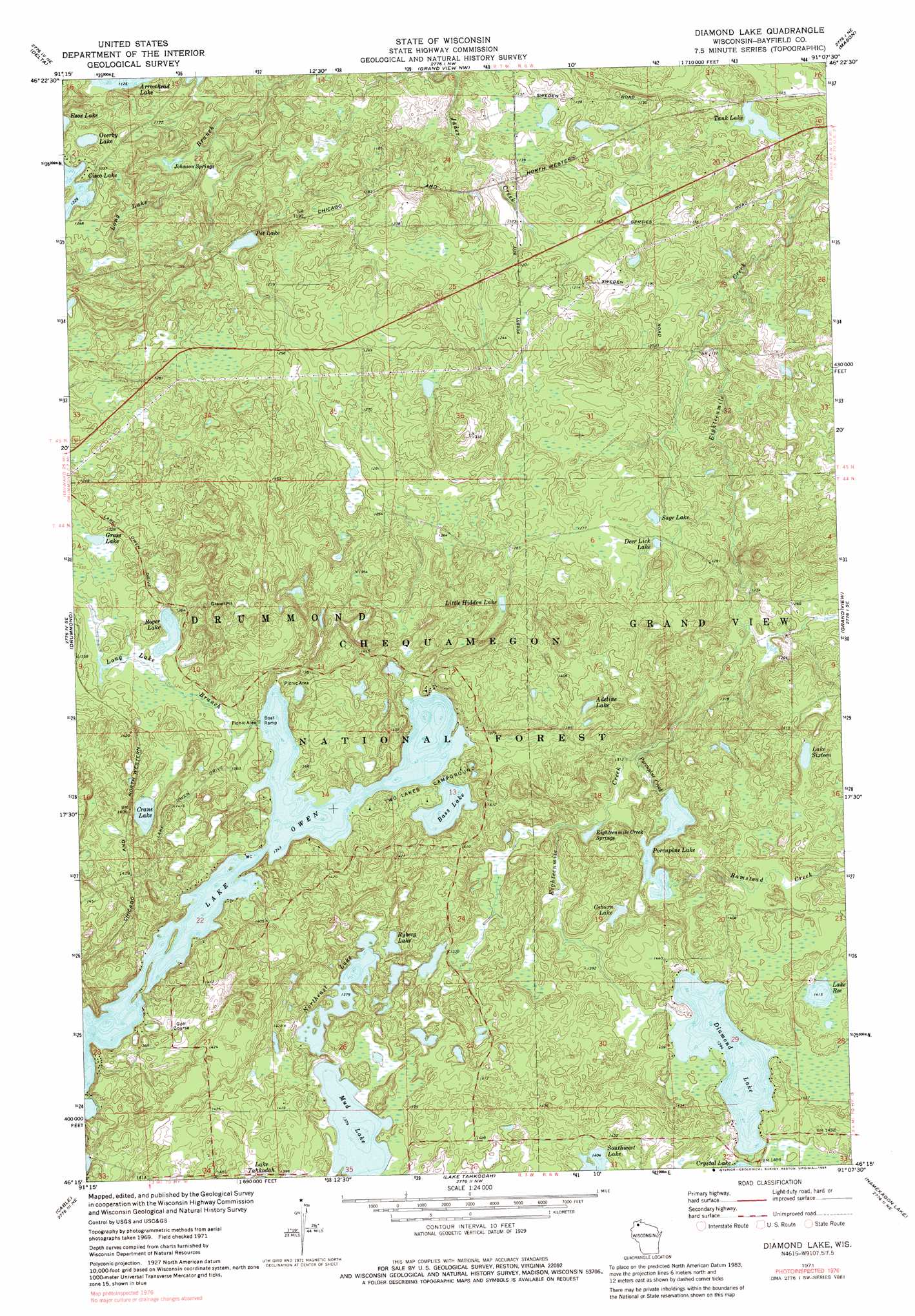
USGS Topo Quad 46091c2 - 1:24,000 scale
| Topo Map Name: | Diamond Lake |
| USGS Topo Quad ID: | 46091c2 |
| Print Size: | ca. 21 1/4" wide x 27" high |
| Southeast Coordinates: | 46.25° N latitude / 91.125° W longitude |
| Map Center Coordinates: | 46.3125° N latitude / 91.1875° W longitude |
| U.S. State: | WI |
| Filename: | o46091c2.jpg |
| Download Map JPG Image: | Diamond Lake topo map 1:24,000 scale |
| Map Type: | Topographic |
| Topo Series: | 7.5´ |
| Map Scale: | 1:24,000 |
| Source of Map Images: | United States Geological Survey (USGS) |
| Alternate Map Versions: |
Diamond Lake WI 1971, updated 1973 Download PDF Buy paper map Diamond Lake WI 1971, updated 1984 Download PDF Buy paper map Diamond Lake WI 1971, updated 1985 Download PDF Buy paper map Diamond Lake WI 2005, updated 2006 Download PDF Buy paper map Diamond Lake WI 2011 Download PDF Buy paper map Diamond Lake WI 2013 Download PDF Buy paper map Diamond Lake WI 2015 Download PDF Buy paper map |
| FStopo: | US Forest Service topo Diamond Lake is available: Download FStopo PDF Download FStopo TIF |
1:24,000 Topo Quads surrounding Diamond Lake
Iron Lake |
Hart Lake |
Ino |
Moquah |
Ashland West |
Drummond Nw |
Delta |
Grandview Nw |
Mason |
Sanborn |
Upper Eau Claire Lake |
Drummond |
Diamond Lake |
Grand View |
Marengo Lake |
Totagatic Lake |
Cable |
Lake Tahkodah |
Namekagon Lake |
Clam Lake |
Hayward |
Seeley |
Spider Lake |
Moose Lake |
Clam Lake Sw |
> Back to 46091a1 at 1:100,000 scale
> Back to 46090a1 at 1:250,000 scale
> Back to U.S. Topo Maps home
Diamond Lake topo map: Gazetteer
Diamond Lake: Dams
Johnson Springs 3WR211 Dam elevation 348m 1141′Lake Owen Dam elevation 409m 1341′
Diamond Lake: Lakes
Adeline Lake elevation 420m 1377′Arrowhead Lake elevation 343m 1125′
Bass Lake elevation 410m 1345′
Coburn Lake elevation 413m 1354′
Crane Lake elevation 416m 1364′
Deer Lick Lake elevation 387m 1269′
Diamond Lake elevation 425m 1394′
Grass Lake elevation 404m 1325′
Lake Owen elevation 409m 1341′
Lake Ree elevation 431m 1414′
Lake Sixteen elevation 432m 1417′
Little Hidden Lake elevation 401m 1315′
Northeast Lake elevation 420m 1377′
Overby Lake elevation 370m 1213′
Porcupine Lake elevation 407m 1335′
Pot Lake elevation 361m 1184′
Roger Lake elevation 404m 1325′
Ryberg Lake elevation 419m 1374′
Sage Lake elevation 383m 1256′
Southwest Lake elevation 428m 1404′
Sugar Bush Lake elevation 420m 1377′
Tank Lake elevation 331m 1085′
Diamond Lake: Reservoirs
Johnson Spring Flowage 1 elevation 348m 1141′Lake Owen 30 elevation 409m 1341′
Diamond Lake: Springs
Eighteenmile Creek Springs elevation 402m 1318′Johnson Springs elevation 343m 1125′
Diamond Lake: Streams
Porcupine Creek elevation 396m 1299′Ramstead Creek elevation 407m 1335′
Diamond Lake: Trails
North Country Trail elevation 429m 1407′Virgin Pine Trail elevation 380m 1246′
Diamond Lake digital topo map on disk
Buy this Diamond Lake topo map showing relief, roads, GPS coordinates and other geographical features, as a high-resolution digital map file on DVD: