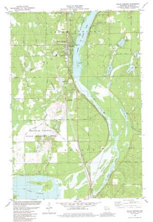
Solon Springs Topo Map Wisconsin
To zoom in, hover over the map of Solon Springs
USGS Topo Quad 46091c7 - 1:24,000 scale
| Topo Map Name: | Solon Springs |
| USGS Topo Quad ID: | 46091c7 |
| Print Size: | ca. 21 1/4" wide x 27" high |
| Southeast Coordinates: | 46.25° N latitude / 91.75° W longitude |
| Map Center Coordinates: | 46.3125° N latitude / 91.8125° W longitude |
| U.S. State: | WI |
| Filename: | o46091c7.jpg |
| Download Map JPG Image: | Solon Springs topo map 1:24,000 scale |
| Map Type: | Topographic |
| Topo Series: | 7.5´ |
| Map Scale: | 1:24,000 |
| Source of Map Images: | United States Geological Survey (USGS) |
| Alternate Map Versions: |
Solon Springs WI 1982, updated 1982 Download PDF Buy paper map Solon Springs WI 2010 Download PDF Buy paper map Solon Springs WI 2013 Download PDF Buy paper map Solon Springs WI 2015 Download PDF Buy paper map |
1:24,000 Topo Quads surrounding Solon Springs
> Back to 46091a1 at 1:100,000 scale
> Back to 46090a1 at 1:250,000 scale
> Back to U.S. Topo Maps home
Solon Springs topo map: Gazetteer
Solon Springs: Dams
Park Creek Pond G1997 2 Dam elevation 325m 1066′Smith G1997.5 Dam elevation 316m 1036′
Solon Springs: Islands
Crownhart Island elevation 309m 1013′Wilcox Island elevation 310m 1017′
Solon Springs: Lakes
Bass Lake elevation 329m 1079′Ferguson Lake elevation 351m 1151′
Island Lake elevation 326m 1069′
Long Lake elevation 326m 1069′
Lower Ox Lake elevation 308m 1010′
Muskrat Lake elevation 329m 1079′
Upper Saint Croix Lake elevation 309m 1013′
Solon Springs: Parks
Douglas County State Wildlife Area elevation 319m 1046′Lucius Woods State Park elevation 330m 1082′
Solon Springs: Populated Places
Sauntry elevation 348m 1141′Solon Springs elevation 332m 1089′
Solon Springs: Reservoirs
Olson Meadows Flowage elevation 316m 1036′Park Creek Pond elevation 325m 1066′
Park Creek Pond 3 elevation 327m 1072′
Solon Springs: Streams
Eau Claire River elevation 314m 1030′Leo Creek elevation 309m 1013′
Lower Ox Creek elevation 309m 1013′
Park Creek elevation 315m 1033′
Solon Springs digital topo map on disk
Buy this Solon Springs topo map showing relief, roads, GPS coordinates and other geographical features, as a high-resolution digital map file on DVD:


