Delta Topo Map Wisconsin
To zoom in, hover over the map of Delta
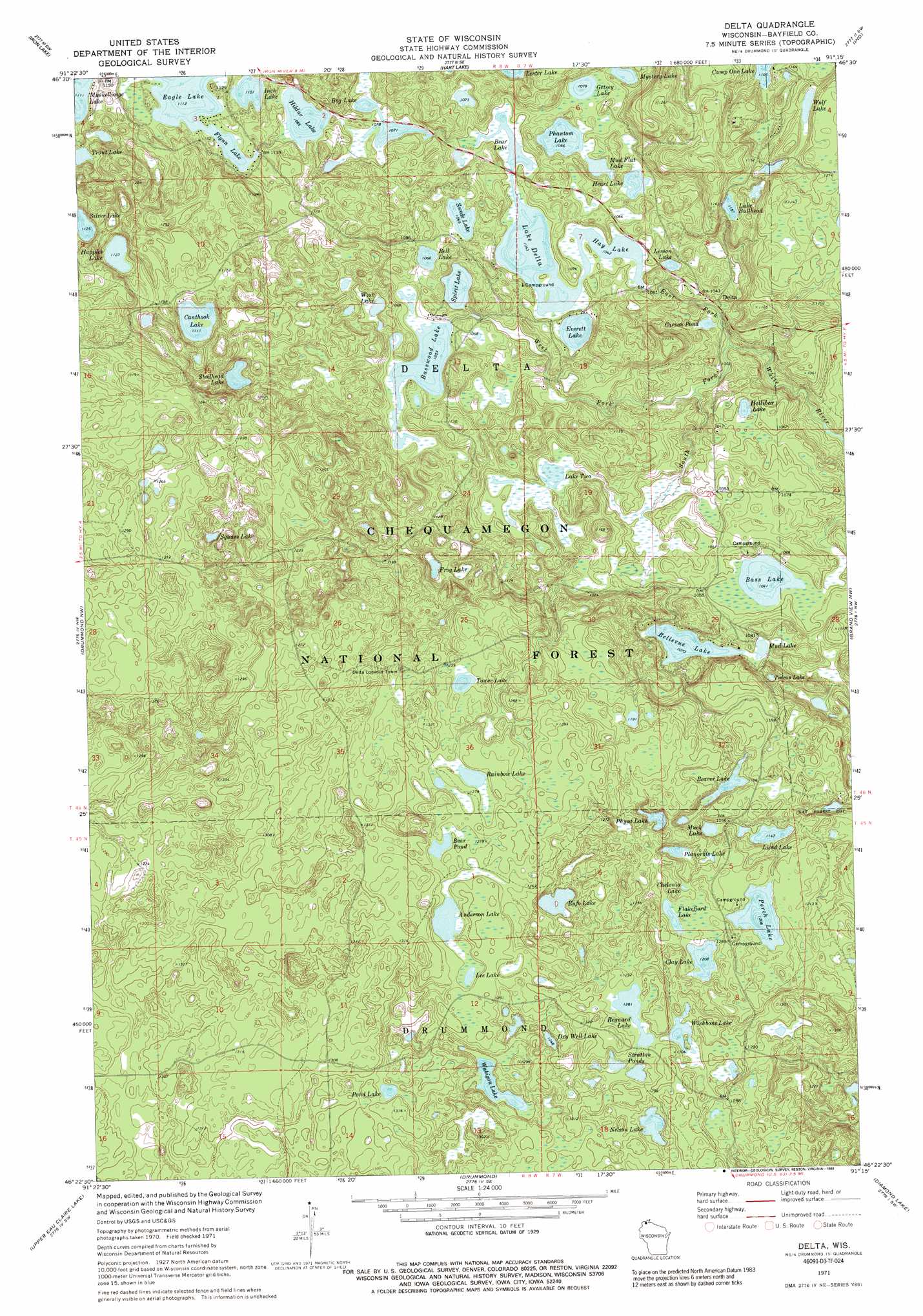
USGS Topo Quad 46091d3 - 1:24,000 scale
| Topo Map Name: | Delta |
| USGS Topo Quad ID: | 46091d3 |
| Print Size: | ca. 21 1/4" wide x 27" high |
| Southeast Coordinates: | 46.375° N latitude / 91.25° W longitude |
| Map Center Coordinates: | 46.4375° N latitude / 91.3125° W longitude |
| U.S. State: | WI |
| Filename: | o46091d3.jpg |
| Download Map JPG Image: | Delta topo map 1:24,000 scale |
| Map Type: | Topographic |
| Topo Series: | 7.5´ |
| Map Scale: | 1:24,000 |
| Source of Map Images: | United States Geological Survey (USGS) |
| Alternate Map Versions: |
Delta WI 1971, updated 1973 Download PDF Buy paper map Delta WI 1971, updated 1989 Download PDF Buy paper map Delta WI 2005, updated 2006 Download PDF Buy paper map Delta WI 2011 Download PDF Buy paper map Delta WI 2013 Download PDF Buy paper map Delta WI 2015 Download PDF Buy paper map |
| FStopo: | US Forest Service topo Delta is available: Download FStopo PDF Download FStopo TIF |
1:24,000 Topo Quads surrounding Delta
Oulu |
Blaine Creek |
Iron Lake Ne |
Moquah Nw |
Mount Valhalla |
Brule |
Iron Lake |
Hart Lake |
Ino |
Moquah |
Island Lake |
Drummond Nw |
Delta |
Grandview Nw |
Mason |
Ellison Lake |
Upper Eau Claire Lake |
Drummond |
Diamond Lake |
Grand View |
Chittamo Ne |
Totagatic Lake |
Cable |
Lake Tahkodah |
Namekagon Lake |
> Back to 46091a1 at 1:100,000 scale
> Back to 46090a1 at 1:250,000 scale
> Back to U.S. Topo Maps home
Delta topo map: Gazetteer
Delta: Dams
Murrays 2WP1034 Dam elevation 336m 1102′Delta: Lakes
Anderson Lake elevation 386m 1266′Bass Lake elevation 314m 1030′
Basswood Lake elevation 320m 1049′
Bear Lake elevation 317m 1040′
Bear Pond elevation 379m 1243′
Beaver Lake elevation 350m 1148′
Bell Lake elevation 323m 1059′
Bellevue Lake elevation 323m 1059′
Bog Lake elevation 324m 1062′
Bradox Lake elevation 358m 1174′
Broadax Lake elevation 351m 1151′
Bufo Lake elevation 364m 1194′
Canthook Lake elevation 338m 1108′
Carson Pond elevation 312m 1023′
Chelonia Lake elevation 372m 1220′
Clay Lake elevation 366m 1200′
Dry Well Lake elevation 372m 1220′
Eagle Lake elevation 337m 1105′
Everett Lake elevation 317m 1040′
Flakefjord Lake elevation 366m 1200′
Flynn Lake elevation 338m 1108′
Frog Lake elevation 321m 1053′
Getsey Lake elevation 326m 1069′
Happles Lake elevation 341m 1118′
Hay Lake elevation 317m 1040′
Heart Lake elevation 321m 1053′
Hildur Lake elevation 329m 1079′
Hollibar Lake elevation 306m 1003′
Inch Lake elevation 335m 1099′
Lake Bullhead elevation 341m 1118′
Lake Delta elevation 317m 1040′
Lake Two elevation 306m 1003′
Lee Lake elevation 382m 1253′
Lemon Lake elevation 316m 1036′
Lund Lake elevation 347m 1138′
Muck Lake elevation 345m 1131′
Mud Flat Lake elevation 317m 1040′
Mud Lake elevation 321m 1053′
Muskellunge Lake elevation 338m 1108′
Mystery Lake elevation 328m 1076′
Namagosh Lake elevation 313m 1026′
Nelson Lake elevation 378m 1240′
Perch Lake elevation 366m 1200′
Phantom Lake elevation 323m 1059′
Physa Lake elevation 352m 1154′
Planorbis Lake elevation 361m 1184′
Pond Lake elevation 382m 1253′
Rainbow Lake elevation 382m 1253′
Reynard Lake elevation 384m 1259′
Silver Lake elevation 343m 1125′
Spirit Lake elevation 317m 1040′
Square Lake elevation 365m 1197′
Steelhead Lake elevation 332m 1089′
Stratton Ponds elevation 386m 1266′
Swede Lake elevation 323m 1059′
Teacup Lake elevation 339m 1112′
Three Lake elevation 309m 1013′
Tower Lake elevation 374m 1227′
Wabigon Lake elevation 378m 1240′
West Lake elevation 324m 1062′
Wishbone Lake elevation 378m 1240′
Wolf Lake elevation 336m 1102′
Delta: Populated Places
Delta elevation 309m 1013′Delta: Reservoirs
Pike Lake Chain of Lakes 13 elevation 336m 1102′Delta: Streams
East Fork White River elevation 338m 1108′South Fork White River elevation 298m 977′
West Fork White River elevation 302m 990′
Delta digital topo map on disk
Buy this Delta topo map showing relief, roads, GPS coordinates and other geographical features, as a high-resolution digital map file on DVD: