Drummond Nw Topo Map Wisconsin
To zoom in, hover over the map of Drummond Nw
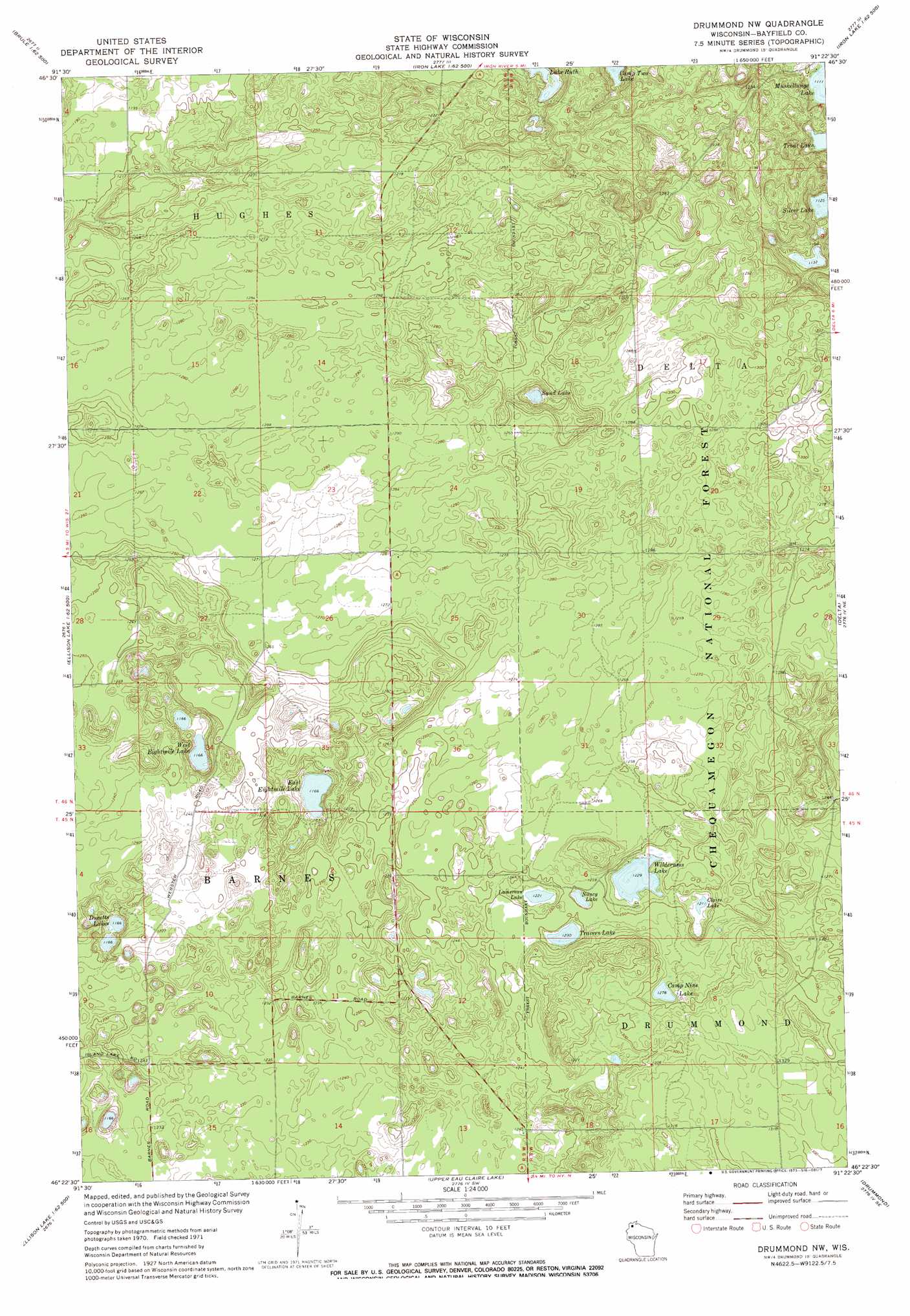
USGS Topo Quad 46091d4 - 1:24,000 scale
| Topo Map Name: | Drummond Nw |
| USGS Topo Quad ID: | 46091d4 |
| Print Size: | ca. 21 1/4" wide x 27" high |
| Southeast Coordinates: | 46.375° N latitude / 91.375° W longitude |
| Map Center Coordinates: | 46.4375° N latitude / 91.4375° W longitude |
| U.S. State: | WI |
| Filename: | o46091d4.jpg |
| Download Map JPG Image: | Drummond Nw topo map 1:24,000 scale |
| Map Type: | Topographic |
| Topo Series: | 7.5´ |
| Map Scale: | 1:24,000 |
| Source of Map Images: | United States Geological Survey (USGS) |
| Alternate Map Versions: |
Drummond NW WI 1971, updated 1973 Download PDF Buy paper map Drummond NW WI 1971, updated 1985 Download PDF Buy paper map Drummond NW WI 2005, updated 2006 Download PDF Buy paper map Drummond NW WI 2011 Download PDF Buy paper map Drummond NW WI 2013 Download PDF Buy paper map Drummond NW WI 2015 Download PDF Buy paper map |
| FStopo: | US Forest Service topo Drummond NW is available: Download FStopo PDF Download FStopo TIF |
1:24,000 Topo Quads surrounding Drummond Nw
Cloverland |
Oulu |
Blaine Creek |
Iron Lake Ne |
Moquah Nw |
Lake Nebagamon |
Brule |
Iron Lake |
Hart Lake |
Ino |
Lake Minnesuing |
Island Lake |
Drummond Nw |
Delta |
Grandview Nw |
Metzger Lake |
Ellison Lake |
Upper Eau Claire Lake |
Drummond |
Diamond Lake |
Chittamo |
Chittamo Ne |
Totagatic Lake |
Cable |
Lake Tahkodah |
> Back to 46091a1 at 1:100,000 scale
> Back to 46090a1 at 1:250,000 scale
> Back to U.S. Topo Maps home
Drummond Nw topo map: Gazetteer
Drummond Nw: Lakes
Camp Nine Lake elevation 390m 1279′Camp Two Lake elevation 346m 1135′
Claire Lake elevation 370m 1213′
Ducetts Lakes elevation 355m 1164′
East Eightmile Lake elevation 355m 1164′
Lamereau Lake elevation 372m 1220′
Nancy Lake elevation 376m 1233′
Sand Lake elevation 355m 1164′
Travers Lake elevation 375m 1230′
Trout Lake elevation 342m 1122′
West Eightmile Lake elevation 355m 1164′
Wilderness Lake elevation 375m 1230′
Drummond Nw digital topo map on disk
Buy this Drummond Nw topo map showing relief, roads, GPS coordinates and other geographical features, as a high-resolution digital map file on DVD: