Lyman Lake Topo Map Wisconsin
To zoom in, hover over the map of Lyman Lake
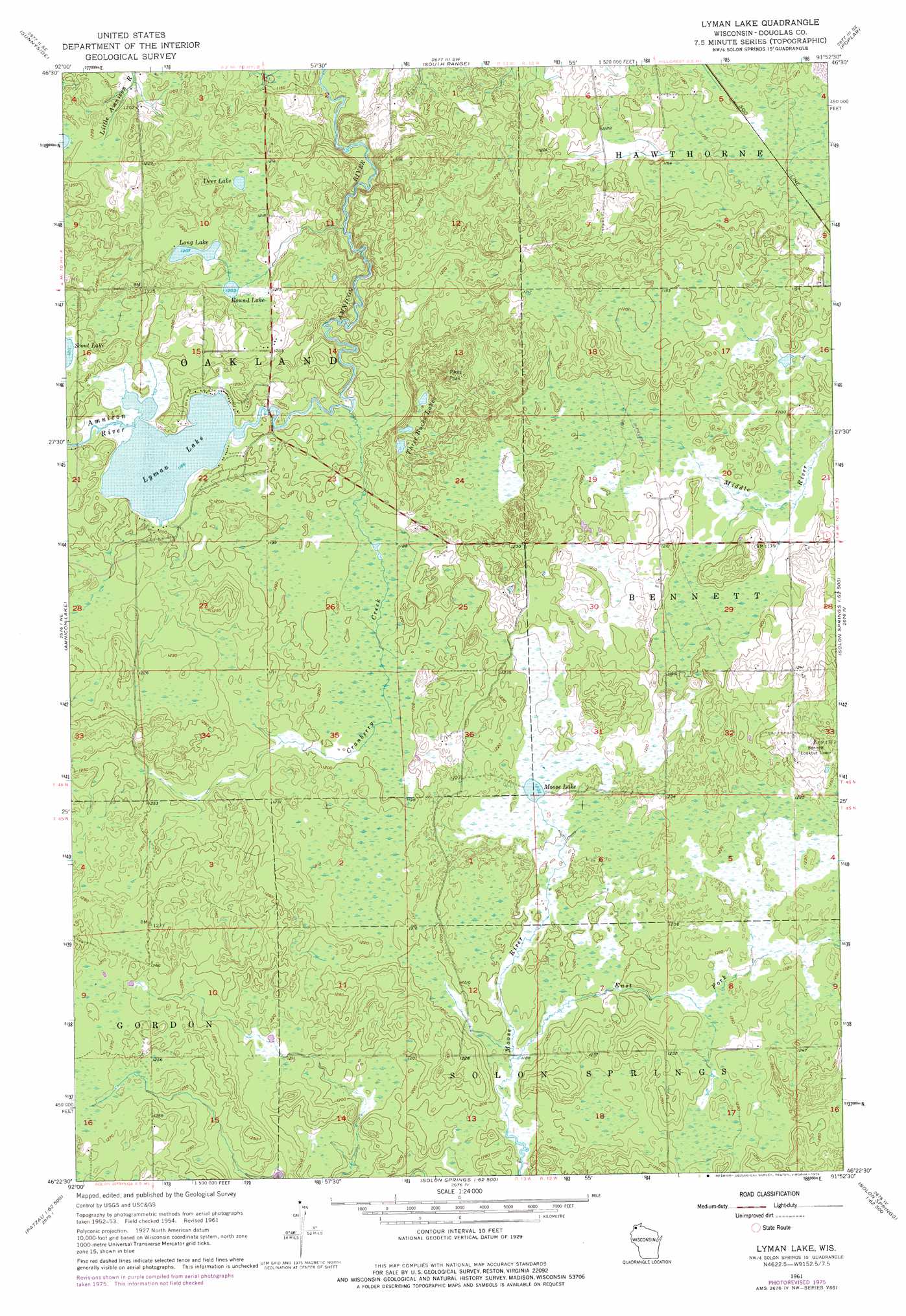
USGS Topo Quad 46091d8 - 1:24,000 scale
| Topo Map Name: | Lyman Lake |
| USGS Topo Quad ID: | 46091d8 |
| Print Size: | ca. 21 1/4" wide x 27" high |
| Southeast Coordinates: | 46.375° N latitude / 91.875° W longitude |
| Map Center Coordinates: | 46.4375° N latitude / 91.9375° W longitude |
| U.S. State: | WI |
| Filename: | o46091d8.jpg |
| Download Map JPG Image: | Lyman Lake topo map 1:24,000 scale |
| Map Type: | Topographic |
| Topo Series: | 7.5´ |
| Map Scale: | 1:24,000 |
| Source of Map Images: | United States Geological Survey (USGS) |
| Alternate Map Versions: |
Lyman Lake WI 1954, updated 1955 Download PDF Buy paper map Lyman Lake WI 1961, updated 1962 Download PDF Buy paper map Lyman Lake WI 1961, updated 1976 Download PDF Buy paper map Lyman Lake WI 2010 Download PDF Buy paper map Lyman Lake WI 2013 Download PDF Buy paper map Lyman Lake WI 2015 Download PDF Buy paper map |
1:24,000 Topo Quads surrounding Lyman Lake
West Duluth |
Superior |
Parkland |
Poplar Ne |
Cloverland |
Borea |
Sunnyside |
South Range |
Poplar |
Lake Nebagamon |
Patzau |
Amnicon Lake |
Lyman Lake |
Bennett |
Lake Minnesuing |
Moose Junction |
Empire Swamp |
Buckety Creek |
Solon Springs |
Metzger Lake |
Dairyland |
Scovils Lake |
Minong Flowage |
Gordon |
Chittamo |
> Back to 46091a1 at 1:100,000 scale
> Back to 46090a1 at 1:250,000 scale
> Back to U.S. Topo Maps home
Lyman Lake topo map: Gazetteer
Lyman Lake: Dams
Cranberry Creek Flowage 3WR402 Dam elevation 363m 1190′Lyman Lake: Lakes
Deer Lake elevation 371m 1217′Long Lake elevation 369m 1210′
Lyman Lake elevation 360m 1181′
Moose Lake elevation 366m 1200′
Round Lake elevation 366m 1200′
Three Bucks Lakes elevation 376m 1233′
Lyman Lake: Reservoirs
Cranberry Creek Flowage 8.3 elevation 363m 1190′Lyman Lake: Streams
Cranberry Creek elevation 360m 1181′Lyman Lake: Summits
Pikes Peak elevation 403m 1322′Lyman Lake digital topo map on disk
Buy this Lyman Lake topo map showing relief, roads, GPS coordinates and other geographical features, as a high-resolution digital map file on DVD: