Webb Lake Topo Map Wisconsin
To zoom in, hover over the map of Webb Lake
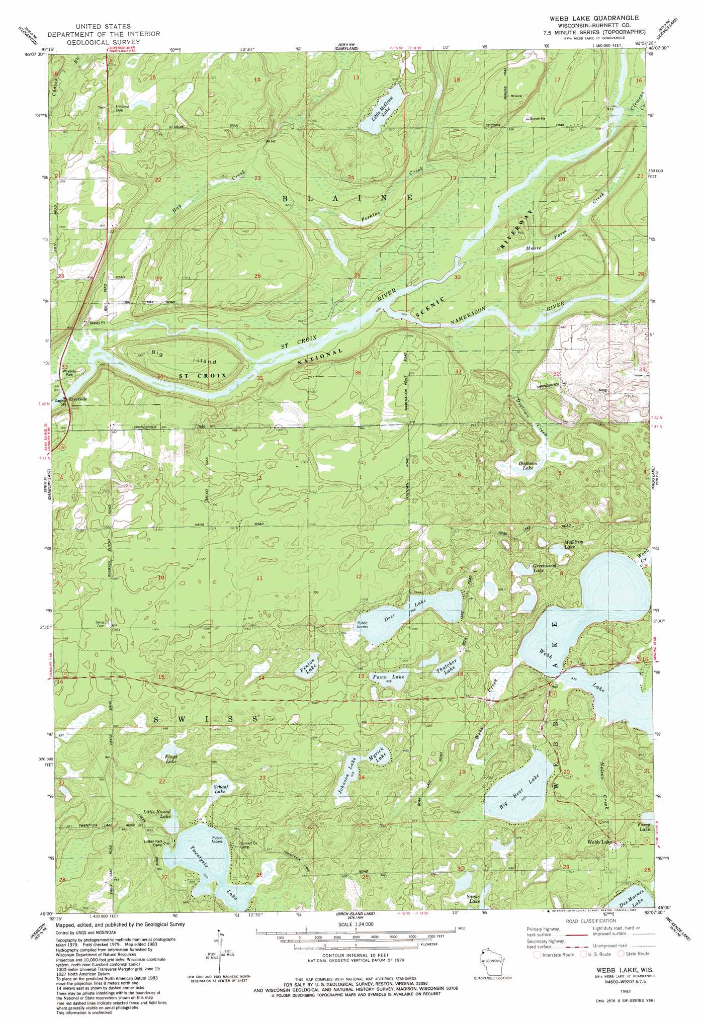
USGS Topo Quad 46092a2 - 1:24,000 scale
| Topo Map Name: | Webb Lake |
| USGS Topo Quad ID: | 46092a2 |
| Print Size: | ca. 21 1/4" wide x 27" high |
| Southeast Coordinates: | 46° N latitude / 92.125° W longitude |
| Map Center Coordinates: | 46.0625° N latitude / 92.1875° W longitude |
| U.S. State: | WI |
| Filename: | o46092a2.jpg |
| Download Map JPG Image: | Webb Lake topo map 1:24,000 scale |
| Map Type: | Topographic |
| Topo Series: | 7.5´ |
| Map Scale: | 1:24,000 |
| Source of Map Images: | United States Geological Survey (USGS) |
| Alternate Map Versions: |
Webb Lake WI 1983, updated 1983 Download PDF Buy paper map Webb Lake WI 2010 Download PDF Buy paper map Webb Lake WI 2013 Download PDF Buy paper map Webb Lake WI 2015 Download PDF Buy paper map |
1:24,000 Topo Quads surrounding Webb Lake
Holyoke Sw |
Black Lake |
Moose Junction |
Empire Swamp |
Buckety Creek |
Ox Creek |
Cloverton |
Dairyland |
Scovils Lake |
Minong Flowage |
Danbury West |
Danbury East |
Webb Lake |
Frog Lake |
Horseshoe Lake |
Yellow Lake |
Webster |
Birch Island Lake |
Mckenzie Lake |
Dunn Lake |
Siren West |
Siren East |
Hertel |
Poquettes Lake |
Spooner |
> Back to 46092a1 at 1:100,000 scale
> Back to 46092a1 at 1:250,000 scale
> Back to U.S. Topo Maps home
Webb Lake topo map: Gazetteer
Webb Lake: Islands
Big Island elevation 299m 980′Webb Lake: Lakes
Big Bear Lake elevation 290m 951′Deer Lake elevation 290m 951′
Dogtown Lake elevation 290m 951′
Fawn Lake elevation 290m 951′
Fenton Lake elevation 290m 951′
Floyd Lake elevation 290m 951′
Greenwood Lake elevation 287m 941′
Johnson Lake elevation 290m 951′
Little McGraw Lake elevation 302m 990′
Little Round Lake elevation 290m 951′
McElroy Lake elevation 285m 935′
Myrick Lake elevation 290m 951′
Schaaf Lake elevation 290m 951′
Thatcher Lake elevation 290m 951′
Twentysix Lake elevation 290m 951′
Webb Lake elevation 284m 931′
Webb Lake: Populated Places
Riverside elevation 272m 892′Webb Lake elevation 308m 1010′
Webb Lake: Streams
Clemens Creek elevation 275m 902′Dogtown Creek elevation 276m 905′
Glendenning Creek elevation 294m 964′
Hay Creek elevation 272m 892′
Moore Farm Creek elevation 274m 898′
Namekagon River elevation 272m 892′
Nelson Creek elevation 284m 931′
Perkins Creek elevation 273m 895′
Webb Lake digital topo map on disk
Buy this Webb Lake topo map showing relief, roads, GPS coordinates and other geographical features, as a high-resolution digital map file on DVD: