Cloverdale Topo Map Minnesota
To zoom in, hover over the map of Cloverdale
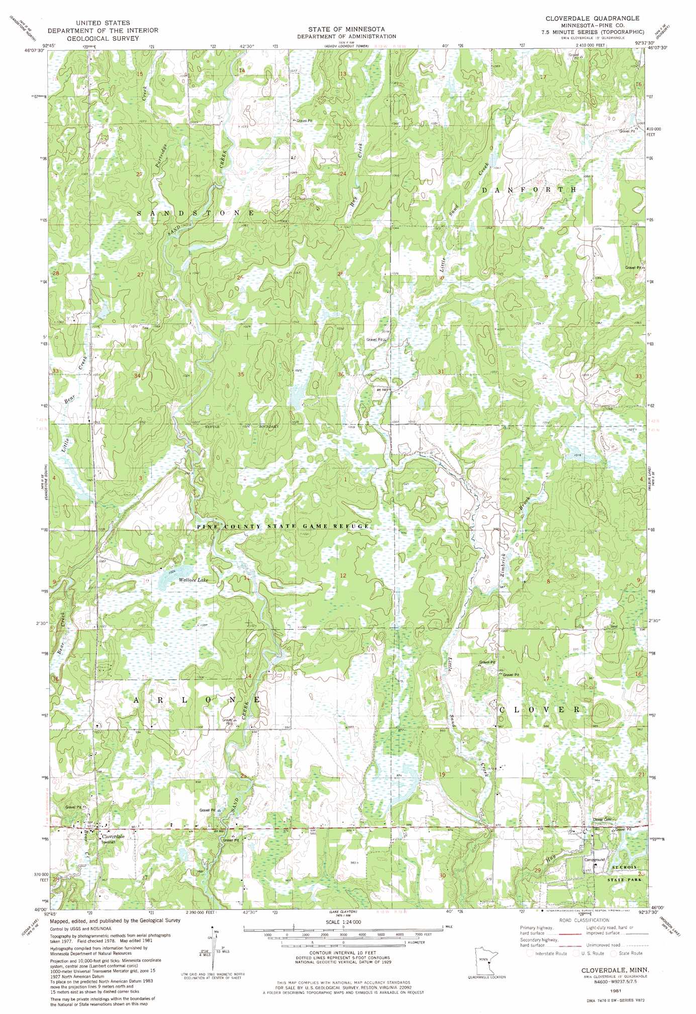
USGS Topo Quad 46092a6 - 1:24,000 scale
| Topo Map Name: | Cloverdale |
| USGS Topo Quad ID: | 46092a6 |
| Print Size: | ca. 21 1/4" wide x 27" high |
| Southeast Coordinates: | 46° N latitude / 92.625° W longitude |
| Map Center Coordinates: | 46.0625° N latitude / 92.6875° W longitude |
| U.S. State: | MN |
| Filename: | o46092a6.jpg |
| Download Map JPG Image: | Cloverdale topo map 1:24,000 scale |
| Map Type: | Topographic |
| Topo Series: | 7.5´ |
| Map Scale: | 1:24,000 |
| Source of Map Images: | United States Geological Survey (USGS) |
| Alternate Map Versions: |
Cloverdale MN 1981, updated 1982 Download PDF Buy paper map Cloverdale MN 2010 Download PDF Buy paper map Cloverdale MN 2013 Download PDF Buy paper map Cloverdale MN 2016 Download PDF Buy paper map |
1:24,000 Topo Quads surrounding Cloverdale
Denham |
Willow River |
Bruno |
Kerrick |
Holyoke Sw |
Finlayson |
Sandstone North |
Askov Lookout Tower |
Duxbury |
Ox Creek |
Hinckley |
Sandstone South |
Cloverdale |
Wilbur Lake |
Danbury West |
Beroun |
Cedar Lake |
Lake Clayton |
Saint Johns Landing |
Yellow Lake |
Pine City |
Bass Creek |
Grantsburg |
Falun |
Siren West |
> Back to 46092a1 at 1:100,000 scale
> Back to 46092a1 at 1:250,000 scale
> Back to U.S. Topo Maps home
Cloverdale topo map: Gazetteer
Cloverdale: Dams
Harmon Wetland Dam elevation 294m 964′Leonard Huer Wildlife Pond Dam elevation 290m 951′
Orville Harmon Dam elevation 294m 964′
Cloverdale: Lakes
Wallace Lake elevation 305m 1000′Cloverdale: Populated Places
Cloverdale elevation 298m 977′Cloverdale: Reservoirs
Harmon Pool elevation 294m 964′Orville Harmon Reservoir elevation 294m 964′
Cloverdale: Streams
Hay Creek elevation 306m 1003′Little Bear Creek elevation 301m 987′
Partridge Creek elevation 315m 1033′
Zimbrick Brook elevation 296m 971′
Cloverdale digital topo map on disk
Buy this Cloverdale topo map showing relief, roads, GPS coordinates and other geographical features, as a high-resolution digital map file on DVD: