Sandstone North Topo Map Minnesota
To zoom in, hover over the map of Sandstone North
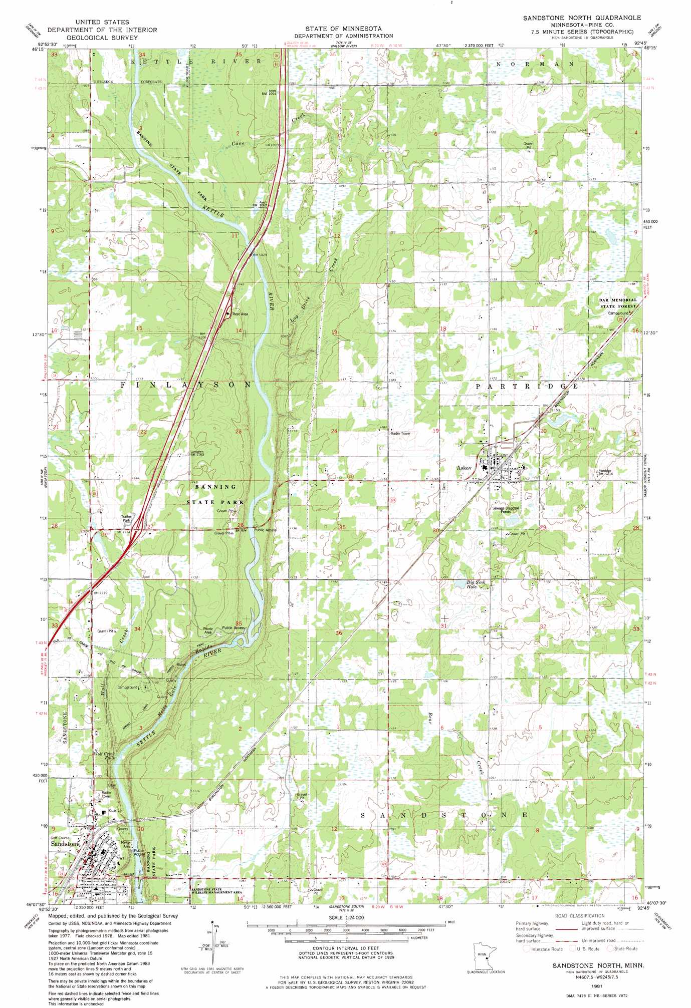
USGS Topo Quad 46092b7 - 1:24,000 scale
| Topo Map Name: | Sandstone North |
| USGS Topo Quad ID: | 46092b7 |
| Print Size: | ca. 21 1/4" wide x 27" high |
| Southeast Coordinates: | 46.125° N latitude / 92.75° W longitude |
| Map Center Coordinates: | 46.1875° N latitude / 92.8125° W longitude |
| U.S. State: | MN |
| Filename: | o46092b7.jpg |
| Download Map JPG Image: | Sandstone North topo map 1:24,000 scale |
| Map Type: | Topographic |
| Topo Series: | 7.5´ |
| Map Scale: | 1:24,000 |
| Source of Map Images: | United States Geological Survey (USGS) |
| Alternate Map Versions: |
Sandstone North MN 1981, updated 1982 Download PDF Buy paper map Sandstone North MN 2010 Download PDF Buy paper map Sandstone North MN 2013 Download PDF Buy paper map Sandstone North MN 2016 Download PDF Buy paper map |
1:24,000 Topo Quads surrounding Sandstone North
Ronald |
Kettle River |
Moose Lake |
Hanging Horn Lake |
Nickerson |
Arthyde |
Denham |
Willow River |
Bruno |
Kerrick |
Giese |
Finlayson |
Sandstone North |
Askov Lookout Tower |
Duxbury |
Kroschel |
Hinckley |
Sandstone South |
Cloverdale |
Wilbur Lake |
Brook Park |
Beroun |
Cedar Lake |
Lake Clayton |
Saint Johns Landing |
> Back to 46092a1 at 1:100,000 scale
> Back to 46092a1 at 1:250,000 scale
> Back to U.S. Topo Maps home
Sandstone North topo map: Gazetteer
Sandstone North: Crossings
Interchange 195 elevation 345m 1131′Sandstone North: Falls
Wolf Creek Falls elevation 295m 967′Sandstone North: Lakes
Big Sink Hole elevation 340m 1115′Sandstone North: Parks
Banning State Park elevation 342m 1122′Johnson Park elevation 332m 1089′
Kettle River Rapids Geological Marker elevation 340m 1115′
Lumbering in Minnesota Historical Marker elevation 326m 1069′
Military Road Historical Marker elevation 340m 1115′
Railroad Park elevation 332m 1089′
Robinson Park elevation 297m 974′
Watertower Park elevation 310m 1017′
Sandstone North: Populated Places
Askov elevation 356m 1167′Banning elevation 339m 1112′
Johnson's Sunset Mobile Home Park elevation 336m 1102′
Sandstone elevation 332m 1089′
Sandstone North: Post Offices
Askov Post Office elevation 354m 1161′Sandstone Post Office elevation 332m 1089′
Sandstone North: Rapids
Hells Gate Rapids elevation 298m 977′Quarry Rapids elevation 292m 958′
Sandstone North: Streams
Cane Creek elevation 306m 1003′Log Drive Creek elevation 307m 1007′
Wolf Creek elevation 294m 964′
Sandstone North: Trails
Cartway Trail elevation 336m 1102′Cut-off Trail elevation 336m 1102′
Deadman Trail elevation 336m 1102′
Hells Gate Trail elevation 336m 1102′
High Bluff Trail elevation 336m 1102′
Lower Hell's Gate Trail elevation 336m 1102′
Quarry Loop Trail elevation 336m 1102′
Skunk Cabbage Trail elevation 336m 1102′
Spur Trail elevation 336m 1102′
Township Trail elevation 336m 1102′
Trillium Trail elevation 336m 1102′
Wolf Creek Trail elevation 336m 1102′
Sandstone North digital topo map on disk
Buy this Sandstone North topo map showing relief, roads, GPS coordinates and other geographical features, as a high-resolution digital map file on DVD: