Patzau Topo Map Wisconsin
To zoom in, hover over the map of Patzau
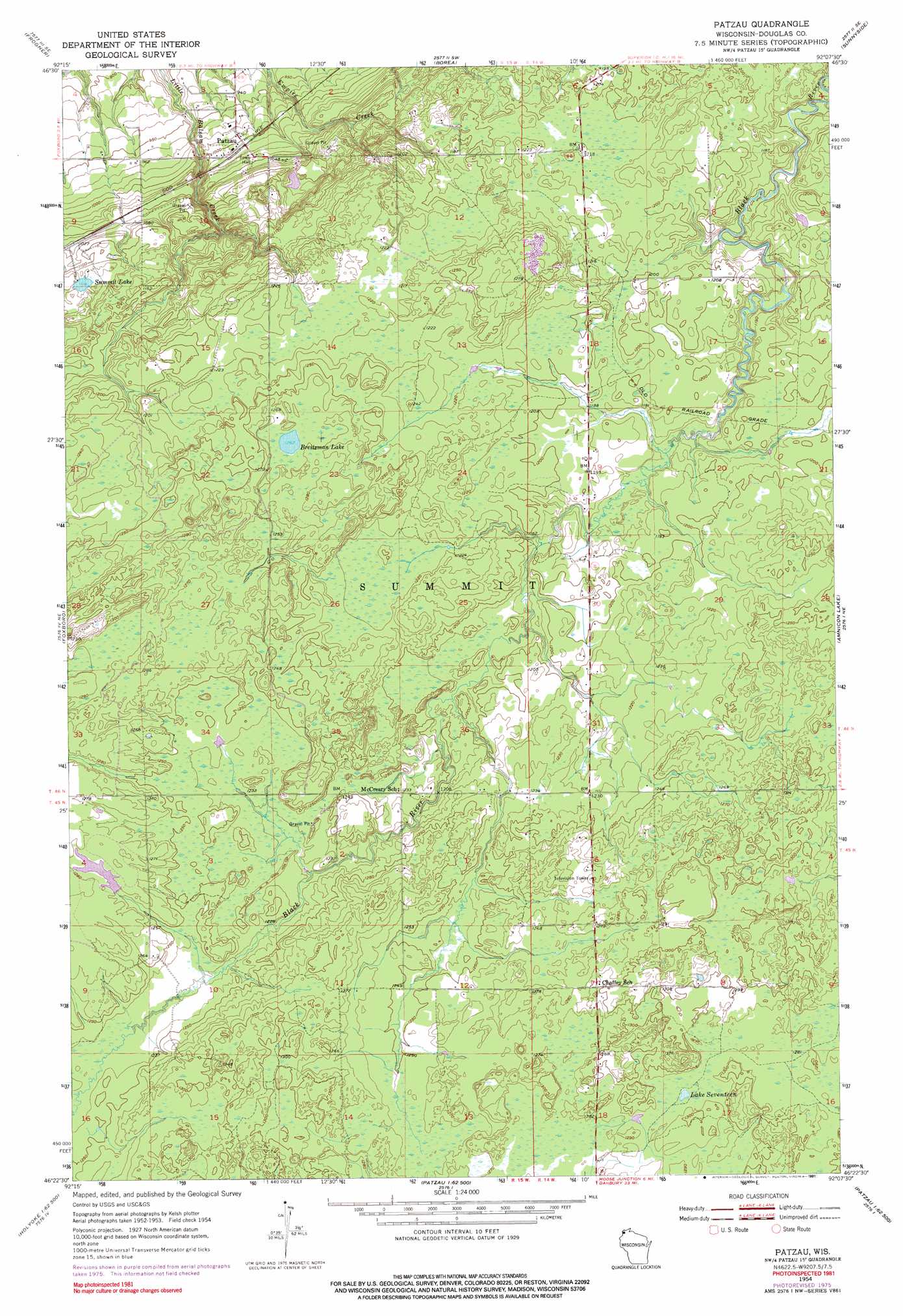
USGS Topo Quad 46092d2 - 1:24,000 scale
| Topo Map Name: | Patzau |
| USGS Topo Quad ID: | 46092d2 |
| Print Size: | ca. 21 1/4" wide x 27" high |
| Southeast Coordinates: | 46.375° N latitude / 92.125° W longitude |
| Map Center Coordinates: | 46.4375° N latitude / 92.1875° W longitude |
| U.S. State: | WI |
| Filename: | o46092d2.jpg |
| Download Map JPG Image: | Patzau topo map 1:24,000 scale |
| Map Type: | Topographic |
| Topo Series: | 7.5´ |
| Map Scale: | 1:24,000 |
| Source of Map Images: | United States Geological Survey (USGS) |
| Alternate Map Versions: |
Patzau WI 1954, updated 1955 Download PDF Buy paper map Patzau WI 1954, updated 1974 Download PDF Buy paper map Patzau WI 1954, updated 1976 Download PDF Buy paper map Patzau WI 1954, updated 1991 Download PDF Buy paper map Patzau WI 2010 Download PDF Buy paper map Patzau WI 2013 Download PDF Buy paper map Patzau WI 2015 Download PDF Buy paper map |
1:24,000 Topo Quads surrounding Patzau
Cloquet |
Esko |
West Duluth |
Superior |
Parkland |
Wrenshall |
Frogner |
Borea |
Sunnyside |
South Range |
Holyoke |
Foxboro |
Patzau |
Amnicon Lake |
Lyman Lake |
Holyoke Sw |
Black Lake |
Moose Junction |
Empire Swamp |
Buckety Creek |
Ox Creek |
Cloverton |
Dairyland |
Scovils Lake |
Minong Flowage |
> Back to 46092a1 at 1:100,000 scale
> Back to 46092a1 at 1:250,000 scale
> Back to U.S. Topo Maps home
Patzau topo map: Gazetteer
Patzau: Lakes
Breitzman Lake elevation 384m 1259′Lake Seventeen elevation 392m 1286′
Summit Lake elevation 341m 1118′
Patzau: Populated Places
Chaffey elevation 390m 1279′Patzau elevation 307m 1007′
Patzau digital topo map on disk
Buy this Patzau topo map showing relief, roads, GPS coordinates and other geographical features, as a high-resolution digital map file on DVD: