Holyoke Topo Map Minnesota
To zoom in, hover over the map of Holyoke
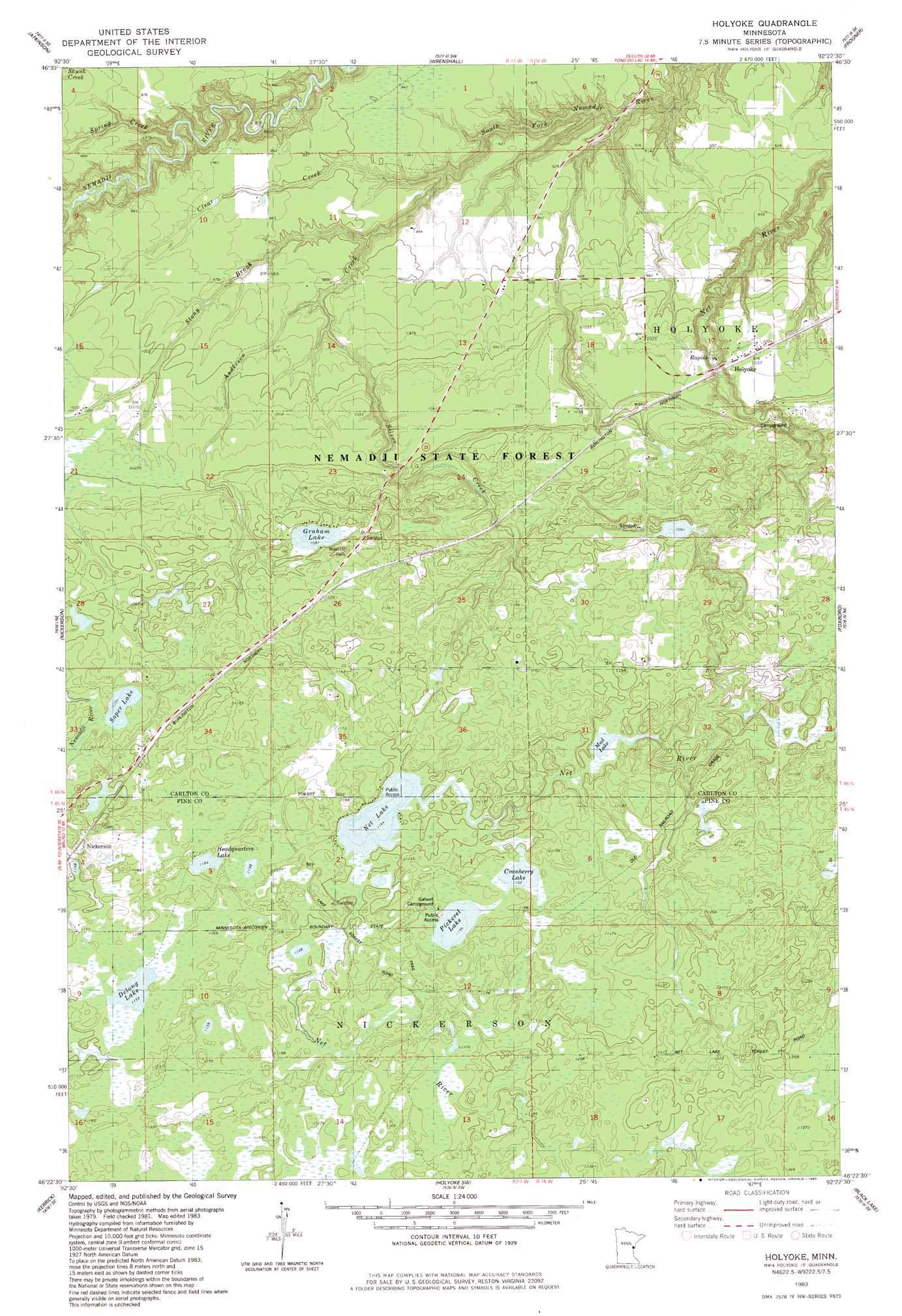
USGS Topo Quad 46092d4 - 1:24,000 scale
| Topo Map Name: | Holyoke |
| USGS Topo Quad ID: | 46092d4 |
| Print Size: | ca. 21 1/4" wide x 27" high |
| Southeast Coordinates: | 46.375° N latitude / 92.375° W longitude |
| Map Center Coordinates: | 46.4375° N latitude / 92.4375° W longitude |
| U.S. State: | MN |
| Filename: | o46092d4.jpg |
| Download Map JPG Image: | Holyoke topo map 1:24,000 scale |
| Map Type: | Topographic |
| Topo Series: | 7.5´ |
| Map Scale: | 1:24,000 |
| Source of Map Images: | United States Geological Survey (USGS) |
| Alternate Map Versions: |
Holyoke MN 1983, updated 1983 Download PDF Buy paper map Holyoke MN 2010 Download PDF Buy paper map Holyoke MN 2013 Download PDF Buy paper map Holyoke MN 2016 Download PDF Buy paper map |
1:24,000 Topo Quads surrounding Holyoke
Sawyer |
Iverson |
Cloquet |
Esko |
West Duluth |
Barnum |
Atkinson |
Wrenshall |
Frogner |
Borea |
Hanging Horn Lake |
Nickerson |
Holyoke |
Foxboro |
Patzau |
Bruno |
Kerrick |
Holyoke Sw |
Black Lake |
Moose Junction |
Askov Lookout Tower |
Duxbury |
Ox Creek |
Cloverton |
Dairyland |
> Back to 46092a1 at 1:100,000 scale
> Back to 46092a1 at 1:250,000 scale
> Back to U.S. Topo Maps home
Holyoke topo map: Gazetteer
Holyoke: Dams
Herman Mader Pond Dam elevation 332m 1089′Holyoke: Lakes
Cranberry Lake elevation 351m 1151′Delong Lake elevation 351m 1151′
Graham Lake elevation 330m 1082′
Headquarters Lake elevation 354m 1161′
Mud Lake elevation 345m 1131′
Net Lake elevation 348m 1141′
Pickerel Lake elevation 351m 1151′
Soper Lake elevation 335m 1099′
Holyoke: Parks
Graham Lake Wayside Park elevation 339m 1112′Holyoke: Populated Places
Holyoke elevation 315m 1033′Nickerson elevation 351m 1151′
Holyoke: Post Offices
Holyoke Post Office elevation 315m 1033′Holyoke: Streams
Anderson Creek elevation 272m 892′Clear Creek elevation 265m 869′
Nemadji Creek elevation 269m 882′
Silver Creek elevation 291m 954′
Stony Brook elevation 265m 869′
Holyoke digital topo map on disk
Buy this Holyoke topo map showing relief, roads, GPS coordinates and other geographical features, as a high-resolution digital map file on DVD: