West Duluth Topo Map Wisconsin
To zoom in, hover over the map of West Duluth
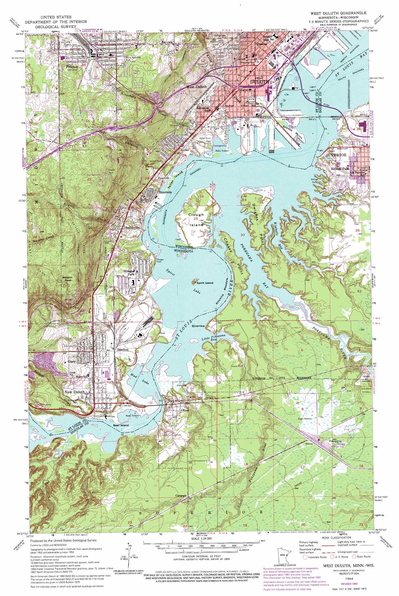
USGS Topo Quad 46092f2 - 1:24,000 scale
| Topo Map Name: | West Duluth |
| USGS Topo Quad ID: | 46092f2 |
| Print Size: | ca. 21 1/4" wide x 27" high |
| Southeast Coordinates: | 46.625° N latitude / 92.125° W longitude |
| Map Center Coordinates: | 46.6875° N latitude / 92.1875° W longitude |
| U.S. States: | WI, MN |
| Filename: | o46092f2.jpg |
| Download Map JPG Image: | West Duluth topo map 1:24,000 scale |
| Map Type: | Topographic |
| Topo Series: | 7.5´ |
| Map Scale: | 1:24,000 |
| Source of Map Images: | United States Geological Survey (USGS) |
| Alternate Map Versions: |
West Duluth MN 1954, updated 1955 Download PDF Buy paper map West Duluth MN 1954, updated 1955 Download PDF Buy paper map West Duluth MN 1954, updated 1955 Download PDF Buy paper map West Duluth MN 1954, updated 1970 Download PDF Buy paper map West Duluth MN 1954, updated 1977 Download PDF Buy paper map West Duluth MN 1954, updated 1977 Download PDF Buy paper map West Duluth MN 1954, updated 1982 Download PDF Buy paper map West Duluth MN 1954, updated 1983 Download PDF Buy paper map West Duluth MN 1954, updated 1993 Download PDF Buy paper map West Duluth MN 1997, updated 1999 Download PDF Buy paper map West Duluth MN 2010 Download PDF Buy paper map West Duluth MN 2013 Download PDF Buy paper map West Duluth MN 2016 Download PDF Buy paper map |
1:24,000 Topo Quads surrounding West Duluth
Independence |
Twig |
Fredenberg |
Arnold |
French River |
Saginaw |
Adolph |
Duluth Heights |
Duluth |
Lakewood |
Cloquet |
Esko |
West Duluth |
Superior |
Parkland |
Wrenshall |
Frogner |
Borea |
Sunnyside |
South Range |
Holyoke |
Foxboro |
Patzau |
Amnicon Lake |
Lyman Lake |
> Back to 46092e1 at 1:100,000 scale
> Back to 46092a1 at 1:250,000 scale
> Back to U.S. Topo Maps home
West Duluth topo map: Gazetteer
West Duluth: Bays
Kimballs Bay elevation 184m 603′Little Pokegama Bay elevation 184m 603′
Pokegama Bay elevation 184m 603′
West Duluth: Bridges
Arrowhead Bridge elevation 184m 603′Arrowhead Bridge elevation 184m 603′
Bong Bridge elevation 184m 603′
Old Oliver Bridge elevation 184m 603′
West Duluth: Capes
Chases Point elevation 188m 616′Dwights Point elevation 197m 646′
Grassy Point elevation 184m 603′
West Duluth: Channels
Minnesota Channel elevation 184m 603′West Duluth: Islands
Bear Island elevation 184m 603′Clough Island elevation 194m 636′
Kilchlis Meadow elevation 184m 603′
Spirit Island elevation 196m 643′
Tallas Island elevation 184m 603′
West Duluth: Lakes
Mud Lake elevation 184m 603′Spirit Lake elevation 184m 603′
West Duluth: Parks
Billings Park elevation 194m 636′Birchwood Park elevation 189m 620′
Fairmount Park elevation 204m 669′
Gasser Park elevation 381m 1250′
Geology of Duluth Harbor Geological Marker elevation 295m 967′
Indian Park elevation 365m 1197′
Indian Point Park elevation 184m 603′
Irving Playfield elevation 189m 620′
Klang Memorial Park elevation 371m 1217′
Minnesotas Seaport Historical Marker elevation 295m 967′
Morgan Park elevation 186m 610′
New Duluth Scenic Overlook elevation 185m 606′
Norton Park elevation 191m 626′
Snively Park elevation 344m 1128′
West Duluth: Populated Places
Bayview elevation 364m 1194′Carnegie elevation 225m 738′
Gary elevation 208m 682′
Morgan Park elevation 201m 659′
New Duluth elevation 204m 669′
Oliver elevation 197m 646′
Oneota elevation 204m 669′
Pleasant View Mobile Home Park elevation 211m 692′
Pokegama elevation 209m 685′
Proctor elevation 381m 1250′
Riverside elevation 197m 646′
Riverview elevation 190m 623′
Smithville elevation 214m 702′
Steelton elevation 203m 666′
West Duluth elevation 224m 734′
Zenith Terrace elevation 369m 1210′
West Duluth: Post Offices
New Duluth Post Office (historical) elevation 204m 669′Oneota Post Office (historical) elevation 204m 669′
Proctor Post Office (historical) elevation 377m 1236′
Smithville Post Office (historical) elevation 217m 711′
West Duluth Post Office (historical) elevation 221m 725′
West Duluth: Streams
Keene Creek elevation 184m 603′Kingsbury Creek elevation 186m 610′
Knowlton Creek elevation 184m 603′
Little Pokegama River elevation 184m 603′
Pokegama River elevation 184m 603′
Red River elevation 184m 603′
Red River elevation 184m 603′
Saint Louis River elevation 184m 603′
Sargent Creek elevation 184m 603′
Stewart Creek elevation 184m 603′
West Duluth: Summits
Bardon Peak elevation 379m 1243′West Duluth digital topo map on disk
Buy this West Duluth topo map showing relief, roads, GPS coordinates and other geographical features, as a high-resolution digital map file on DVD: