Sawyer Topo Map Minnesota
To zoom in, hover over the map of Sawyer
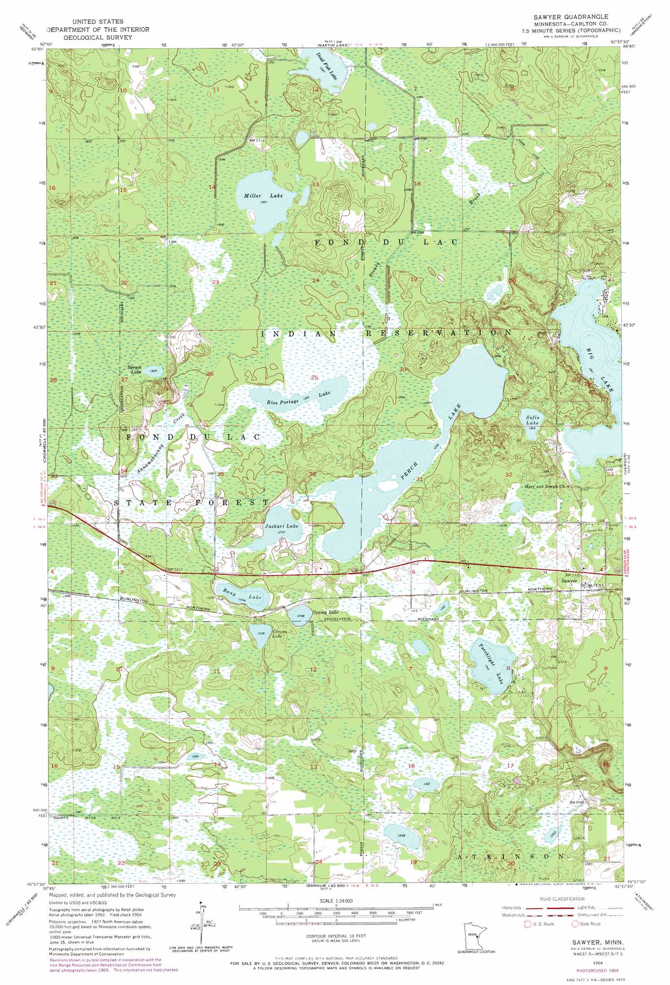
USGS Topo Quad 46092f6 - 1:24,000 scale
| Topo Map Name: | Sawyer |
| USGS Topo Quad ID: | 46092f6 |
| Print Size: | ca. 21 1/4" wide x 27" high |
| Southeast Coordinates: | 46.625° N latitude / 92.625° W longitude |
| Map Center Coordinates: | 46.6875° N latitude / 92.6875° W longitude |
| U.S. State: | MN |
| Filename: | o46092f6.jpg |
| Download Map JPG Image: | Sawyer topo map 1:24,000 scale |
| Map Type: | Topographic |
| Topo Series: | 7.5´ |
| Map Scale: | 1:24,000 |
| Source of Map Images: | United States Geological Survey (USGS) |
| Alternate Map Versions: |
Sawyer MN 1954, updated 1956 Download PDF Buy paper map Sawyer MN 1954, updated 1968 Download PDF Buy paper map Sawyer MN 1954, updated 1971 Download PDF Buy paper map Sawyer MN 2010 Download PDF Buy paper map Sawyer MN 2013 Download PDF Buy paper map Sawyer MN 2016 Download PDF Buy paper map |
1:24,000 Topo Quads surrounding Sawyer
Floodwood |
Mccarty River |
Brookston Nw |
Alborn |
Independence |
Prairie Lake |
Gowan |
Martin Lake |
Brookston |
Saginaw |
Cromwell West |
Cromwell East |
Sawyer |
Iverson |
Cloquet |
Heikkila Creek |
Cromwell Se |
Barnum |
Atkinson |
Wrenshall |
Kettle River |
Moose Lake |
Hanging Horn Lake |
Nickerson |
Holyoke |
> Back to 46092e1 at 1:100,000 scale
> Back to 46092a1 at 1:250,000 scale
> Back to U.S. Topo Maps home
Sawyer topo map: Gazetteer
Sawyer: Dams
G-2 Pond Dam elevation 387m 1269′Sawyer: Lakes
Bang Lake elevation 395m 1295′Big Lake elevation 400m 1312′
Corona Lake elevation 399m 1309′
Dead Fish Lake elevation 392m 1286′
Jaskari Lake elevation 394m 1292′
Lac Lake elevation 402m 1318′
Miller Lake elevation 397m 1302′
Perch Lake elevation 395m 1295′
Rice Portage Lake elevation 394m 1292′
Sofie Lake elevation 399m 1309′
Spring Lake elevation 396m 1299′
Spruce Lake elevation 398m 1305′
Torchlight Lake elevation 400m 1312′
Sawyer: Populated Places
Sawyer elevation 405m 1328′Sawyer: Post Offices
Sawyer Post Office elevation 406m 1332′Sawyer: Reservoirs
G-2 Pond elevation 387m 1269′Sawyer: Streams
Annamahasung Creek elevation 395m 1295′Sawyer digital topo map on disk
Buy this Sawyer topo map showing relief, roads, GPS coordinates and other geographical features, as a high-resolution digital map file on DVD: