Duluth Heights Topo Map Minnesota
To zoom in, hover over the map of Duluth Heights
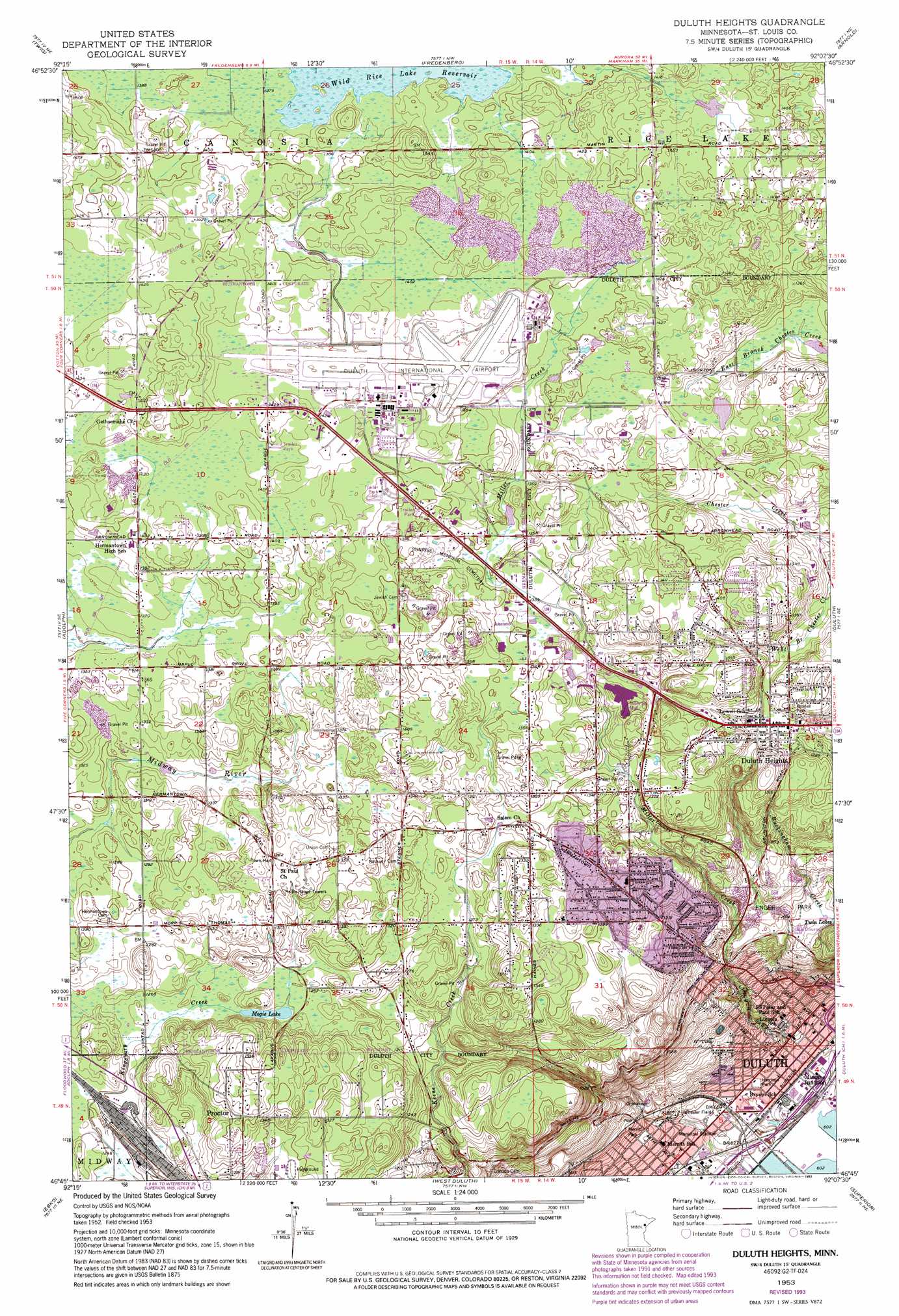
USGS Topo Quad 46092g2 - 1:24,000 scale
| Topo Map Name: | Duluth Heights |
| USGS Topo Quad ID: | 46092g2 |
| Print Size: | ca. 21 1/4" wide x 27" high |
| Southeast Coordinates: | 46.75° N latitude / 92.125° W longitude |
| Map Center Coordinates: | 46.8125° N latitude / 92.1875° W longitude |
| U.S. State: | MN |
| Filename: | o46092g2.jpg |
| Download Map JPG Image: | Duluth Heights topo map 1:24,000 scale |
| Map Type: | Topographic |
| Topo Series: | 7.5´ |
| Map Scale: | 1:24,000 |
| Source of Map Images: | United States Geological Survey (USGS) |
| Alternate Map Versions: |
Duluth Heights MN 1953, updated 1955 Download PDF Buy paper map Duluth Heights MN 1953, updated 1970 Download PDF Buy paper map Duluth Heights MN 1953, updated 1976 Download PDF Buy paper map Duluth Heights MN 1953, updated 1990 Download PDF Buy paper map Duluth Heights MN 1953, updated 1993 Download PDF Buy paper map Duluth Heights MN 2010 Download PDF Buy paper map Duluth Heights MN 2013 Download PDF Buy paper map Duluth Heights MN 2016 Download PDF Buy paper map |
1:24,000 Topo Quads surrounding Duluth Heights
Canyon |
Shaw |
Boulder Lake Reservoir |
Thompson Lake |
Barrs Lake |
Independence |
Twig |
Fredenberg |
Arnold |
French River |
Saginaw |
Adolph |
Duluth Heights |
Duluth |
Lakewood |
Cloquet |
Esko |
West Duluth |
Superior |
Parkland |
Wrenshall |
Frogner |
Borea |
Sunnyside |
South Range |
> Back to 46092e1 at 1:100,000 scale
> Back to 46092a1 at 1:250,000 scale
> Back to U.S. Topo Maps home
Duluth Heights topo map: Gazetteer
Duluth Heights: Airports
Duluth International Airport elevation 433m 1420′Music Man Heliport elevation 419m 1374′
Duluth Heights: Dams
Duluth-Superior Harbor Erie Pier Dike elevation 184m 603′Duluth Heights: Lakes
Mogie Lake elevation 383m 1256′Duluth Heights: Parks
Brewer Park elevation 384m 1259′Enger Park elevation 334m 1095′
Harrison Park elevation 196m 643′
Lincoln Park elevation 229m 751′
Merritt Park elevation 211m 692′
Pennell Park elevation 394m 1292′
Wheeler Field elevation 196m 643′
Duluth Heights: Populated Places
Bel Air Mobile Manor elevation 433m 1420′Birchwood Mobile Estates elevation 429m 1407′
Duluth Heights elevation 386m 1266′
Hermantown elevation 415m 1361′
Missabe Junction elevation 191m 626′
Saint Paul Church elevation 417m 1368′
Duluth Heights: Post Offices
Duluth Post Office elevation 194m 636′Duluth Heights: Streams
Miller Creek elevation 195m 639′Duluth Heights digital topo map on disk
Buy this Duluth Heights topo map showing relief, roads, GPS coordinates and other geographical features, as a high-resolution digital map file on DVD: