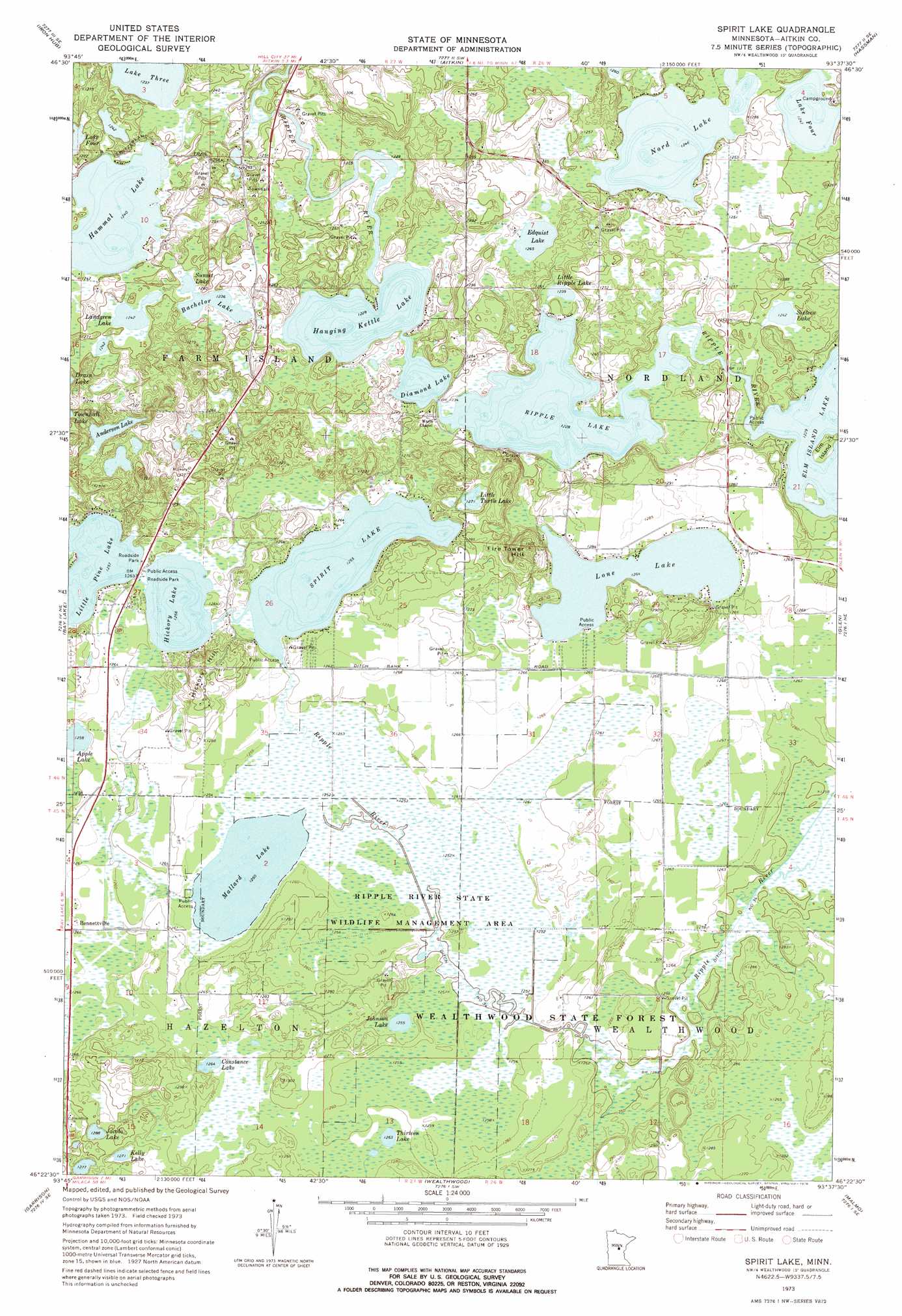
Spirit Lake Topo Map Minnesota
To zoom in, hover over the map of Spirit Lake
USGS Topo Quad 46093d6 - 1:24,000 scale
| Topo Map Name: | Spirit Lake |
| USGS Topo Quad ID: | 46093d6 |
| Print Size: | ca. 21 1/4" wide x 27" high |
| Southeast Coordinates: | 46.375° N latitude / 93.625° W longitude |
| Map Center Coordinates: | 46.4375° N latitude / 93.6875° W longitude |
| U.S. State: | MN |
| Filename: | o46093d6.jpg |
| Download Map JPG Image: | Spirit Lake topo map 1:24,000 scale |
| Map Type: | Topographic |
| Topo Series: | 7.5´ |
| Map Scale: | 1:24,000 |
| Source of Map Images: | United States Geological Survey (USGS) |
| Alternate Map Versions: |
Spirit Lake MN 1973, updated 1976 Download PDF Buy paper map Spirit Lake MN 2010 Download PDF Buy paper map Spirit Lake MN 2013 Download PDF Buy paper map Spirit Lake MN 2016 Download PDF Buy paper map |
1:24,000 Topo Quads surrounding Spirit Lake
Emily |
Ross Lake |
Esquagamah Lake |
Waukenabo |
Palisade |
Cuyuna |
Iron Hub |
Aitkin |
Hassman |
Kimberly |
Crosby |
Bay Lake |
Spirit Lake |
Glen |
Thor |
Grave Lake |
Garrison |
Wealthwood |
Malmo |
Thor Sw |
Platte Lake |
Vineland |
Onamia Nw |
Wahkon North |
Isle |
> Back to 46093a1 at 1:100,000 scale
> Back to 46092a1 at 1:250,000 scale
> Back to U.S. Topo Maps home
Spirit Lake topo map: Gazetteer
Spirit Lake: Canals
Ditch Number Thirtyfour elevation 381m 1250′Spirit Lake: Dams
Hanging Kettle Lake Dam elevation 378m 1240′Pine Lake Dam elevation 384m 1259′
Ripple Lake Dam elevation 374m 1227′
Spirit Lake: Islands
Elm Island elevation 378m 1240′Spirit Lake: Lakes
Anderson Lake elevation 387m 1269′Apple Lake elevation 383m 1256′
Bachelor Lake elevation 377m 1236′
Constance Lake elevation 385m 1263′
Diamond Lake elevation 374m 1227′
Edquist Lake elevation 387m 1269′
Elm Island Lake elevation 375m 1230′
Hammal Lake elevation 378m 1240′
Hanging Kettle Lake elevation 374m 1227′
Hickory Lake elevation 383m 1256′
Jacobs Lake elevation 393m 1289′
Johnson Lake elevation 383m 1256′
Kelly Lake elevation 388m 1272′
Lake Four elevation 380m 1246′
Lake Three elevation 377m 1236′
Landgren Lake elevation 379m 1243′
Little Pine Lake elevation 383m 1256′
Little Ripple Lake elevation 378m 1240′
Little Turtle Lake elevation 388m 1272′
Lone Lake elevation 385m 1263′
Mallard Lake elevation 381m 1250′
Nord Lake elevation 380m 1246′
Ripple Lake elevation 374m 1227′
Sixteen Lake elevation 379m 1243′
Spirit Lake elevation 383m 1256′
Sunset Lake elevation 377m 1236′
Thirteen Lake elevation 385m 1263′
Spirit Lake: Parks
Ripple River State Wildlife Management Area elevation 381m 1250′Spirit Lake: Populated Places
Bennettville elevation 386m 1266′Spirit Lake: Reservoirs
Hanging Kettle Lake elevation 378m 1240′Pine Lake elevation 384m 1259′
Ripple Lake elevation 374m 1227′
Spirit Lake: Summits
Fire Tower Hill elevation 424m 1391′Hickory Hill elevation 401m 1315′
Spirit Lake digital topo map on disk
Buy this Spirit Lake topo map showing relief, roads, GPS coordinates and other geographical features, as a high-resolution digital map file on DVD: