Crosby Topo Map Minnesota
To zoom in, hover over the map of Crosby
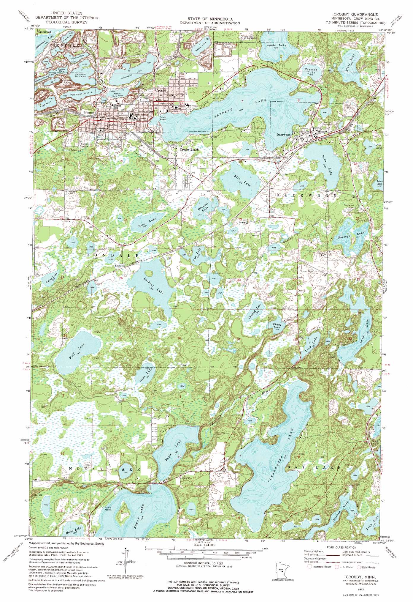
USGS Topo Quad 46093d8 - 1:24,000 scale
| Topo Map Name: | Crosby |
| USGS Topo Quad ID: | 46093d8 |
| Print Size: | ca. 21 1/4" wide x 27" high |
| Southeast Coordinates: | 46.375° N latitude / 93.875° W longitude |
| Map Center Coordinates: | 46.4375° N latitude / 93.9375° W longitude |
| U.S. State: | MN |
| Filename: | o46093d8.jpg |
| Download Map JPG Image: | Crosby topo map 1:24,000 scale |
| Map Type: | Topographic |
| Topo Series: | 7.5´ |
| Map Scale: | 1:24,000 |
| Source of Map Images: | United States Geological Survey (USGS) |
| Alternate Map Versions: |
Crosby MN 1973, updated 1976 Download PDF Buy paper map Crosby MN 2010 Download PDF Buy paper map Crosby MN 2013 Download PDF Buy paper map Crosby MN 2016 Download PDF Buy paper map |
1:24,000 Topo Quads surrounding Crosby
Lower Whitefish Lake |
Cross Lake |
Emily |
Ross Lake |
Esquagamah Lake |
Pelican Lake |
Trommald |
Cuyuna |
Iron Hub |
Aitkin |
Merrifield |
Riverton |
Crosby |
Bay Lake |
Spirit Lake |
Brainerd |
South Long Lake |
Grave Lake |
Garrison |
Wealthwood |
Lastrup Nw |
Shephard |
Platte Lake |
Vineland |
Onamia Nw |
> Back to 46093a1 at 1:100,000 scale
> Back to 46092a1 at 1:250,000 scale
> Back to U.S. Topo Maps home
Crosby topo map: Gazetteer
Crosby: Airports
Lindeys Landing Airport elevation 397m 1302′Mals-Serpent Lake Seaplane Base elevation 384m 1259′
Crosby: Capes
Indian Point elevation 385m 1263′Crosby: Dams
Clearwater Lake Dam elevation 381m 1250′Hawthorne Dam elevation 396m 1299′
Crosby: Lakes
Agate Lake elevation 380m 1246′Black Lake elevation 380m 1246′
Cascade Lake elevation 380m 1246′
Crato Lake elevation 384m 1259′
Eagle Lake elevation 374m 1227′
Jim Lake elevation 388m 1272′
Lake Ann elevation 382m 1253′
Lookout Lake elevation 385m 1263′
Loon Lake elevation 383m 1256′
Loon Lake elevation 385m 1263′
Menomin Lake elevation 364m 1194′
Nokay Lake elevation 374m 1227′
Olander Lake elevation 384m 1259′
Oreland Lake elevation 385m 1263′
Peterson Lake elevation 385m 1263′
Placid Lake elevation 385m 1263′
Reno Lake elevation 382m 1253′
Rice Lake elevation 382m 1253′
Rice Lake elevation 384m 1259′
Rose Lake elevation 385m 1263′
Serpent Lake elevation 380m 1246′
Vang Lake elevation 385m 1263′
Wolf Lake elevation 385m 1263′
Crosby: Mines
Croft Mine elevation 379m 1243′Feigh Mine elevation 360m 1181′
Hopkins Mine elevation 356m 1167′
Joan Mine elevation 361m 1184′
Louise Mine elevation 356m 1167′
Mahnomen Number One Mine elevation 356m 1167′
Mahnomen Number Three Mine elevation 356m 1167′
Manuel Mine elevation 375m 1230′
Pennington Mine elevation 362m 1187′
Portsmouth Mine elevation 364m 1194′
Crosby: Parks
Cayuna Range Historical Marker elevation 384m 1259′Croft Mine Historical Park elevation 383m 1256′
Franklin Park elevation 385m 1263′
Portsmouth Mine Geological Marker elevation 377m 1236′
Wayside Park elevation 384m 1259′
Crosby: Populated Places
Armour Number Two Mine elevation 370m 1213′Crosby elevation 384m 1259′
Crosby Beach elevation 386m 1266′
Deerwood elevation 389m 1276′
Deerwood Mobile Home Park elevation 389m 1276′
Ironton elevation 384m 1259′
Klondyke elevation 387m 1269′
Oreland elevation 387m 1269′
Serpent Lake Mobile Home Park elevation 385m 1263′
Towns Edge Mobile Home Park elevation 384m 1259′
Crosby: Post Offices
Crosby Post Office elevation 384m 1259′Deerwood Post Office elevation 391m 1282′
Ironton Post Office elevation 383m 1256′
Klondike Post Office (historical) elevation 387m 1269′
Oreland Post Office (historical) elevation 387m 1269′
Crosby: Reservoirs
Clearwater Lake elevation 381m 1250′Portage Lake elevation 377m 1236′
Crosby: Streams
Serpent Creek elevation 367m 1204′Crosby digital topo map on disk
Buy this Crosby topo map showing relief, roads, GPS coordinates and other geographical features, as a high-resolution digital map file on DVD: