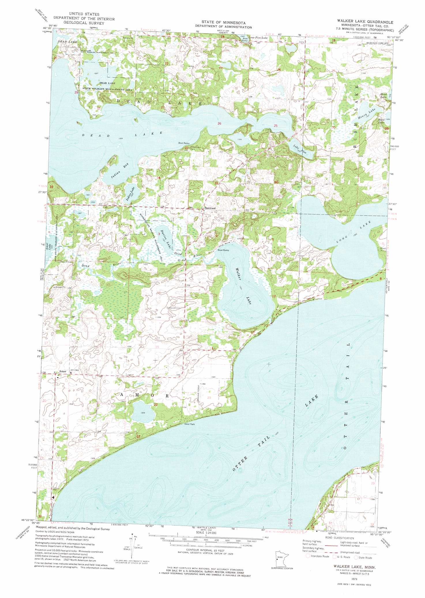
Walker Lake Topo Map Minnesota
To zoom in, hover over the map of Walker Lake
USGS Topo Quad 46095d6 - 1:24,000 scale
| Topo Map Name: | Walker Lake |
| USGS Topo Quad ID: | 46095d6 |
| Print Size: | ca. 21 1/4" wide x 27" high |
| Southeast Coordinates: | 46.375° N latitude / 95.625° W longitude |
| Map Center Coordinates: | 46.4375° N latitude / 95.6875° W longitude |
| U.S. State: | MN |
| Filename: | o46095d6.jpg |
| Download Map JPG Image: | Walker Lake topo map 1:24,000 scale |
| Map Type: | Topographic |
| Topo Series: | 7.5´ |
| Map Scale: | 1:24,000 |
| Source of Map Images: | United States Geological Survey (USGS) |
| Alternate Map Versions: |
Walker Lake MN 1973, updated 1975 Download PDF Buy paper map Walker Lake MN 2010 Download PDF Buy paper map Walker Lake MN 2013 Download PDF Buy paper map Walker Lake MN 2016 Download PDF Buy paper map |
1:24,000 Topo Quads surrounding Walker Lake
Lake Franklin |
Vergas |
Frazee |
Little Pine Lake |
New York Mills Nw |
Lake Lida |
Star Lake |
Dent |
Perham |
New York Mills West |
Heilberger Lake |
Phelps |
Walker Lake |
Ottertail |
Heinola |
Wall Lake |
Underwood |
Battle Lake |
Vining |
Henning |
Dalton |
Stalker Lake |
Eagle Lake |
Inspiration Peak |
Parkers Prairie Nw |
> Back to 46095a1 at 1:100,000 scale
> Back to 46094a1 at 1:250,000 scale
> Back to U.S. Topo Maps home
Walker Lake topo map: Gazetteer
Walker Lake: Bays
Indian Bay elevation 403m 1322′Walker Lake: Dams
Dead Lake East Dam elevation 403m 1322′Walker Lake: Lakes
Davies Lake elevation 403m 1322′Henry Lake elevation 403m 1322′
Indian Lake elevation 403m 1322′
Lake Alice elevation 403m 1322′
Long Lake elevation 403m 1322′
Otter Tail Lake elevation 403m 1322′
Walker Lake elevation 403m 1322′
Walker Lake: Parks
Amor Park elevation 406m 1332′Craigie Flour Mill Historical Marker elevation 408m 1338′
Davies State Wildlife Management Area elevation 405m 1328′
Dead Lake Park elevation 411m 1348′
Dead Lake State Wildlife Management Area elevation 403m 1322′
Walker Lake: Populated Places
Amor elevation 415m 1361′Basswood elevation 415m 1361′
Walker Lake: Post Offices
Amor Post Office (historical) elevation 415m 1361′Basswood Post Office (historical) elevation 415m 1361′
Vida Post Office (historical) elevation 415m 1361′
Walker Lake: Reservoirs
Dead Lake elevation 403m 1322′Walker Lake: Streams
Dead River elevation 403m 1322′Walker Lake digital topo map on disk
Buy this Walker Lake topo map showing relief, roads, GPS coordinates and other geographical features, as a high-resolution digital map file on DVD: