Vergas Topo Map Minnesota
To zoom in, hover over the map of Vergas
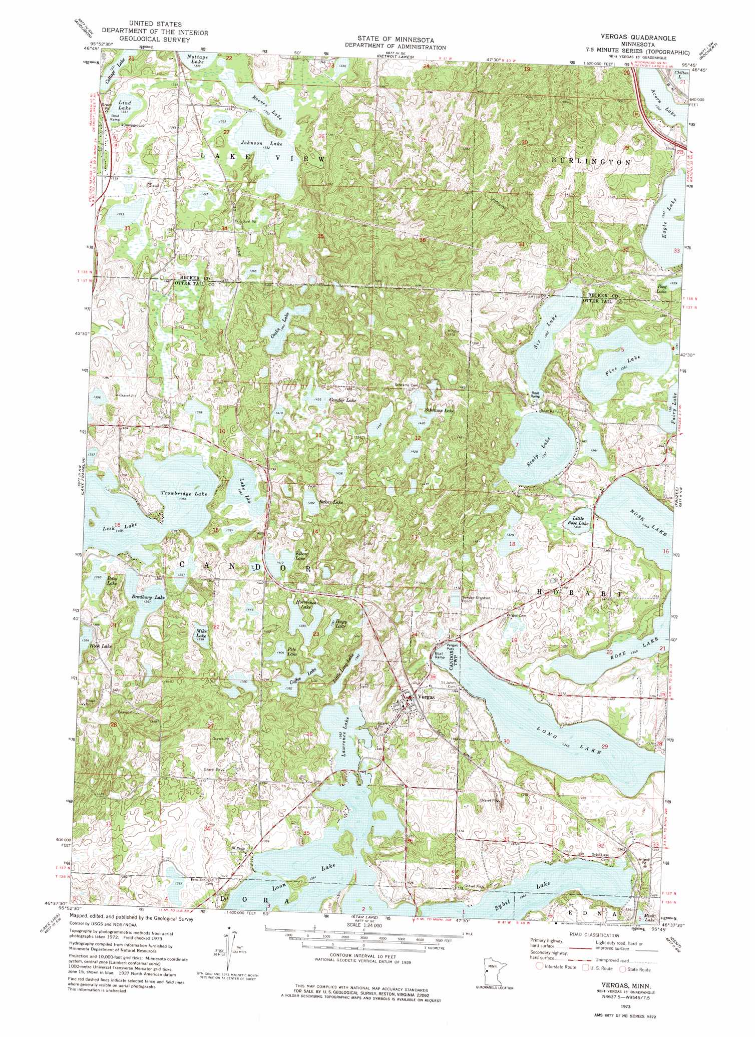
USGS Topo Quad 46095f7 - 1:24,000 scale
| Topo Map Name: | Vergas |
| USGS Topo Quad ID: | 46095f7 |
| Print Size: | ca. 21 1/4" wide x 27" high |
| Southeast Coordinates: | 46.625° N latitude / 95.75° W longitude |
| Map Center Coordinates: | 46.6875° N latitude / 95.8125° W longitude |
| U.S. State: | MN |
| Filename: | o46095f7.jpg |
| Download Map JPG Image: | Vergas topo map 1:24,000 scale |
| Map Type: | Topographic |
| Topo Series: | 7.5´ |
| Map Scale: | 1:24,000 |
| Source of Map Images: | United States Geological Survey (USGS) |
| Alternate Map Versions: |
Vergas MN 1973, updated 1975 Download PDF Buy paper map Vergas MN 2010 Download PDF Buy paper map Vergas MN 2013 Download PDF Buy paper map Vergas MN 2016 Download PDF Buy paper map |
1:24,000 Topo Quads surrounding Vergas
Lake Park |
Mount Rainier East |
Richwood |
Flat Lake |
Height Of Land Lake |
Big Cormorant Lake |
Audubon |
Detroit Lakes |
Rochert |
Toad Mountain |
Cormorant |
Lake Franklin |
Vergas |
Frazee |
Little Pine Lake |
Pelican Rapids |
Lake Lida |
Star Lake |
Dent |
Perham |
Erhard |
Heilberger Lake |
Phelps |
Walker Lake |
Ottertail |
> Back to 46095e1 at 1:100,000 scale
> Back to 46094a1 at 1:250,000 scale
> Back to U.S. Topo Maps home
Vergas topo map: Gazetteer
Vergas: Lakes
Acorn Lake elevation 415m 1361′Baker Lake elevation 425m 1394′
Bass Lake elevation 415m 1361′
Bradbury Lake elevation 415m 1361′
Candor Lake elevation 438m 1437′
Coffee Lake elevation 422m 1384′
Cottage Lake elevation 406m 1332′
Eagle Lake elevation 417m 1368′
Elbow Lake elevation 431m 1414′
Five Lake elevation 415m 1361′
Happ Lake elevation 426m 1397′
Horseshoe Lake elevation 426m 1397′
Johnson Lake elevation 406m 1332′
Lake Ida elevation 415m 1361′
Lawrence Lake elevation 415m 1361′
Leek Lake elevation 414m 1358′
Lind Lake elevation 406m 1332′
Little Long Lake elevation 419m 1374′
Little Rose Lake elevation 411m 1348′
Long Lake elevation 410m 1345′
Loon Lake elevation 415m 1361′
Mike Lake elevation 426m 1397′
Nottage Lake elevation 406m 1332′
Pete Lake elevation 428m 1404′
Reeves Lake elevation 407m 1335′
Scalp Lake elevation 414m 1358′
Schrams Lake elevation 437m 1433′
Six Lake elevation 416m 1364′
Sybil Lake elevation 415m 1361′
Trowbridge Lake elevation 414m 1358′
Vergas: Parks
Vergas Park elevation 414m 1358′Vergas: Populated Places
Heisler Manufactured Home Park elevation 418m 1371′Vergas elevation 431m 1414′
Vergas: Post Offices
Bradbury Post Office elevation 428m 1404′Gresham Post Office (historical) elevation 437m 1433′
Lake Sybil Post Office (historical) elevation 421m 1381′
Vergas Post Office (historical) elevation 431m 1414′
Vergas digital topo map on disk
Buy this Vergas topo map showing relief, roads, GPS coordinates and other geographical features, as a high-resolution digital map file on DVD: