Abercrombie Topo Map Minnesota
To zoom in, hover over the map of Abercrombie
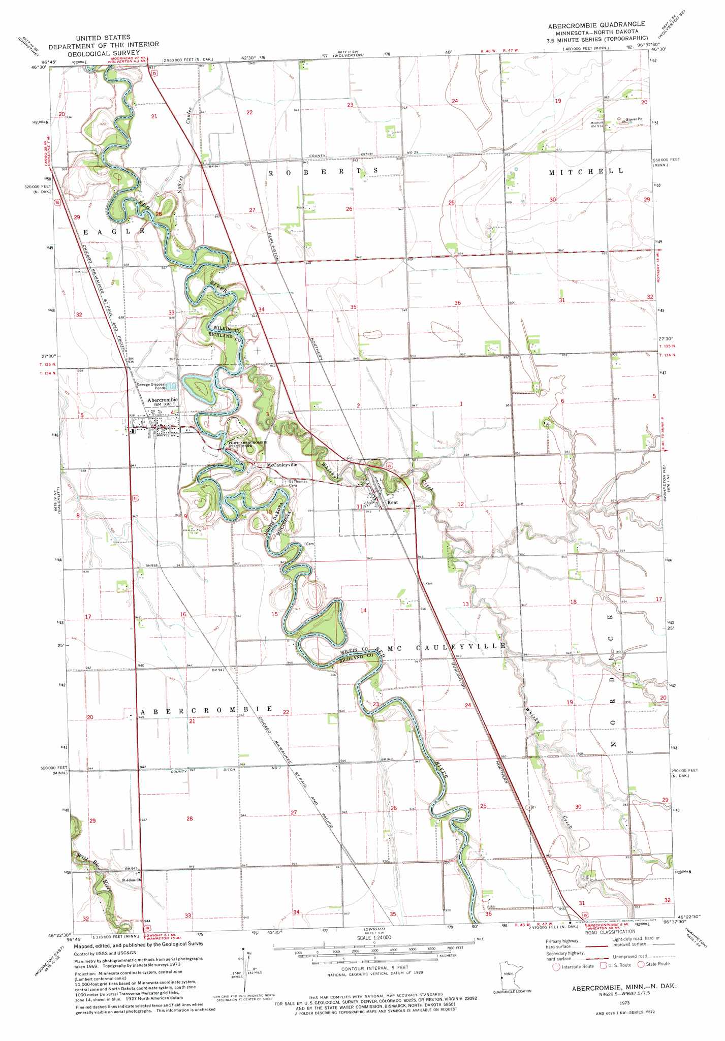
USGS Topo Quad 46096d6 - 1:24,000 scale
| Topo Map Name: | Abercrombie |
| USGS Topo Quad ID: | 46096d6 |
| Print Size: | ca. 21 1/4" wide x 27" high |
| Southeast Coordinates: | 46.375° N latitude / 96.625° W longitude |
| Map Center Coordinates: | 46.4375° N latitude / 96.6875° W longitude |
| U.S. States: | MN, ND |
| Filename: | o46096d6.jpg |
| Download Map JPG Image: | Abercrombie topo map 1:24,000 scale |
| Map Type: | Topographic |
| Topo Series: | 7.5´ |
| Map Scale: | 1:24,000 |
| Source of Map Images: | United States Geological Survey (USGS) |
| Alternate Map Versions: |
Abercrombie ND 1973, updated 1975 Download PDF Buy paper map Abercrombie ND 2011 Download PDF Buy paper map Abercrombie ND 2014 Download PDF Buy paper map |
1:24,000 Topo Quads surrounding Abercrombie
Norman |
Hickson |
Comstock |
Baker |
Barnesville |
Walcott |
Christine |
Wolverton |
Wolverton Se |
Barnesville Sw |
Mooreton Nw |
Galchutt |
Abercrombie |
Wahpeton Ne |
Rothsay Nw |
Mooreton West |
Mooreton East |
Dwight |
Wahpeton |
Everdell |
Mantador |
Great Bend |
Fairmount Nw |
South Of Wahpeton |
Doran |
> Back to 46096a1 at 1:100,000 scale
> Back to 46096a1 at 1:250,000 scale
> Back to U.S. Topo Maps home
Abercrombie topo map: Gazetteer
Abercrombie: Canals
County Ditch Number 1 elevation 287m 941′County Ditch Number Twentynine elevation 288m 944′
Abercrombie: Parks
Fort Abercrombie Historical Marker elevation 288m 944′Fort Abercrombie State Park elevation 286m 938′
Abercrombie: Populated Places
Abercrombie elevation 286m 938′Kent elevation 287m 941′
McCauleyville elevation 285m 935′
Abercrombie: Post Offices
Kent Post Office elevation 287m 941′McCauleysville Post Office (historical) elevation 285m 935′
Abercrombie: Streams
Whisky Creek elevation 279m 915′Abercrombie digital topo map on disk
Buy this Abercrombie topo map showing relief, roads, GPS coordinates and other geographical features, as a high-resolution digital map file on DVD:
Eastern North Dakota & Eastern South Dakota
Buy digital topo maps: Eastern North Dakota & Eastern South Dakota