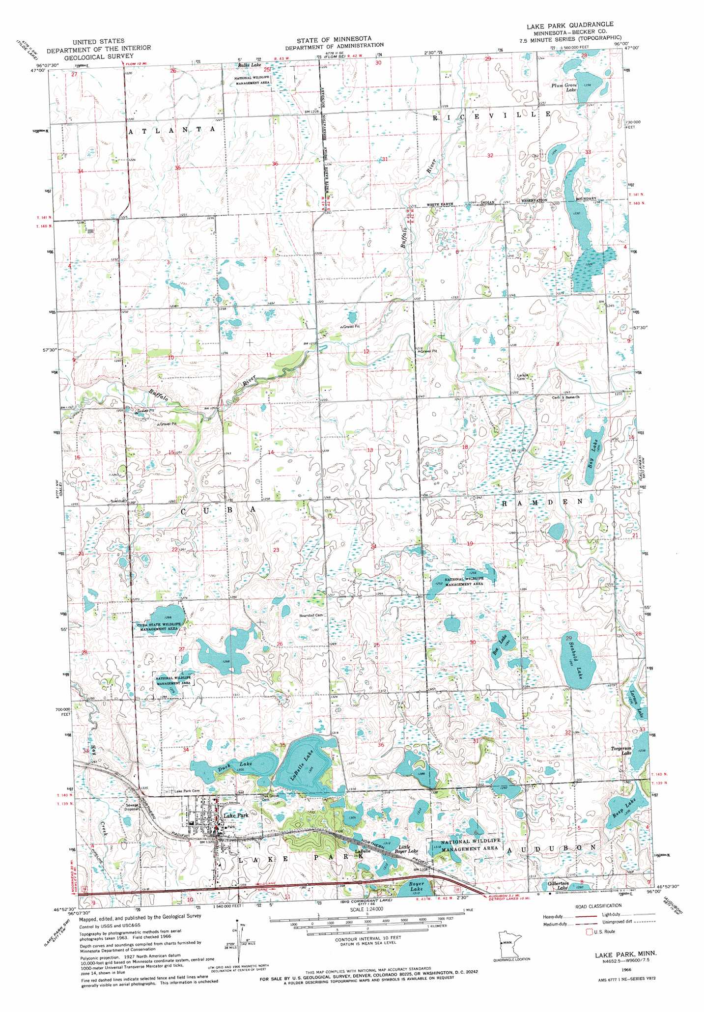
Lake Park Topo Map Minnesota
To zoom in, hover over the map of Lake Park
USGS Topo Quad 46096h1 - 1:24,000 scale
| Topo Map Name: | Lake Park |
| USGS Topo Quad ID: | 46096h1 |
| Print Size: | ca. 21 1/4" wide x 27" high |
| Southeast Coordinates: | 46.875° N latitude / 96° W longitude |
| Map Center Coordinates: | 46.9375° N latitude / 96.0625° W longitude |
| U.S. State: | MN |
| Filename: | o46096h1.jpg |
| Download Map JPG Image: | Lake Park topo map 1:24,000 scale |
| Map Type: | Topographic |
| Topo Series: | 7.5´ |
| Map Scale: | 1:24,000 |
| Source of Map Images: | United States Geological Survey (USGS) |
| Alternate Map Versions: |
Lake Park MN 1966, updated 1967 Download PDF Buy paper map Lake Park MN 2010 Download PDF Buy paper map Lake Park MN 2013 Download PDF Buy paper map Lake Park MN 2016 Download PDF Buy paper map |
1:24,000 Topo Quads surrounding Lake Park
Syre |
Flom |
Flom Ne |
Waubun |
Ogema Ne |
Ulen |
Tilde Lake |
Flom Se |
Ogema |
White Earth |
Hawley |
Dale |
Lake Park |
Mount Rainier East |
Richwood |
Hawley Se |
Lake Park Sw |
Big Cormorant Lake |
Audubon |
Detroit Lakes |
Big Slough |
Rollag |
Cormorant |
Lake Franklin |
Vergas |
> Back to 46096e1 at 1:100,000 scale
> Back to 46096a1 at 1:250,000 scale
> Back to U.S. Topo Maps home
Lake Park topo map: Gazetteer
Lake Park: Dams
August Nelson Junior Dam elevation 401m 1315′Hamden Gun Club Dam elevation 375m 1230′
Lake Park: Lakes
Bay Lake elevation 374m 1227′Boe Lake elevation 386m 1266′
Duck Lake elevation 398m 1305′
LaBelle Lake elevation 398m 1305′
Larson Lake elevation 377m 1236′
Little Boyer Lake elevation 402m 1318′
Plum Grove Lake elevation 377m 1236′
Reep Lake elevation 377m 1236′
Seabold Lake elevation 385m 1263′
Torgerson Lake elevation 377m 1236′
Lake Park: Parks
Cuba State Wildlife Management Area elevation 387m 1269′Lake Park: Populated Places
LaBelle elevation 405m 1328′Lake Park elevation 410m 1345′
Lake Park Trailer Court elevation 410m 1345′
Town and Country Estates Mobile Home Park elevation 414m 1358′
Lake Park: Post Offices
Lake Park Post Office (historical) elevation 410m 1345′Lake Park: Reservoirs
Rassom Lake elevation 375m 1230′Lake Park digital topo map on disk
Buy this Lake Park topo map showing relief, roads, GPS coordinates and other geographical features, as a high-resolution digital map file on DVD:
Eastern North Dakota & Eastern South Dakota
Buy digital topo maps: Eastern North Dakota & Eastern South Dakota