Valley City West Topo Map North Dakota
To zoom in, hover over the map of Valley City West
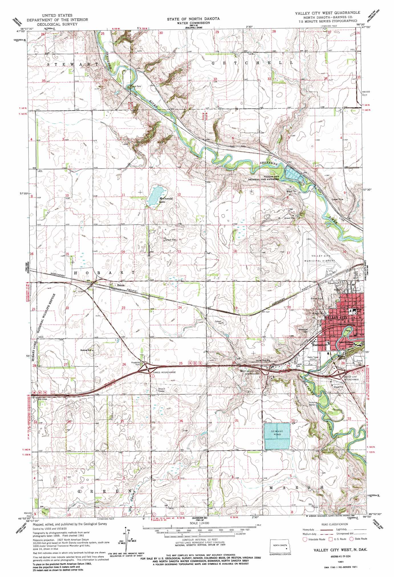
USGS Topo Quad 46098h1 - 1:24,000 scale
| Topo Map Name: | Valley City West |
| USGS Topo Quad ID: | 46098h1 |
| Print Size: | ca. 21 1/4" wide x 27" high |
| Southeast Coordinates: | 46.875° N latitude / 98° W longitude |
| Map Center Coordinates: | 46.9375° N latitude / 98.0625° W longitude |
| U.S. State: | ND |
| Filename: | O46098H1.jpg |
| Download Map JPG Image: | Valley City West topo map 1:24,000 scale |
| Map Type: | Topographic |
| Topo Series: | 7.5´ |
| Map Scale: | 1:24,000 |
| Source of Map Images: | United States Geological Survey (USGS) |
| Alternate Map Versions: |
Valley City West ND 1961, updated 1963 Download PDF Buy paper map Valley City West ND 1961, updated 1986 Download PDF Buy paper map Valley City West ND 2011 Download PDF Buy paper map Valley City West ND 2014 Download PDF Buy paper map |
1:24,000 Topo Quads surrounding Valley City West
Wimbledon Ne |
Dazey |
Dazey Ne |
Sibley |
Pillsbury |
Leal |
Rogers |
Baldhill Dam |
Pillsbury Sw |
Pillsbury Se |
Eckelson |
Sanborn |
Valley City West |
Valley City East |
Oriska |
Eckelson Se |
Moon Lake |
Sanborn Se |
Fingal Sw |
Fingal |
Marion Ne |
Litchville |
Hastings |
Kathryn |
Nome |
> Back to 46098e1 at 1:100,000 scale
> Back to 46098a1 at 1:250,000 scale
> Back to U.S. Topo Maps home
Valley City West topo map: Gazetteer
Valley City West: Airports
Barnes County Municipal Airport elevation 423m 1387′Valley City West: Crossings
Oakes Interchange elevation 442m 1450′Valley City Interchange elevation 389m 1276′
West Valley City Interchange elevation 387m 1269′
Valley City West: Dams
Valley City Mill Dam elevation 377m 1236′Valley City Park Dam elevation 409m 1341′
Valley City West: Lakes
McDonald Lake elevation 426m 1397′Valley City West: Parks
Faust Park elevation 376m 1233′Pioneer Park elevation 381m 1250′
Valley City West: Populated Places
Berea elevation 436m 1430′Valley City elevation 373m 1223′
Valley City West: Swamps
Big Swamp elevation 426m 1397′Valley City West digital topo map on disk
Buy this Valley City West topo map showing relief, roads, GPS coordinates and other geographical features, as a high-resolution digital map file on DVD:
Eastern North Dakota & Eastern South Dakota
Buy digital topo maps: Eastern North Dakota & Eastern South Dakota