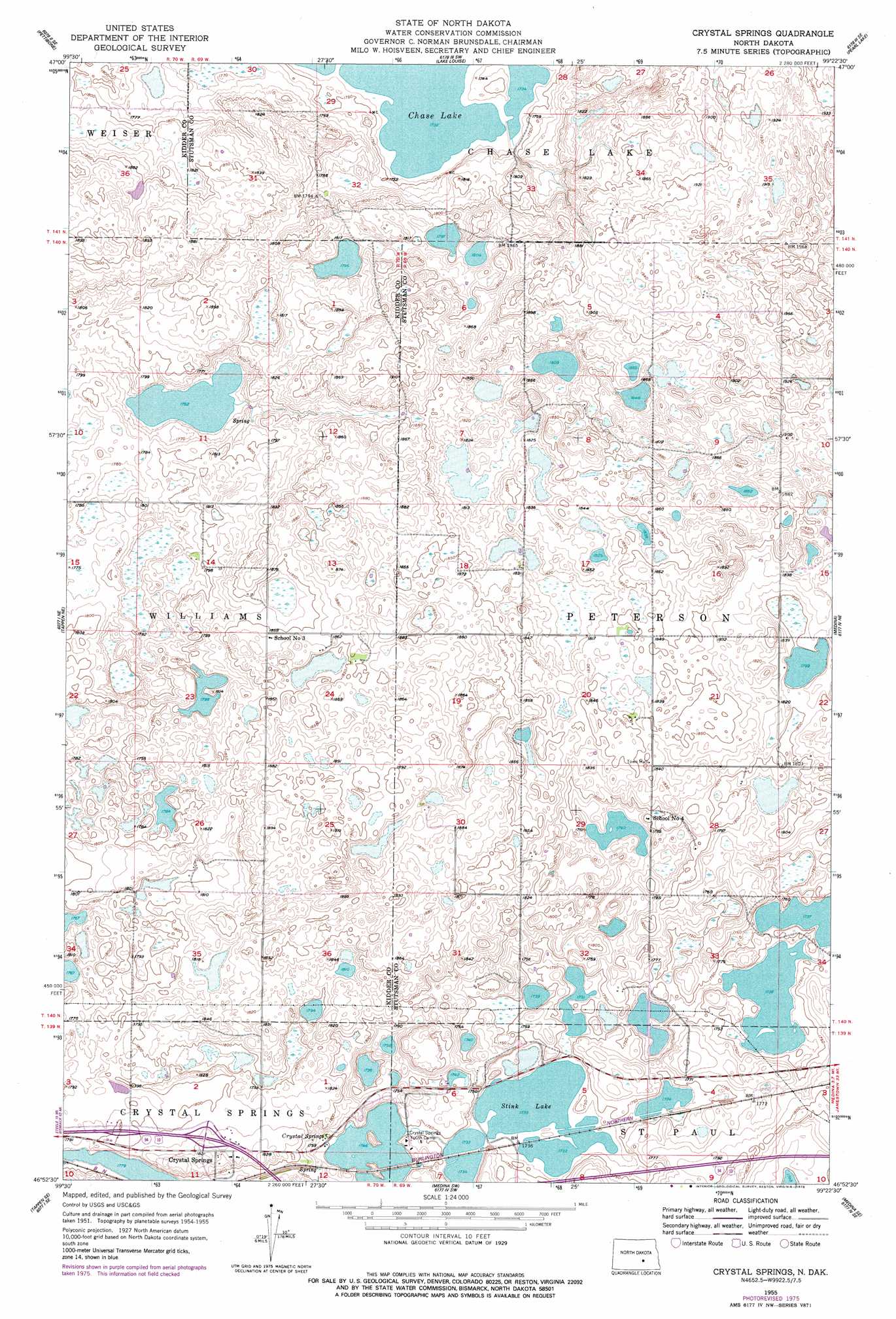
Crystal Springs Topo Map North Dakota
To zoom in, hover over the map of Crystal Springs
USGS Topo Quad 46099h4 - 1:24,000 scale
| Topo Map Name: | Crystal Springs |
| USGS Topo Quad ID: | 46099h4 |
| Print Size: | ca. 21 1/4" wide x 27" high |
| Southeast Coordinates: | 46.875° N latitude / 99.375° W longitude |
| Map Center Coordinates: | 46.9375° N latitude / 99.4375° W longitude |
| U.S. State: | ND |
| Filename: | O46099H4.jpg |
| Download Map JPG Image: | Crystal Springs topo map 1:24,000 scale |
| Map Type: | Topographic |
| Topo Series: | 7.5´ |
| Map Scale: | 1:24,000 |
| Source of Map Images: | United States Geological Survey (USGS) |
| Alternate Map Versions: |
Crystal Springs ND 1955, updated 1956 Download PDF Buy paper map Crystal Springs ND 1955, updated 1978 Download PDF Buy paper map Crystal Springs ND 2011 Download PDF Buy paper map Crystal Springs ND 2014 Download PDF Buy paper map |
1:24,000 Topo Quads surrounding Crystal Springs
Des Moines Lake |
Lake Williams |
Woodworth Nw |
Woodworth |
Goldwin |
Kunkel Lake |
Pettibone |
Lake Louise |
Pearl Lake |
Goldwin Sw |
Tappen North |
Tappen Ne |
Crystal Springs |
Medina |
Cleveland Nw |
Tappen South |
Tappen Se |
Medina Sw |
Medina Se |
Cleveland Sw |
Alkaline Lake Nw |
Alkaline Lake |
Streeter Nw |
Streeter |
Gackle North |
> Back to 46099e1 at 1:100,000 scale
> Back to 46098a1 at 1:250,000 scale
> Back to U.S. Topo Maps home
Crystal Springs topo map: Gazetteer
Crystal Springs: Dams
Chase Lake Dam elevation 529m 1735′Crystal Springs: Lakes
Stink Lake elevation 529m 1735′Crystal Springs: Populated Places
Crystal Springs elevation 559m 1833′Crystal Springs: Reservoirs
Chase Lake elevation 529m 1735′Crystal Springs: Springs
Crystal Springs elevation 534m 1751′Crystal Springs digital topo map on disk
Buy this Crystal Springs topo map showing relief, roads, GPS coordinates and other geographical features, as a high-resolution digital map file on DVD:
Eastern North Dakota & Eastern South Dakota
Buy digital topo maps: Eastern North Dakota & Eastern South Dakota