Bismarck Topo Map North Dakota
To zoom in, hover over the map of Bismarck
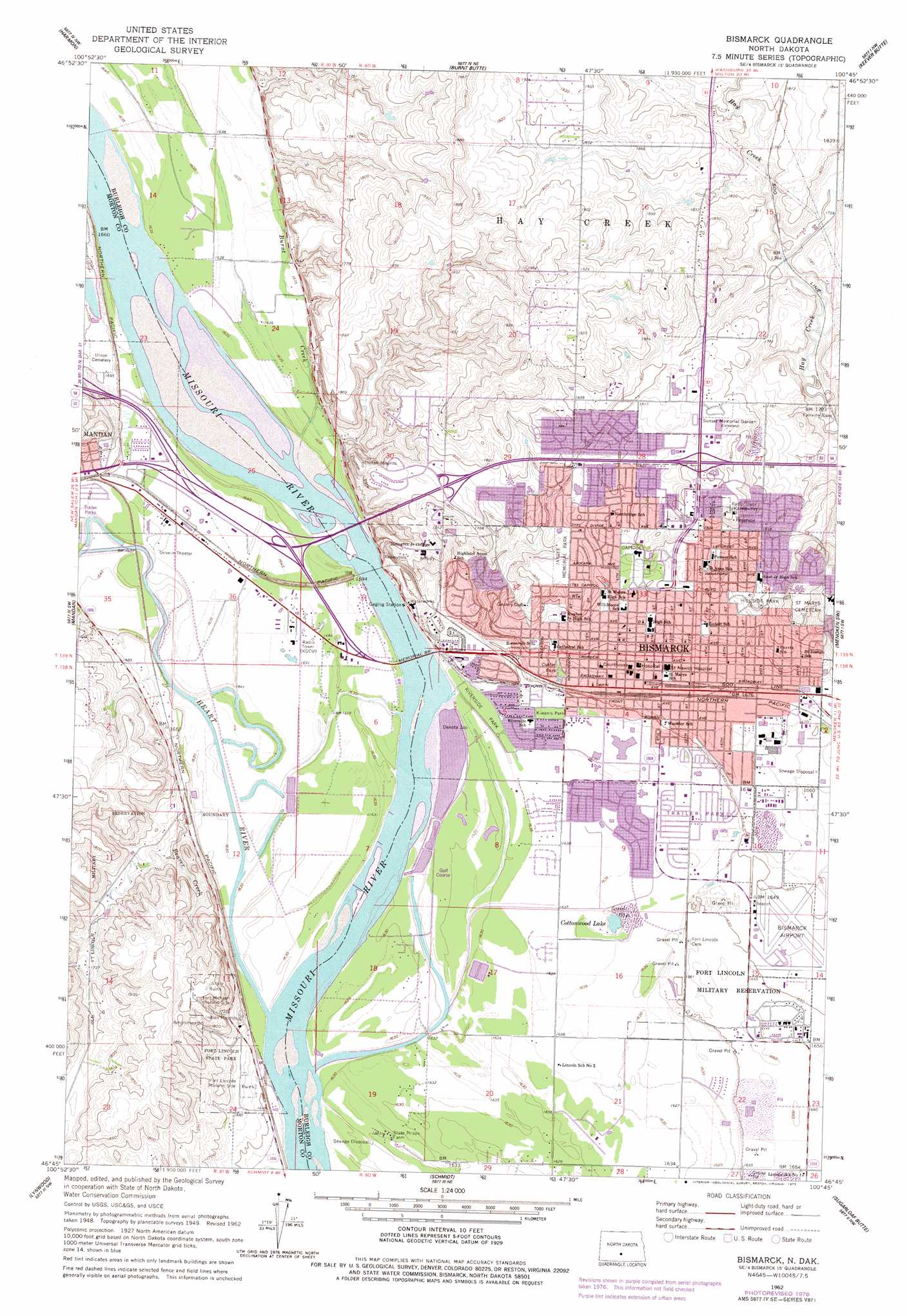
USGS Topo Quad 46100g7 - 1:24,000 scale
| Topo Map Name: | Bismarck |
| USGS Topo Quad ID: | 46100g7 |
| Print Size: | ca. 21 1/4" wide x 27" high |
| Southeast Coordinates: | 46.75° N latitude / 100.75° W longitude |
| Map Center Coordinates: | 46.8125° N latitude / 100.8125° W longitude |
| U.S. State: | ND |
| Filename: | O46100G7.jpg |
| Download Map JPG Image: | Bismarck topo map 1:24,000 scale |
| Map Type: | Topographic |
| Topo Series: | 7.5´ |
| Map Scale: | 1:24,000 |
| Source of Map Images: | United States Geological Survey (USGS) |
| Alternate Map Versions: |
Bismarck ND 1950, updated 1950 Download PDF Buy paper map Bismarck ND 1962, updated 1964 Download PDF Buy paper map Bismarck ND 1962, updated 1977 Download PDF Buy paper map Bismarck ND 1962, updated 1977 Download PDF Buy paper map Bismarck ND 2011 Download PDF Buy paper map Bismarck ND 2014 Download PDF Buy paper map |
1:24,000 Topo Quads surrounding Bismarck
Fort Clark Se |
Price |
Wilton Se |
Baldwin |
Regan Se |
Crown Butte |
Harmon |
Burnt Butte |
Keever Butte |
Solberg Butte |
Crown Butte Lake |
Mandan |
Bismarck |
Menoken Sw |
Menoken |
Fallon Ne |
Lynwood |
Schmidt |
Sugarloaf Butte |
Huff Ne |
Fallon |
Saint Anthony |
The Hogback |
Huff |
Fort Rice |
> Back to 46100e1 at 1:100,000 scale
> Back to 46100a1 at 1:250,000 scale
> Back to U.S. Topo Maps home
Bismarck topo map: Gazetteer
Bismarck: Airports
Bismarck Municipal Airport elevation 503m 1650′Missouri Valley Spraying Private Airfield elevation 499m 1637′
Bismarck: Bridges
Memorial Bridge elevation 495m 1624′Bismarck: Lakes
Cottonwood Lake elevation 496m 1627′Bismarck: Parks
Bismarck Community Bowl elevation 547m 1794′Custer Park elevation 507m 1663′
Dakota Zoo elevation 498m 1633′
Fork McKeen Historic Site elevation 581m 1906′
Fort Abraham Lincoln (historical) elevation 506m 1660′
Fort Abraham Lincoln State Park elevation 525m 1722′
Hillside Park elevation 539m 1768′
Kiwanis Park elevation 499m 1637′
Pioneer Park elevation 541m 1774′
Riverside Park elevation 500m 1640′
Bismarck: Populated Places
Bismarck elevation 514m 1686′Chance Mobile Home Park elevation 519m 1702′
Colonial Estates elevation 499m 1637′
Evas Mobile Home Court elevation 514m 1686′
Frontier Homesteads elevation 500m 1640′
Hay Creek Court elevation 547m 1794′
Hi-loh Mobile Park elevation 502m 1646′
Holiday Park elevation 499m 1637′
North Valley Park elevation 544m 1784′
On-a-Slant Village (historical) elevation 519m 1702′
Parkview Estates elevation 499m 1637′
Sky Way Mobile Home Park elevation 499m 1637′
Stardust Terrace elevation 500m 1640′
Tatley Meadows elevation 499m 1637′
Terrace Heights Mobile Home Park elevation 512m 1679′
Twin City Estates elevation 502m 1646′
Bismarck: Streams
Beaver Creek elevation 497m 1630′Burnt Creek elevation 496m 1627′
Heart River elevation 495m 1624′
Bismarck digital topo map on disk
Buy this Bismarck topo map showing relief, roads, GPS coordinates and other geographical features, as a high-resolution digital map file on DVD:
Eastern North Dakota & Eastern South Dakota
Buy digital topo maps: Eastern North Dakota & Eastern South Dakota