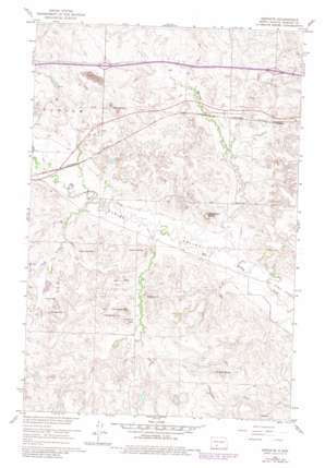
Dengate Topo Map North Dakota
To zoom in, hover over the map of Dengate
USGS Topo Quad 46101g6 - 1:24,000 scale
| Topo Map Name: | Dengate |
| USGS Topo Quad ID: | 46101g6 |
| Print Size: | ca. 21 1/4" wide x 27" high |
| Southeast Coordinates: | 46.75° N latitude / 101.625° W longitude |
| Map Center Coordinates: | 46.8125° N latitude / 101.6875° W longitude |
| U.S. State: | ND |
| Filename: | O46101G6.jpg |
| Download Map JPG Image: | Dengate topo map 1:24,000 scale |
| Map Type: | Topographic |
| Topo Series: | 7.5´ |
| Map Scale: | 1:24,000 |
| Source of Map Images: | United States Geological Survey (USGS) |
| Alternate Map Versions: |
Dengate ND 1960, updated 1961 Download PDF Buy paper map Dengate ND 1960, updated 1980 Download PDF Buy paper map Dengate ND 2011 Download PDF Buy paper map Dengate ND 2014 Download PDF Buy paper map |
1:24,000 Topo Quads surrounding Dengate
> Back to 46101e1 at 1:100,000 scale
> Back to 46100a1 at 1:250,000 scale
> Back to U.S. Topo Maps home
Dengate topo map: Gazetteer
Dengate: Populated Places
Dengate elevation 646m 2119′Dengate: Ranges
Red Hills elevation 641m 2103′Dengate: Streams
Bahr Creek elevation 606m 1988′Kurtz Creek elevation 607m 1991′
Wilson Creek elevation 601m 1971′
Dengate: Summits
Baldy Hill elevation 647m 2122′Bell Butte elevation 682m 2237′
Cap Butte elevation 679m 2227′
Coal Hill elevation 668m 2191′
Flat Top Hill elevation 663m 2175′
Jackrabbit Butte elevation 677m 2221′
Nelson Butte elevation 651m 2135′
Porcupine Hill elevation 684m 2244′
Snake Hill elevation 674m 2211′
Solomon Hill elevation 688m 2257′
Twin Buttes elevation 708m 2322′
Dengate digital topo map on disk
Buy this Dengate topo map showing relief, roads, GPS coordinates and other geographical features, as a high-resolution digital map file on DVD:
Eastern North Dakota & Eastern South Dakota
Buy digital topo maps: Eastern North Dakota & Eastern South Dakota


