Skunk Creek Topo Map Montana
To zoom in, hover over the map of Skunk Creek
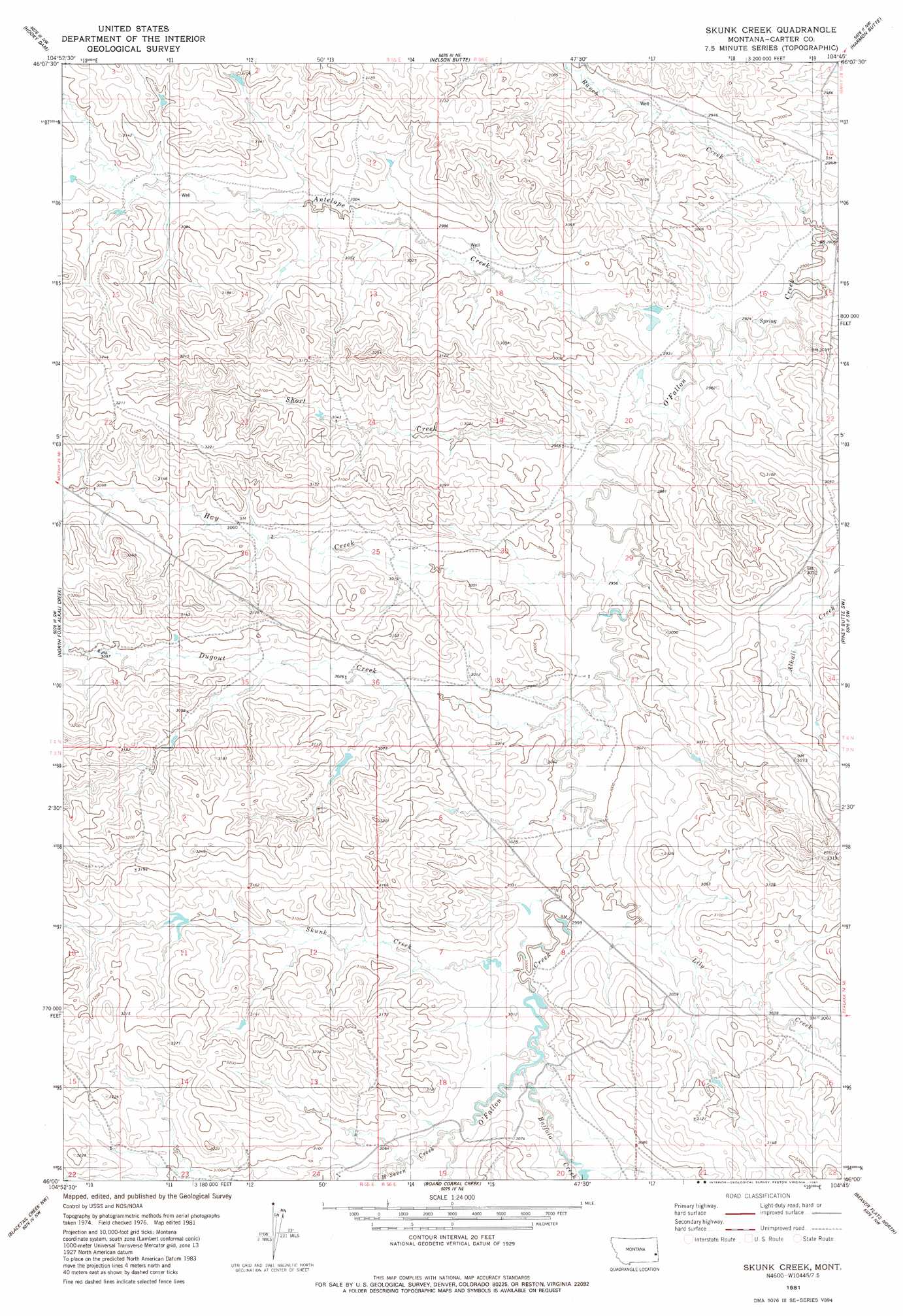
USGS Topo Quad 46104a7 - 1:24,000 scale
| Topo Map Name: | Skunk Creek |
| USGS Topo Quad ID: | 46104a7 |
| Print Size: | ca. 21 1/4" wide x 27" high |
| Southeast Coordinates: | 46° N latitude / 104.75° W longitude |
| Map Center Coordinates: | 46.0625° N latitude / 104.8125° W longitude |
| U.S. State: | MT |
| Filename: | o46104a7.jpg |
| Download Map JPG Image: | Skunk Creek topo map 1:24,000 scale |
| Map Type: | Topographic |
| Topo Series: | 7.5´ |
| Map Scale: | 1:24,000 |
| Source of Map Images: | United States Geological Survey (USGS) |
| Alternate Map Versions: |
Skunk Creek MT 1981, updated 1981 Download PDF Buy paper map Skunk Creek MT 2011 Download PDF Buy paper map Skunk Creek MT 2014 Download PDF Buy paper map |
1:24,000 Topo Quads surrounding Skunk Creek
Knowlton |
Foundation Spring |
Bracket Butte Se |
T G Creek |
Little Pine Creek |
Tepee Butte Ne |
Hooky Dam |
Nelson Butte |
Harmon Butte |
Seven-Up Butte |
Tepee Butte |
North Fork Alkali Creek |
Skunk Creek |
Piney Butte Sw |
Piney Butte |
Mills Creek East |
Blacktail Creek Nw |
Board Corral Creek |
Beaver Flats North |
Ekalaka |
Powderville |
Blacktail Creek Sw |
Blacktail Creek Se |
Beaver Flats South |
Stagville Draw |
> Back to 46104a1 at 1:100,000 scale
> Back to 46104a1 at 1:250,000 scale
> Back to U.S. Topo Maps home
Skunk Creek topo map: Gazetteer
Skunk Creek: Post Offices
Gilman Ranch Post Office (historical) elevation 919m 3015′Teedee Post Office (historical) elevation 948m 3110′
Skunk Creek: Streams
Antelope Creek elevation 895m 2936′Buffalo Creek elevation 923m 3028′
Dugout Creek elevation 911m 2988′
H Seven Creek elevation 928m 3044′
Hay Creek elevation 899m 2949′
Lily Creek elevation 916m 3005′
Ranch Creek elevation 892m 2926′
Short Creek elevation 896m 2939′
Skunk Creek elevation 921m 3021′
Skunk Creek: Wells
03N55E02CC__01 Well elevation 967m 3172′03N55E23AAAA01 Well elevation 949m 3113′
04N55E25ACD_01 Well elevation 933m 3061′
04N55E25ACD_02 Well elevation 933m 3061′
04N55E34BACD01 Well elevation 945m 3100′
27N54E07BACD01 Well elevation 958m 3143′
Skunk Creek digital topo map on disk
Buy this Skunk Creek topo map showing relief, roads, GPS coordinates and other geographical features, as a high-resolution digital map file on DVD:
Eastern Montana & Western North Dakota
Buy digital topo maps: Eastern Montana & Western North Dakota