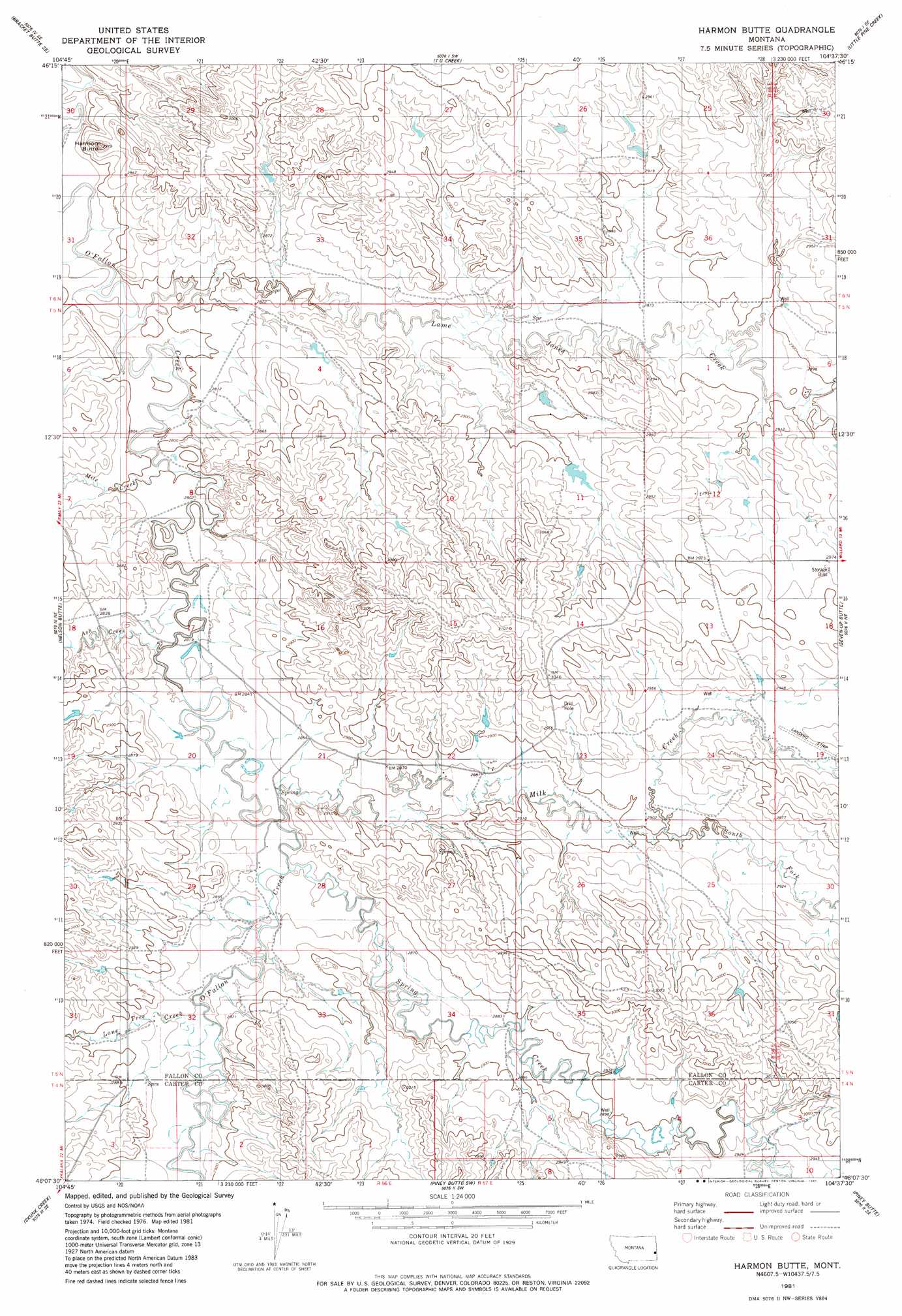
Harmon Butte Topo Map Montana
To zoom in, hover over the map of Harmon Butte
USGS Topo Quad 46104b6 - 1:24,000 scale
| Topo Map Name: | Harmon Butte |
| USGS Topo Quad ID: | 46104b6 |
| Print Size: | ca. 21 1/4" wide x 27" high |
| Southeast Coordinates: | 46.125° N latitude / 104.625° W longitude |
| Map Center Coordinates: | 46.1875° N latitude / 104.6875° W longitude |
| U.S. State: | MT |
| Filename: | o46104b6.jpg |
| Download Map JPG Image: | Harmon Butte topo map 1:24,000 scale |
| Map Type: | Topographic |
| Topo Series: | 7.5´ |
| Map Scale: | 1:24,000 |
| Source of Map Images: | United States Geological Survey (USGS) |
| Alternate Map Versions: |
Harmon Butte MT 1981, updated 1981 Download PDF Buy paper map Harmon Butte MT 2011 Download PDF Buy paper map Harmon Butte MT 2014 Download PDF Buy paper map |
1:24,000 Topo Quads surrounding Harmon Butte
Bracket Butte |
Ismay South |
Westmore |
Plevna |
Baker Nw |
Foundation Spring |
Bracket Butte Se |
T G Creek |
Little Pine Creek |
South Sandstone Reservoir |
Hooky Dam |
Nelson Butte |
Harmon Butte |
Seven-Up Butte |
Sportsman Pond |
North Fork Alkali Creek |
Skunk Creek |
Piney Butte Sw |
Piney Butte |
Medicine Rocks State Park |
Blacktail Creek Nw |
Board Corral Creek |
Beaver Flats North |
Ekalaka |
Terrell Creek |
> Back to 46104a1 at 1:100,000 scale
> Back to 46104a1 at 1:250,000 scale
> Back to U.S. Topo Maps home
Harmon Butte topo map: Gazetteer
Harmon Butte: Dams
7-UP Sea Dam elevation 890m 2919′Harmon Butte: Populated Places
MacKenzie (historical) elevation 868m 2847′Harmon Butte: Post Offices
MacKenzie Post Office (historical) elevation 868m 2847′Harmon Butte: Streams
Ash Creek elevation 866m 2841′Lame Jones Creek elevation 846m 2775′
Lone Tree Creek elevation 872m 2860′
Mile Creek elevation 852m 2795′
Milk Creek elevation 867m 2844′
South Fork Milk Creek elevation 886m 2906′
Spring Creek elevation 870m 2854′
Harmon Butte: Summits
Harmon Butte elevation 878m 2880′Harmon Butte: Wells
05N56E02BB__01 Well elevation 869m 2851′05N56E04BCB_01 Well elevation 869m 2851′
05N56E08BA__01 Well elevation 854m 2801′
05N56E17DD__01 Well elevation 868m 2847′
05N56E22DABB01 Well elevation 881m 2890′
05N56E22DB__01 Well elevation 894m 2933′
05N56E22DC__01 Well elevation 877m 2877′
05N56E24ABBB01 Well elevation 893m 2929′
05N56E24ADAD01 Well elevation 897m 2942′
05N56E31DAD_01 Well elevation 887m 2910′
05N56E32CBB_01 Well elevation 886m 2906′
05N56E36BAB_01 Well elevation 910m 2985′
05N57E18BAAB01 Well elevation 896m 2939′
Harmon Butte digital topo map on disk
Buy this Harmon Butte topo map showing relief, roads, GPS coordinates and other geographical features, as a high-resolution digital map file on DVD:
Eastern Montana & Western North Dakota
Buy digital topo maps: Eastern Montana & Western North Dakota