Westmore Topo Map Montana
To zoom in, hover over the map of Westmore
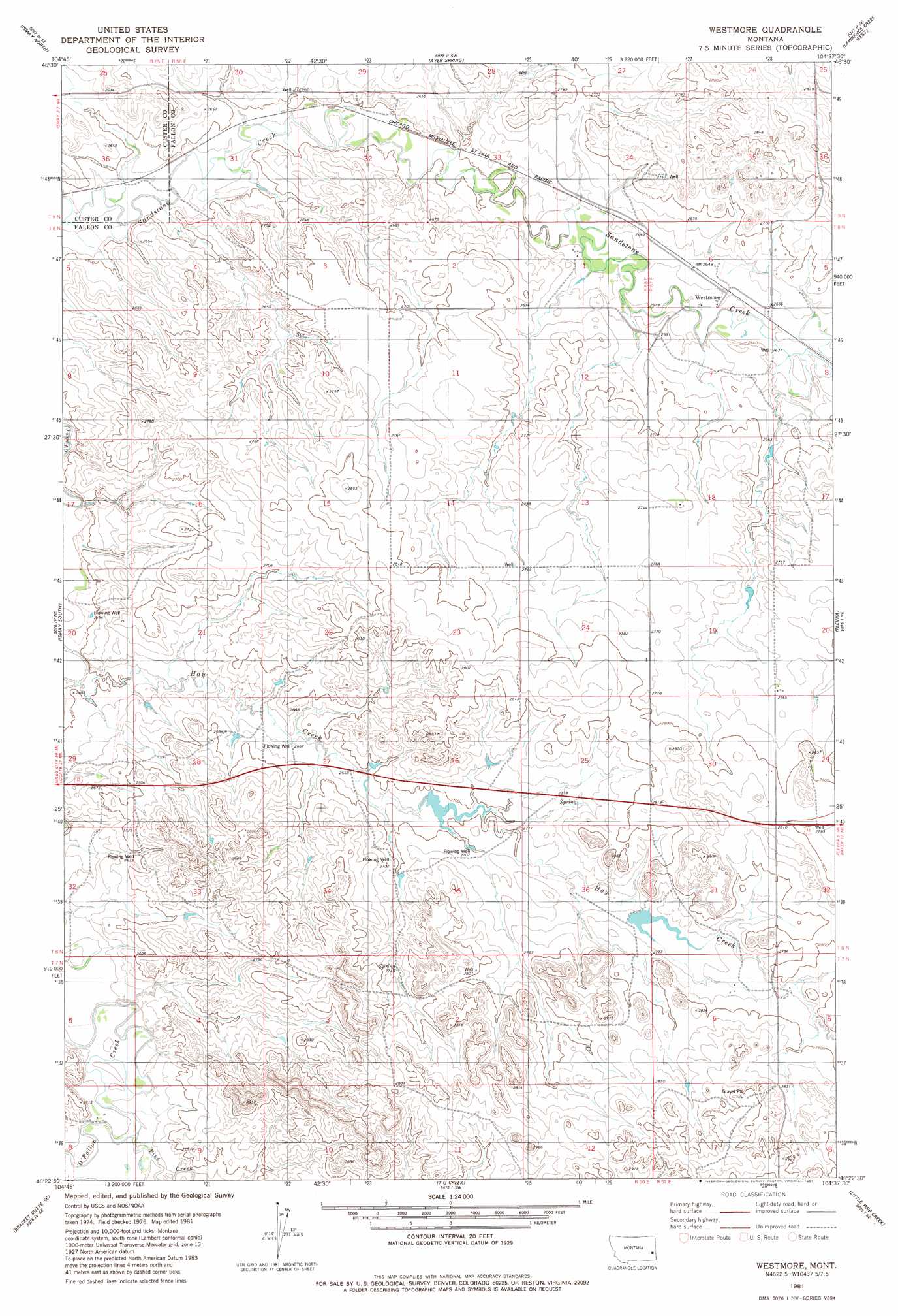
USGS Topo Quad 46104d6 - 1:24,000 scale
| Topo Map Name: | Westmore |
| USGS Topo Quad ID: | 46104d6 |
| Print Size: | ca. 21 1/4" wide x 27" high |
| Southeast Coordinates: | 46.375° N latitude / 104.625° W longitude |
| Map Center Coordinates: | 46.4375° N latitude / 104.6875° W longitude |
| U.S. State: | MT |
| Filename: | o46104d6.jpg |
| Download Map JPG Image: | Westmore topo map 1:24,000 scale |
| Map Type: | Topographic |
| Topo Series: | 7.5´ |
| Map Scale: | 1:24,000 |
| Source of Map Images: | United States Geological Survey (USGS) |
| Alternate Map Versions: |
Westmore MT 1981, updated 1981 Download PDF Buy paper map Westmore MT 2011 Download PDF Buy paper map Westmore MT 2014 Download PDF Buy paper map |
1:24,000 Topo Quads surrounding Westmore
Mildred |
Mildred Ne |
Dorothy Draw |
Ayer Spring Ne |
Rocking Chair Butte |
Loony Hollow |
Ismay North |
Ayer Spring |
Lawrence Creek West |
Lawrence Creek East |
Bracket Butte |
Ismay South |
Westmore |
Plevna |
Baker Nw |
Foundation Spring |
Bracket Butte Se |
T G Creek |
Little Pine Creek |
South Sandstone Reservoir |
Hooky Dam |
Nelson Butte |
Harmon Butte |
Seven-Up Butte |
Sportsman Pond |
> Back to 46104a1 at 1:100,000 scale
> Back to 46104a1 at 1:250,000 scale
> Back to U.S. Topo Maps home
Westmore topo map: Gazetteer
Westmore: Dams
Ehret Land Reservoir Dam elevation 864m 2834′Westmore: Populated Places
Westmore elevation 809m 2654′Westmore: Post Offices
Westmore Post Office (historical) elevation 811m 2660′Westmore: Streams
Pine Creek elevation 806m 2644′Westmore: Wells
07N57E06AC__01 Well elevation 844m 2769′08N56E01BB__01 Well elevation 808m 2650′
08N56E01CAAD01 Well elevation 804m 2637′
08N56E10AB__01 Well elevation 838m 2749′
08N56E15AD__01 Well elevation 855m 2805′
08N56E25DC__01 Well elevation 845m 2772′
08N56E27BCDA01 Well elevation 813m 2667′
08N56E29AC__01 Well elevation 801m 2627′
08N56E29CDA_01 Well elevation 814m 2670′
08N56E34ACA_01 Well elevation 846m 2775′
08N57E05CCAD01 Well elevation 821m 2693′
08N57E06CDDC01 Well elevation 807m 2647′
08N57E06DBCA01 Well elevation 815m 2673′
08N57E18BC__01 Well elevation 844m 2769′
08N57E20CC__01 Well elevation 850m 2788′
08N57E32BA__01 Well elevation 853m 2798′
09N55E25CD__01 Well elevation 800m 2624′
09N55E25DC__01 Well elevation 815m 2673′
09N56E28DDBC01 Well elevation 814m 2670′
09N56E30DDDD01 Well elevation 798m 2618′
09N56E31DA__01 Well elevation 804m 2637′
Westmore digital topo map on disk
Buy this Westmore topo map showing relief, roads, GPS coordinates and other geographical features, as a high-resolution digital map file on DVD:
Eastern Montana & Western North Dakota
Buy digital topo maps: Eastern Montana & Western North Dakota