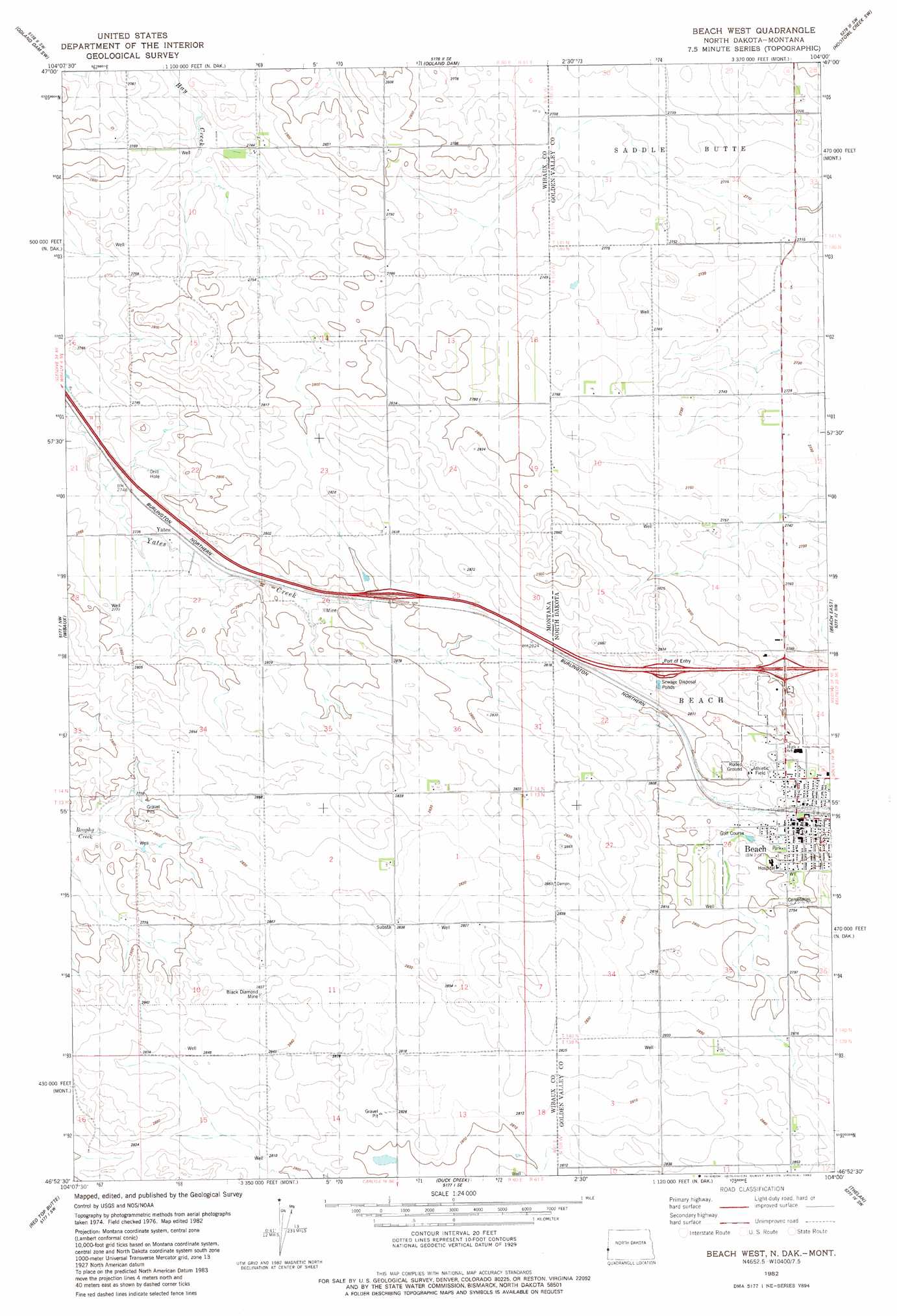
Beach West Topo Map Montana
To zoom in, hover over the map of Beach West
USGS Topo Quad 46104h1 - 1:24,000 scale
| Topo Map Name: | Beach West |
| USGS Topo Quad ID: | 46104h1 |
| Print Size: | ca. 21 1/4" wide x 27" high |
| Southeast Coordinates: | 46.875° N latitude / 104° W longitude |
| Map Center Coordinates: | 46.9375° N latitude / 104.0625° W longitude |
| U.S. States: | MT, ND |
| Filename: | o46104h1.jpg |
| Download Map JPG Image: | Beach West topo map 1:24,000 scale |
| Map Type: | Topographic |
| Topo Series: | 7.5´ |
| Map Scale: | 1:24,000 |
| Source of Map Images: | United States Geological Survey (USGS) |
| Alternate Map Versions: |
Beach West ND 1982, updated 1982 Download PDF Buy paper map Beach West ND 2011 Download PDF Buy paper map Beach West ND 2014 Download PDF Buy paper map |
1:24,000 Topo Quads surrounding Beach West
Cluster Buttes |
Odland Dam Nw |
Odland Dam Ne |
Hootowl Creek West |
Hootowl Creek East |
Cluster Buttes Se |
Odland Dam Sw |
Odland Dam |
Hootowl Creek Sw |
West Twin Butte |
Freeman Creek |
Wibaux |
Beach West |
Beach East |
Sentinel Butte |
Hodges Se |
Red Top Butte |
Duck Creek |
Thelan |
Sentinel Butte Se |
Cap Rock |
Carlyle Nw |
Carlyle |
Golva |
Alpha |
> Back to 46104e1 at 1:100,000 scale
> Back to 46104a1 at 1:250,000 scale
> Back to U.S. Topo Maps home
Beach West topo map: Gazetteer
Beach West: Crossings
Interchange 248 elevation 859m 2818′Beach West: Mines
Black Diamond Mine elevation 862m 2828′Black Diamond Mine elevation 866m 2841′
Beach West: Populated Places
Beach elevation 845m 2772′Beach West: Post Offices
Yates Post Office (historical) elevation 838m 2749′Beach West: Wells
13N60E11BBB_01 Well elevation 874m 2867′13N60E11DDD_01 Well elevation 859m 2818′
13N60E11DDD_02 Well elevation 859m 2818′
13N60E12BBC_01 Well elevation 861m 2824′
13N61E07DDD_01 Well elevation 861m 2824′
13N61E18CCA_01 Well elevation 857m 2811′
14_61_30AAA1__ Well elevation 873m 2864′
14N60E02CCC_01 Well elevation 852m 2795′
14N60E02DDDD01 Well elevation 860m 2821′
14N60E10BBBB01 Well elevation 845m 2772′
14N60E10DDD_01 Well elevation 848m 2782′
14N60E11BBB_01 Well elevation 837m 2746′
14N60E12DCC_01 Well elevation 842m 2762′
14N60E15DDD_01 Well elevation 858m 2814′
14N60E24BAA_01 Well elevation 854m 2801′
14N60E26ADBC01 Well elevation 861m 2824′
14N60E26BAA_01 Well elevation 871m 2857′
14N60E34CBAD01 Well elevation 869m 2851′
14N60E34CBBB01 Well elevation 865m 2837′
14N60E35BBB_02 Well elevation 861m 2824′
14N60E35DCC_01 Well elevation 870m 2854′
14N60E36CDCA01 Well elevation 859m 2818′
14N61E19AAA01_ Well elevation 843m 2765′
14N61E30AAA02_ Well elevation 873m 2864′
14N61E31ADD01_ Well elevation 872m 2860′
Beach West digital topo map on disk
Buy this Beach West topo map showing relief, roads, GPS coordinates and other geographical features, as a high-resolution digital map file on DVD:
Eastern Montana & Western North Dakota
Buy digital topo maps: Eastern Montana & Western North Dakota