Upper Magpie Reservoir Topo Map Montana
To zoom in, hover over the map of Upper Magpie Reservoir
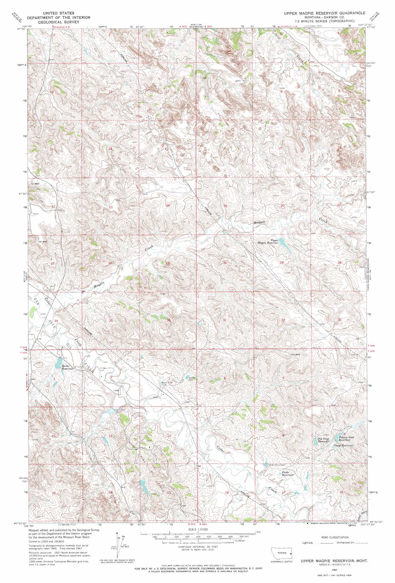
USGS Topo Quad 46104h6 - 1:24,000 scale
| Topo Map Name: | Upper Magpie Reservoir |
| USGS Topo Quad ID: | 46104h6 |
| Print Size: | ca. 21 1/4" wide x 27" high |
| Southeast Coordinates: | 46.875° N latitude / 104.625° W longitude |
| Map Center Coordinates: | 46.9375° N latitude / 104.6875° W longitude |
| U.S. State: | MT |
| Filename: | o46104h6.jpg |
| Download Map JPG Image: | Upper Magpie Reservoir topo map 1:24,000 scale |
| Map Type: | Topographic |
| Topo Series: | 7.5´ |
| Map Scale: | 1:24,000 |
| Source of Map Images: | United States Geological Survey (USGS) |
| Alternate Map Versions: |
Upper Magpie Reservoir MT 1967, updated 1970 Download PDF Buy paper map Upper Magpie Reservoir MT 2011 Download PDF Buy paper map Upper Magpie Reservoir MT 2014 Download PDF Buy paper map |
1:24,000 Topo Quads surrounding Upper Magpie Reservoir
Poverty Flat West |
Poverty Flat East |
Stipek |
Belle Prairie |
Cluster Buttes Nw |
Pleasant View |
Forest Park |
Glendive |
Allard |
Cluster Buttes Sw |
Marsh |
Hoyt |
Upper Magpie Reservoir |
Twin Forks Reservoir |
Hodges |
Marsh Sw |
Simons Butte |
Graveyard Hill Sw |
Graveyard Hill |
Hodges Sw |
Mildred |
Mildred Ne |
Dorothy Draw |
Ayer Spring Ne |
Rocking Chair Butte |
> Back to 46104e1 at 1:100,000 scale
> Back to 46104a1 at 1:250,000 scale
> Back to U.S. Topo Maps home
Upper Magpie Reservoir topo map: Gazetteer
Upper Magpie Reservoir: Dams
Bailer Reservoir Dam elevation 675m 2214′Basin View Dam elevation 691m 2267′
Ceder Bell Number 2 Dam elevation 715m 2345′
Dead Horse Dam elevation 697m 2286′
Gertison Dam elevation 680m 2230′
Gertison Dam elevation 680m 2230′
Juniper Dam elevation 708m 2322′
Prairie Goat Dam elevation 727m 2385′
Twin Buttes Retention Dam elevation 717m 2352′
Upper Magpie Reservoir Dam elevation 725m 2378′
Upper Prairie Goat Dam elevation 739m 2424′
Upper Magpie Reservoir: Oilfields
Gas City Oil Field elevation 661m 2168′North Pine Oil Field elevation 742m 2434′
Upper Magpie Reservoir: Reservoirs
Bailer Reservoir elevation 672m 2204′Big Drop Reservoir elevation 728m 2388′
Camp Reservoir elevation 725m 2378′
Forks Reservoir elevation 703m 2306′
Prairie Goat Reservoir elevation 728m 2388′
Upper Magpie Reservoir elevation 708m 2322′
Upper Magpie Reservoir: Streams
Magpie Creek elevation 659m 2162′Upper Magpie Reservoir: Valleys
Abbot Draw elevation 686m 2250′Upper Magpie Reservoir: Wells
13N56E30CCBC01 Well elevation 718m 2355′14N55E27CD__01 Well elevation 678m 2224′
14N55E27CDDB01 Well elevation 678m 2224′
14N56E09ADDB01 Well elevation 766m 2513′
14N56E21ABAD01 Well elevation 731m 2398′
Upper Magpie Reservoir digital topo map on disk
Buy this Upper Magpie Reservoir topo map showing relief, roads, GPS coordinates and other geographical features, as a high-resolution digital map file on DVD:
Eastern Montana & Western North Dakota
Buy digital topo maps: Eastern Montana & Western North Dakota