Bear Jaw Creek Topo Map Montana
To zoom in, hover over the map of Bear Jaw Creek
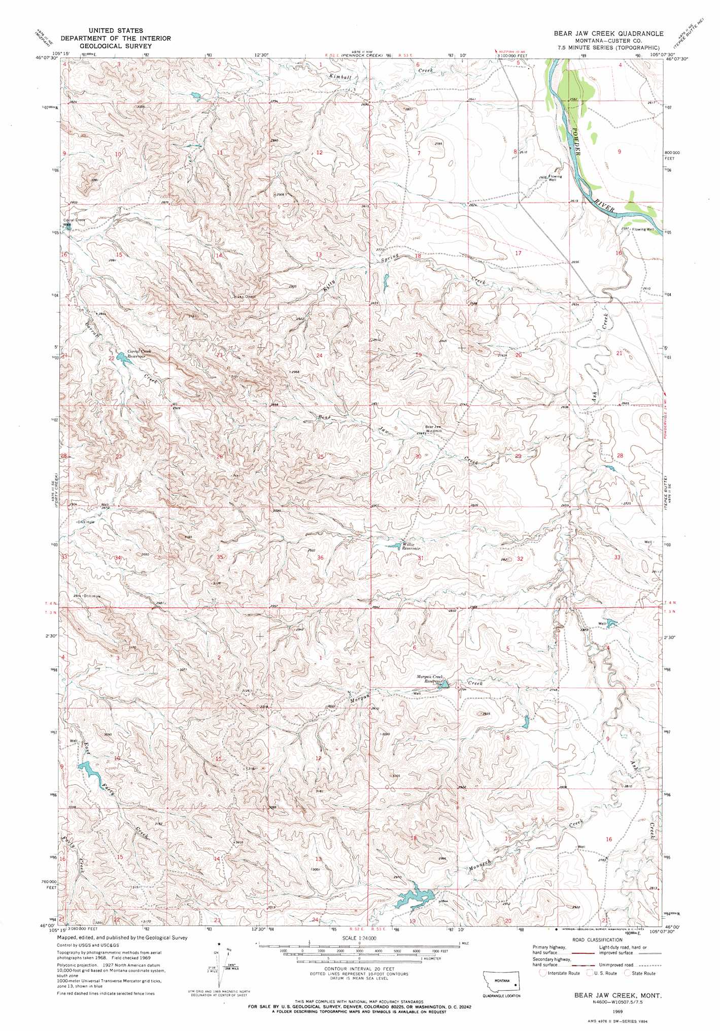
USGS Topo Quad 46105a2 - 1:24,000 scale
| Topo Map Name: | Bear Jaw Creek |
| USGS Topo Quad ID: | 46105a2 |
| Print Size: | ca. 21 1/4" wide x 27" high |
| Southeast Coordinates: | 46° N latitude / 105.125° W longitude |
| Map Center Coordinates: | 46.0625° N latitude / 105.1875° W longitude |
| U.S. State: | MT |
| Filename: | o46105a2.jpg |
| Download Map JPG Image: | Bear Jaw Creek topo map 1:24,000 scale |
| Map Type: | Topographic |
| Topo Series: | 7.5´ |
| Map Scale: | 1:24,000 |
| Source of Map Images: | United States Geological Survey (USGS) |
| Alternate Map Versions: |
Bear Jaw Creek MT 1969, updated 1973 Download PDF Buy paper map Bear Jaw Creek MT 2011 Download PDF Buy paper map Bear Jaw Creek MT 2014 Download PDF Buy paper map |
1:24,000 Topo Quads surrounding Bear Jaw Creek
Locate Sw |
Locate Se |
Red Knob |
Knowlton |
Foundation Spring |
Loaf Of Bread Butte |
Mizpah |
Pennock Creek |
Tepee Butte Ne |
Hooky Dam |
Miles City Creek |
Forty Creek |
Bear Jaw Creek |
Tepee Butte |
North Fork Alkali Creek |
Saddle Horse Butte |
Maxwell Butte |
Mills Creek West |
Mills Creek East |
Blacktail Creek Nw |
Witcher Reservoir |
Rattlesnake Hill |
Snake Butte |
Powderville |
Blacktail Creek Sw |
> Back to 46105a1 at 1:100,000 scale
> Back to 46104a1 at 1:250,000 scale
> Back to U.S. Topo Maps home
Bear Jaw Creek topo map: Gazetteer
Bear Jaw Creek: Dams
E Hardy Number 2 Dam elevation 864m 2834′Leidholt Reservoir Dam elevation 897m 2942′
Bear Jaw Creek: Reservoirs
Corral Creek Reservoir elevation 864m 2834′Morgan Creek Reservoir elevation 847m 2778′
Willie Reservoir elevation 843m 2765′
Bear Jaw Creek: Streams
Ash Creek elevation 787m 2582′Bear Jaw Creek elevation 804m 2637′
Kitty Spring Creek elevation 792m 2598′
Monarch Creek elevation 828m 2716′
Morgan Creek elevation 815m 2673′
Bear Jaw Creek: Wells
03N52E12BD__01 Well elevation 803m 2634′03S52E13CCC_01 Well elevation 914m 2998′
04N52E01DDBD01 Well elevation 819m 2687′
04N52E16AADD01 Well elevation 846m 2775′
04N53E21BAA_01 Well elevation 790m 2591′
04N53E30ACBA01 Well elevation 840m 2755′
Corral Creek Well elevation 846m 2775′
Bear Jaw Creek digital topo map on disk
Buy this Bear Jaw Creek topo map showing relief, roads, GPS coordinates and other geographical features, as a high-resolution digital map file on DVD:
Eastern Montana & Western North Dakota
Buy digital topo maps: Eastern Montana & Western North Dakota