Miles City Topo Map Montana
To zoom in, hover over the map of Miles City
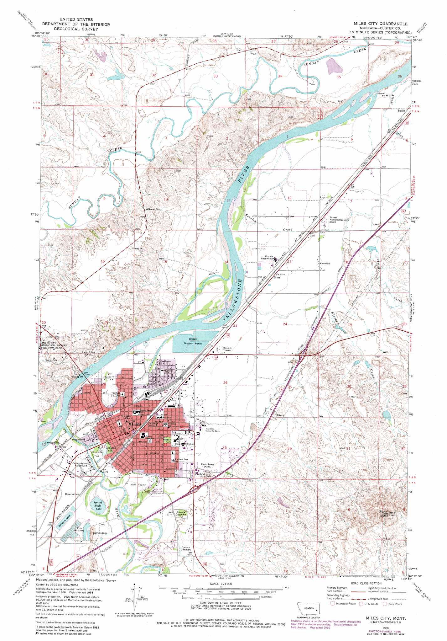
USGS Topo Quad 46105d7 - 1:24,000 scale
| Topo Map Name: | Miles City |
| USGS Topo Quad ID: | 46105d7 |
| Print Size: | ca. 21 1/4" wide x 27" high |
| Southeast Coordinates: | 46.375° N latitude / 105.75° W longitude |
| Map Center Coordinates: | 46.4375° N latitude / 105.8125° W longitude |
| U.S. State: | MT |
| Filename: | o46105d7.jpg |
| Download Map JPG Image: | Miles City topo map 1:24,000 scale |
| Map Type: | Topographic |
| Topo Series: | 7.5´ |
| Map Scale: | 1:24,000 |
| Source of Map Images: | United States Geological Survey (USGS) |
| Alternate Map Versions: |
Miles City MT 1968, updated 1972 Download PDF Buy paper map Miles City MT 1968, updated 1980 Download PDF Buy paper map Miles City MT 2011 Download PDF Buy paper map Miles City MT 2014 Download PDF Buy paper map |
1:24,000 Topo Quads surrounding Miles City
Angela Ne |
Horse Creek Hill |
Coal Bank Spring |
Kinsey Nw |
Kinsey Ne |
N Bar Coulee |
Deadman Creek |
Noble Reservoir |
Kinsey |
Shirley |
Butterfly Creek |
Big Hill |
Miles City |
Government Hill |
The Knob |
Horton |
Lignite Creek |
Paddy Fay Creek |
Whitney Creek |
Government Hill Se |
Moon Creek School |
Jack Creek Nw |
Circle L Creek |
Horse Creek |
First Creek |
> Back to 46105a1 at 1:100,000 scale
> Back to 46104a1 at 1:250,000 scale
> Back to U.S. Topo Maps home
Miles City topo map: Gazetteer
Miles City: Airports
Sunday Creek Airpark elevation 753m 2470′Miles City: Bridges
Kircher Creek Bridge elevation 741m 2431′Tongue River Bridge elevation 718m 2355′
Miles City: Canals
Tongue and Yellowstone River Irrigation District Canal elevation 731m 2398′Miles City: Crossings
Interchange 138 elevation 735m 2411′Interchange 141 elevation 738m 2421′
Miles City: Dams
Branum Lake Dam elevation 722m 2368′Glasscock Number 2 Dam elevation 730m 2395′
Goodale Number 2 Dam elevation 742m 2434′
Hogan Number 2 Dam elevation 757m 2483′
Miles City Sewage Disposal Pond Number 1 Dam elevation 719m 2358′
Miles City Sewage Disposal Pond Number 2 Dam elevation 715m 2345′
Miles City Sewage Disposal Pond Number 3 Dam elevation 715m 2345′
Miles City: Islands
Pirogue Island elevation 716m 2349′Miles City: Lakes
Cook Lake elevation 722m 2368′Scanlan Lake elevation 717m 2352′
Miles City: Parks
Bender Park elevation 721m 2365′Denton Field elevation 725m 2378′
Pirogue Island State Park elevation 716m 2349′
Pumping Plant Park elevation 723m 2372′
Riverside Park elevation 723m 2372′
Spotted Eagle Recreation Area elevation 725m 2378′
Tedesco Park elevation 725m 2378′
Tongue River Historical Marker elevation 724m 2375′
Triangle Park elevation 721m 2365′
Wibaux Park elevation 724m 2375′
Wild Rose Park elevation 745m 2444′
Miles City: Populated Places
Carbon Hill Trailer Court elevation 729m 2391′Cope Trailer Park elevation 726m 2381′
Green Star Trailer Court elevation 722m 2368′
Miles City elevation 722m 2368′
Smiths Trailer Court elevation 722m 2368′
Tusler elevation 712m 2335′
Valley Drive Mobile Home Park elevation 723m 2372′
Westwood Estates elevation 720m 2362′
Miles City: Post Offices
Miles City Post Office elevation 720m 2362′Miles City: Reservoirs
Branum Lake elevation 722m 2368′Spotted Eagle Lake elevation 718m 2355′
Miles City: Streams
Alkali Creek elevation 705m 2312′Bensley Creek elevation 708m 2322′
Cow Creek elevation 715m 2345′
Kircher Creek elevation 708m 2322′
Tongue River elevation 714m 2342′
Tongue River elevation 718m 2355′
Miles City: Summits
Camelsback elevation 756m 2480′Carbon Hill elevation 768m 2519′
Signal Butte elevation 930m 3051′
Miles City: Wells
07N47E04BABA01 Well elevation 722m 2368′07N47E08AAA_01 Well elevation 725m 2378′
07N47E09BAA_01 Well elevation 729m 2391′
07N47E09BBB_01 Well elevation 726m 2381′
07N47E10ADAA01 Well elevation 739m 2424′
07N47E24BCDD01 Well elevation 780m 2559′
08N47E13AABD01 Well elevation 720m 2362′
08N47E20DBAC01 Well elevation 809m 2654′
08N47E32ACD_01 Well elevation 724m 2375′
09N47E35ABAD01 Well elevation 711m 2332′
09N47E35ADCD01 Well elevation 714m 2342′
Miles City digital topo map on disk
Buy this Miles City topo map showing relief, roads, GPS coordinates and other geographical features, as a high-resolution digital map file on DVD:
Eastern Montana & Western North Dakota
Buy digital topo maps: Eastern Montana & Western North Dakota