Flat Top Butte Sw Topo Map Montana
To zoom in, hover over the map of Flat Top Butte Sw
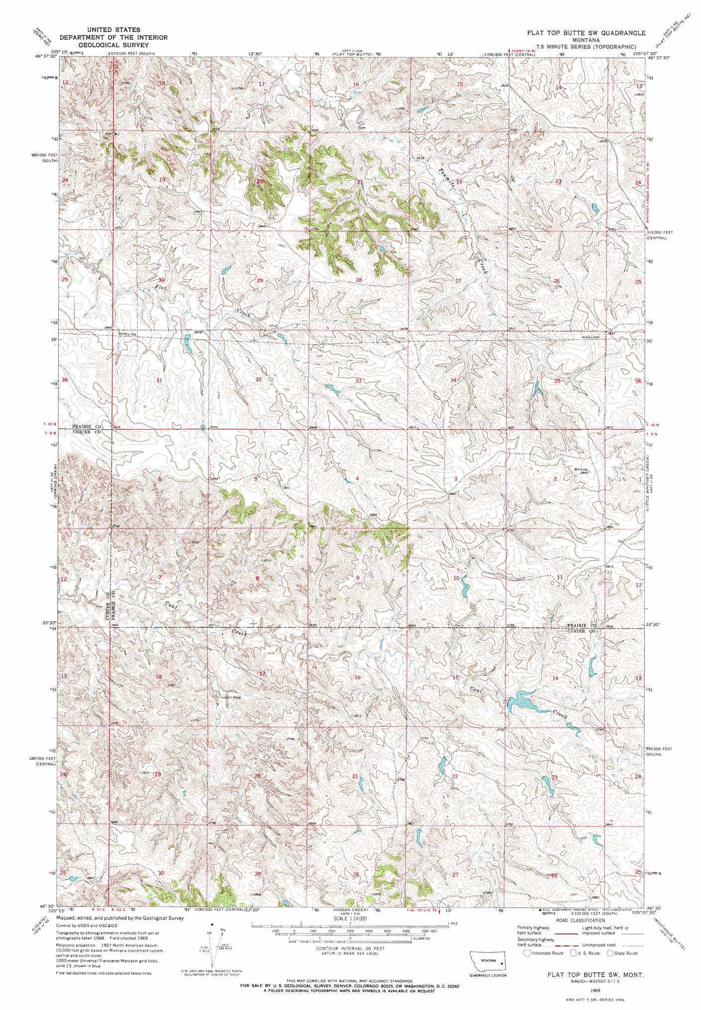
USGS Topo Quad 46105e2 - 1:24,000 scale
| Topo Map Name: | Flat Top Butte Sw |
| USGS Topo Quad ID: | 46105e2 |
| Print Size: | ca. 21 1/4" wide x 27" high |
| Southeast Coordinates: | 46.5° N latitude / 105.125° W longitude |
| Map Center Coordinates: | 46.5625° N latitude / 105.1875° W longitude |
| U.S. State: | MT |
| Filename: | o46105e2.jpg |
| Download Map JPG Image: | Flat Top Butte Sw topo map 1:24,000 scale |
| Map Type: | Topographic |
| Topo Series: | 7.5´ |
| Map Scale: | 1:24,000 |
| Source of Map Images: | United States Geological Survey (USGS) |
| Alternate Map Versions: |
Flat Top Butte SW MT 1969, updated 1973 Download PDF Buy paper map Flat Top Butte SW MT 2011 Download PDF Buy paper map Flat Top Butte SW MT 2014 Download PDF Buy paper map |
1:24,000 Topo Quads surrounding Flat Top Butte Sw
Calypso |
Terry |
Fallon Sw |
Fallon |
Marsh Sw |
Zero |
Zero Ne |
Flat Top Butte |
Flat Top Butte Ne |
Mildred |
Corral Butte |
Spring Draw |
Flat Top Butte Sw |
Little Whitney Creek |
Loony Hollow |
Buck Mountain |
Locate |
Hogan Creek |
Montague Butte |
Bracket Butte |
Locate Sw |
Locate Se |
Red Knob |
Knowlton |
Foundation Spring |
> Back to 46105e1 at 1:100,000 scale
> Back to 46104a1 at 1:250,000 scale
> Back to U.S. Topo Maps home
Flat Top Butte Sw topo map: Gazetteer
Flat Top Butte Sw: Dams
Beardsley Number 1 Dam elevation 850m 2788′Beardsley Number 7 Dam elevation 824m 2703′
Coal Creek Dam Number 1 elevation 861m 2824′
Olson Dam elevation 813m 2667′
Flat Top Butte Sw: Post Offices
Barrial Post Office (historical) elevation 869m 2851′Flat Top Butte Sw: Wells
09N52E05CACC01 Well elevation 847m 2778′10N52E19DBBB01 Well elevation 849m 2785′
Flat Top Butte Sw digital topo map on disk
Buy this Flat Top Butte Sw topo map showing relief, roads, GPS coordinates and other geographical features, as a high-resolution digital map file on DVD:
Eastern Montana & Western North Dakota
Buy digital topo maps: Eastern Montana & Western North Dakota