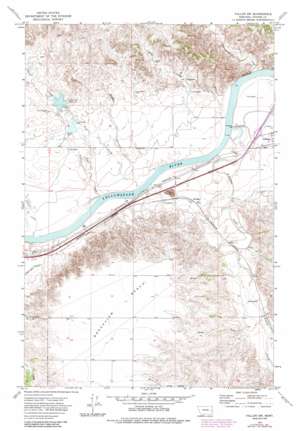
Fallon Sw Topo Map Montana
To zoom in, hover over the map of Fallon Sw
USGS Topo Quad 46105g2 - 1:24,000 scale
| Topo Map Name: | Fallon Sw |
| USGS Topo Quad ID: | 46105g2 |
| Print Size: | ca. 21 1/4" wide x 27" high |
| Southeast Coordinates: | 46.75° N latitude / 105.125° W longitude |
| Map Center Coordinates: | 46.8125° N latitude / 105.1875° W longitude |
| U.S. State: | MT |
| Filename: | o46105g2.jpg |
| Download Map JPG Image: | Fallon Sw topo map 1:24,000 scale |
| Map Type: | Topographic |
| Topo Series: | 7.5´ |
| Map Scale: | 1:24,000 |
| Source of Map Images: | United States Geological Survey (USGS) |
| Alternate Map Versions: |
Fallon SW MT 1972, updated 1976 Download PDF Buy paper map Fallon SW MT 1972, updated 1985 Download PDF Buy paper map Fallon SW MT 2011 Download PDF Buy paper map Fallon SW MT 2014 Download PDF Buy paper map |
1:24,000 Topo Quads surrounding Fallon Sw
> Back to 46105e1 at 1:100,000 scale
> Back to 46104a1 at 1:250,000 scale
> Back to U.S. Topo Maps home
Fallon Sw topo map: Gazetteer
Fallon Sw: Benches
Broadview Bench elevation 774m 2539′Fallon Sw: Crossings
Interchange 185 elevation 669m 2194′Fallon Sw: Dams
Coal Creek Dam elevation 699m 2293′Coal Creek Drop Dam elevation 692m 2270′
Resettlement FSA Number 4 Dam elevation 681m 2234′
Fallon Sw: Populated Places
Bluffport elevation 687m 2253′Fallon Sw: Rapids
White Island Rapids elevation 647m 2122′Fallon Sw: Reservoirs
Coal Creek Reservoir elevation 699m 2293′Fallon Sw: Streams
Brights Valley Creek elevation 688m 2257′Cameron Creek elevation 689m 2260′
Cherry Creek elevation 664m 2178′
Coal Creek elevation 661m 2168′
Cottonwood Creek elevation 649m 2129′
Deer Creek elevation 659m 2162′
Johnson Creek elevation 670m 2198′
Newman Hollow Creek elevation 674m 2211′
O'Fallon Creek elevation 656m 2152′
Pine Creek elevation 647m 2122′
Fallon Sw: Valleys
Mamies Coulee elevation 684m 2244′Skunk Arroyo elevation 669m 2194′
Fallon Sw: Wells
12N51E12CDAD01 Well elevation 667m 2188′12N51E13DB__01 Well elevation 680m 2230′
12N52E04BBBB01 Well elevation 681m 2234′
12N52E06BAAA01 Well elevation 689m 2260′
12N52E18CB__01 Well elevation 684m 2244′
12N52E23DBAD01 Well elevation 676m 2217′
12N52E26BB__01 Well elevation 725m 2378′
12N52E26BCAB01 Well elevation 717m 2352′
13N51E34AADA01 Well elevation 708m 2322′
13N52E29BDBC01 Well elevation 702m 2303′
13N52E29CADB01 Well elevation 687m 2253′
13N52E30CBCA01 Well elevation 703m 2306′
13N52E32ADAA01 Well elevation 663m 2175′
13N52E33AC__01 Well elevation 668m 2191′
13N52E34CDBB01 Well elevation 675m 2214′
Fallon Sw digital topo map on disk
Buy this Fallon Sw topo map showing relief, roads, GPS coordinates and other geographical features, as a high-resolution digital map file on DVD:
Eastern Montana & Western North Dakota
Buy digital topo maps: Eastern Montana & Western North Dakota


