Mccloud Topo Map Montana
To zoom in, hover over the map of Mccloud
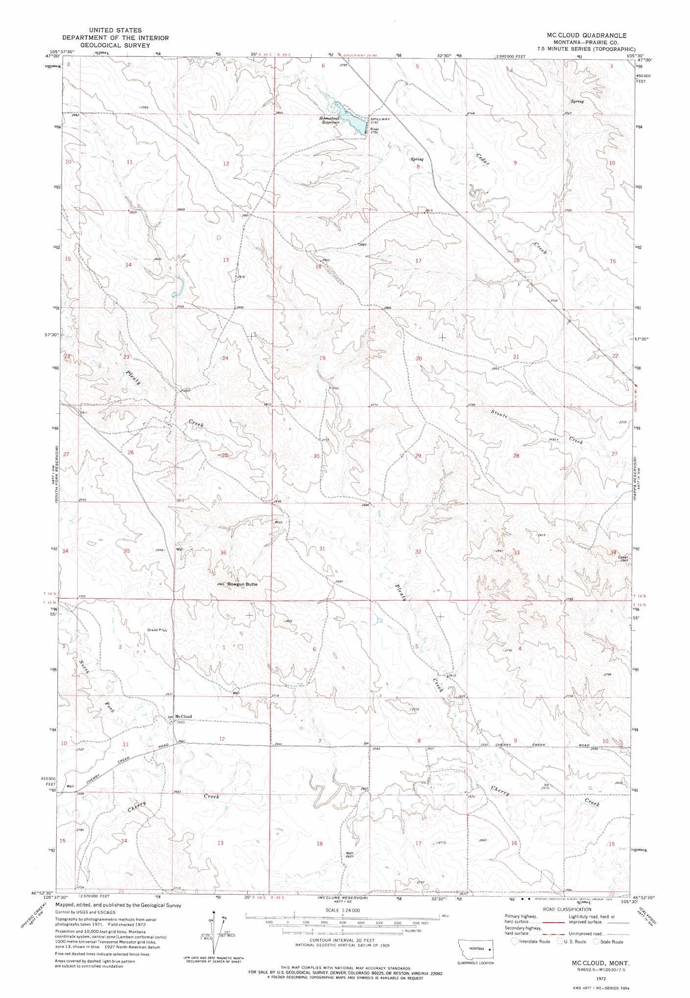
USGS Topo Quad 46105h5 - 1:24,000 scale
| Topo Map Name: | Mccloud |
| USGS Topo Quad ID: | 46105h5 |
| Print Size: | ca. 21 1/4" wide x 27" high |
| Southeast Coordinates: | 46.875° N latitude / 105.5° W longitude |
| Map Center Coordinates: | 46.9375° N latitude / 105.5625° W longitude |
| U.S. State: | MT |
| Filename: | o46105h5.jpg |
| Download Map JPG Image: | Mccloud topo map 1:24,000 scale |
| Map Type: | Topographic |
| Topo Series: | 7.5´ |
| Map Scale: | 1:24,000 |
| Source of Map Images: | United States Geological Survey (USGS) |
| Alternate Map Versions: |
Mc Cloud MT 1972, updated 1975 Download PDF Buy paper map McCloud MT 2011 Download PDF Buy paper map McCloud MT 2014 Download PDF Buy paper map |
1:24,000 Topo Quads surrounding Mccloud
Watkins |
Big Sheep Mountain Nw |
Bearshack Creek |
Diamond G Butte Nw |
Union School |
Watkins Se |
Big Sheep Mountain |
Becker Dam |
North Coulee |
Diamond G Butte |
Little Sheep Mountain |
South Fork Reservoir |
Mccloud |
Papps Reservoir |
Diamond G Creek |
Morehouse Creek |
Physic Creek |
Mcclure Reservoir |
Calypso |
Terry |
Coal Bank Spring |
Kinsey Nw |
Kinsey Ne |
Zero |
Zero Ne |
> Back to 46105e1 at 1:100,000 scale
> Back to 46104a1 at 1:250,000 scale
> Back to U.S. Topo Maps home
Mccloud topo map: Gazetteer
Mccloud: Dams
Homestead Dam elevation 836m 2742′Mccloud: Populated Places
McCloud elevation 817m 2680′Mccloud: Post Offices
Hazel Post Office (historical) elevation 841m 2759′Mccloud: Reservoirs
Homestead Reservoir elevation 836m 2742′Mccloud: Streams
North Fork Cherry Creek elevation 805m 2641′North Fork Plenty Creek elevation 803m 2634′
Plenty Creek elevation 783m 2568′
Mccloud: Summits
Bowgun Butte elevation 889m 2916′Mccloud: Valleys
Smith Coulee elevation 810m 2657′Mccloud: Wells
13N48E01DCCD01 Well elevation 823m 2700′13N49E08DDAA01 Well elevation 781m 2562′
13N49E18DBAD01 Well elevation 795m 2608′
14N49E21AAAA01 Well elevation 826m 2709′
14N49E28ADAC01 Well elevation 823m 2700′
Mccloud digital topo map on disk
Buy this Mccloud topo map showing relief, roads, GPS coordinates and other geographical features, as a high-resolution digital map file on DVD:
Eastern Montana & Western North Dakota
Buy digital topo maps: Eastern Montana & Western North Dakota