North Fork Crooked Creek East Topo Map Montana
To zoom in, hover over the map of North Fork Crooked Creek East
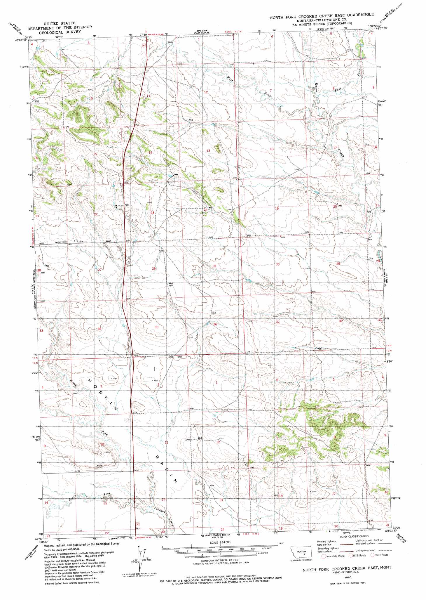
USGS Topo Quad 46108a4 - 1:24,000 scale
| Topo Map Name: | North Fork Crooked Creek East |
| USGS Topo Quad ID: | 46108a4 |
| Print Size: | ca. 21 1/4" wide x 27" high |
| Southeast Coordinates: | 46° N latitude / 108.375° W longitude |
| Map Center Coordinates: | 46.0625° N latitude / 108.4375° W longitude |
| U.S. State: | MT |
| Filename: | o46108a4.jpg |
| Download Map JPG Image: | North Fork Crooked Creek East topo map 1:24,000 scale |
| Map Type: | Topographic |
| Topo Series: | 7.5´ |
| Map Scale: | 1:24,000 |
| Source of Map Images: | United States Geological Survey (USGS) |
| Alternate Map Versions: |
North Fork Crooked Creek East MT 1980, updated 1980 Download PDF Buy paper map North Fork Crooked Creek East MT 2011 Download PDF Buy paper map North Fork Crooked Creek East MT 2014 Download PDF Buy paper map |
1:24,000 Topo Quads surrounding North Fork Crooked Creek East
Elso |
Harper Coulee |
Signal Mountain |
Dunn Mountain North |
Cherry Spring |
Hay Basin North |
Hay Basin Ne |
Park Coulee |
Dunn Mountain South |
P K Ranch |
Hay Basin South |
North Fork Crooked Creek West |
North Fork Crooked Creek East |
Cotton Creek |
P K Ranch Sw |
Acton |
Hickson Ranch |
Rattlesnake Butte |
Huntley |
Worden |
Rimrock |
Billings West |
Billings East |
Cottonwood Creek |
Indian Arrow |
> Back to 46108a1 at 1:100,000 scale
> Back to 46108a1 at 1:250,000 scale
> Back to U.S. Topo Maps home
North Fork Crooked Creek East topo map: Gazetteer
North Fork Crooked Creek East: Streams
East Fork Razor Creek elevation 1008m 3307′North Fork Crooked Creek elevation 971m 3185′
South Fork Crooked Creek elevation 971m 3185′
West Fork Razor Creek elevation 1003m 3290′
West Razor Creek elevation 994m 3261′
North Fork Crooked Creek East: Wells
03N26E12BBCD01 Well elevation 1003m 3290′03N26E12BCCD01 Well elevation 1004m 3293′
03N26E12DDDA01 Well elevation 1014m 3326′
03N26E14B___01 Well elevation 983m 3225′
03N27E08CCBC01 Well elevation 1032m 3385′
03N27E08CDDB01 Well elevation 1030m 3379′
04N26E02DADA01 Well elevation 1030m 3379′
04N26E22ADDB01 Well elevation 1101m 3612′
04N26E24D___01 Well elevation 1033m 3389′
04N27E05DDBD01 Well elevation 1030m 3379′
04N27E18DBDB01 Well elevation 1022m 3353′
04N27E29CBCB01 Well elevation 1001m 3284′
North Fork Crooked Creek East digital topo map on disk
Buy this North Fork Crooked Creek East topo map showing relief, roads, GPS coordinates and other geographical features, as a high-resolution digital map file on DVD: