Dunn Mountain North Topo Map Montana
To zoom in, hover over the map of Dunn Mountain North
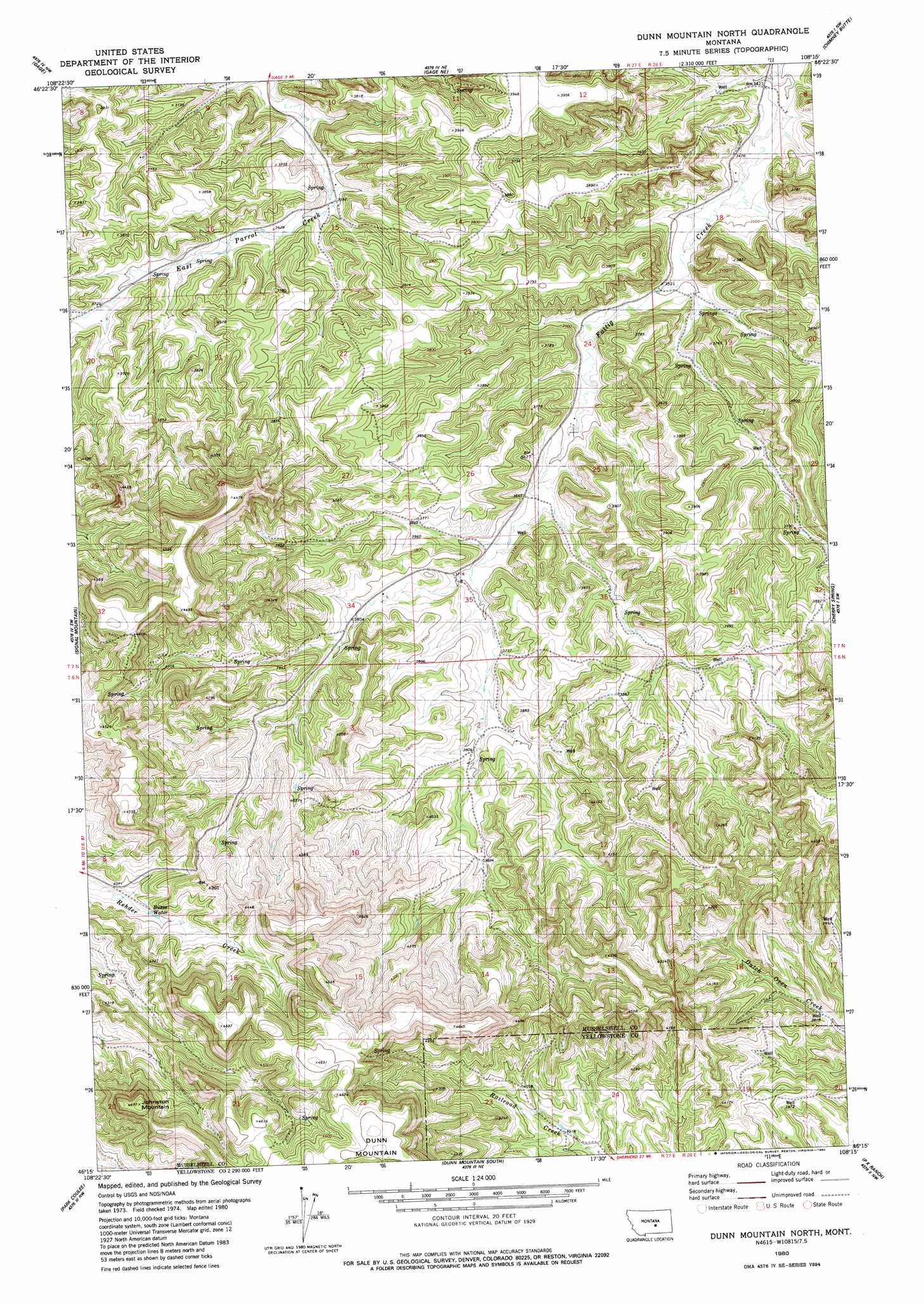
USGS Topo Quad 46108c3 - 1:24,000 scale
| Topo Map Name: | Dunn Mountain North |
| USGS Topo Quad ID: | 46108c3 |
| Print Size: | ca. 21 1/4" wide x 27" high |
| Southeast Coordinates: | 46.25° N latitude / 108.25° W longitude |
| Map Center Coordinates: | 46.3125° N latitude / 108.3125° W longitude |
| U.S. State: | MT |
| Filename: | o46108c3.jpg |
| Download Map JPG Image: | Dunn Mountain North topo map 1:24,000 scale |
| Map Type: | Topographic |
| Topo Series: | 7.5´ |
| Map Scale: | 1:24,000 |
| Source of Map Images: | United States Geological Survey (USGS) |
| Alternate Map Versions: |
Dunn Mountain North MT 1980, updated 1980 Download PDF Buy paper map Dunn Mountain North MT 2011 Download PDF Buy paper map Dunn Mountain North MT 2014 Download PDF Buy paper map |
1:24,000 Topo Quads surrounding Dunn Mountain North
Lake Mason Se |
Big Wall West |
Big Wall East |
Delphia |
Musselshell |
Roundup |
Gage |
Gage Ne |
Chimney Butte |
Corey Flat |
Harper Coulee |
Signal Mountain |
Dunn Mountain North |
Cherry Spring |
Steamboat Butte |
Hay Basin Ne |
Park Coulee |
Dunn Mountain South |
P K Ranch |
P K Ranch Ne |
North Fork Crooked Creek West |
North Fork Crooked Creek East |
Cotton Creek |
P K Ranch Sw |
P K Ranch Se |
> Back to 46108a1 at 1:100,000 scale
> Back to 46108a1 at 1:250,000 scale
> Back to U.S. Topo Maps home
Dunn Mountain North topo map: Gazetteer
Dunn Mountain North: Lakes
Busse Water elevation 1248m 4094′Dunn Mountain North: Populated Places
Fattig (historical) elevation 1062m 3484′Dunn Mountain North: Post Offices
Fattig Post Office (historical) elevation 1062m 3484′Dunn Mountain North: Ranges
Bull Mountains elevation 1172m 3845′Dunn Mountain North: Springs
06N27E02BCA_01 Spring elevation 1157m 3795′06N27E02DAB_01 Spring elevation 1166m 3825′
06N27E02DCB_01 Spring elevation 1171m 3841′
06N27E04ACC_01 Spring elevation 1210m 3969′
06N27E04BDD_01 Spring elevation 1231m 4038′
06N27E05ABC_01 Spring elevation 1314m 4311′
06N27E05ABD_01 Spring elevation 1280m 4199′
06N27E09ADC_01 Spring elevation 1252m 4107′
06N27E09BDD_01 Spring elevation 1246m 4087′
06N27E09DAD_01 Spring elevation 1286m 4219′
06N27E10AAD_01 Spring elevation 1192m 3910′
06N27E10ACC_01 Spring elevation 1237m 4058′
06N27E10BBB_01 Spring elevation 1221m 4005′
06N27E11CAA_01 Spring elevation 1198m 3930′
06N27E12BCD_01 Spring elevation 1196m 3923′
06N27E14BDC_01 Spring elevation 1256m 4120′
06N27E15AAA_01 Spring elevation 1244m 4081′
06N27E15CBD_01 Spring elevation 1358m 4455′
06N27E15CCC_01 Spring elevation 1362m 4468′
06N27E15DCA_01 Spring elevation 1355m 4445′
06N27E17AAA_01 Spring elevation 1246m 4087′
06N27E17ABAB01 Spring elevation 1257m 4124′
06N27E17ACC_01 Spring elevation 1240m 4068′
06N27E20AAB_01 Spring elevation 1269m 4163′
06N27E21ADD_01 Spring elevation 1359m 4458′
06N27E21BAC_01 Spring elevation 1308m 4291′
06N27E21BBA_01 Spring elevation 1287m 4222′
06N27E21DAA_01 Spring elevation 1365m 4478′
06N27E22ABB_01 Spring elevation 1390m 4560′
06N27E22ACB_01 Spring elevation 1369m 4491′
06N27E22CBC_01 Spring elevation 1364m 4475′
06N28E06BAA_01 Spring elevation 1168m 3832′
06N28E17ADCA01 Spring elevation 1244m 4081′
07N27E10BCC_01 Spring elevation 1076m 3530′
07N27E11BDD_01 Spring elevation 1146m 3759′
07N27E15BAD_01 Spring elevation 1113m 3651′
07N27E16CAC_01 Spring elevation 1116m 3661′
07N27E16CCB_01 Spring elevation 1125m 3690′
07N27E16DBC_01 Spring elevation 1111m 3645′
07N27E27ADD_01 Spring elevation 1154m 3786′
07N27E28BCA_01 Spring elevation 1207m 3959′
07N27E32CDA_01 Spring elevation 1378m 4520′
07N27E32DAD_01 Spring elevation 1297m 4255′
07N27E32DAD_02 Spring elevation 1297m 4255′
07N27E32DBC_01 Spring elevation 1315m 4314′
07N27E34CDA_01 Spring elevation 1160m 3805′
07N27E35BDA_01 Spring elevation 1133m 3717′
07N27E35CCD_01 Spring elevation 1160m 3805′
07N27E36DBD_01 Spring elevation 1133m 3717′
07N28E19ADC_01 Spring elevation 1085m 3559′
07N28E19BDA_01 Spring elevation 1073m 3520′
07N28E19BDB_01 Spring elevation 1073m 3520′
07N28E19CBD_01 Spring elevation 1089m 3572′
07N28E30ABB_01 Spring elevation 1104m 3622′
07N28E32BBB_01 Spring elevation 1148m 3766′
07N28E32BDB_01 Spring elevation 1156m 3792′
Dunn Mountain North: Summits
Dunn Mountain elevation 1440m 4724′Johnston Mountain elevation 1422m 4665′
Dunn Mountain North: Wells
06N27E01CCAA01 Well elevation 1193m 3914′06N27E02DABC01 Well elevation 1372m 4501′
06N27E10BBBD01 Well elevation 1233m 4045′
06N27E10BBBD02 Well elevation 1233m 4045′
06N27E11ACCD01 Well elevation 1247m 4091′
06N27E11DBCC01 Well elevation 1191m 3907′
06N27E12AABA01 Well elevation 1208m 3963′
06N27E14DDAA01 Well elevation 1319m 4327′
06N27E14DDAA02 Well elevation 1319m 4327′
06N27E14DDAA03 Well elevation 1319m 4327′
06N28E06BAAA01 Well elevation 1163m 3815′
06N28E17BACB01 Well elevation 1269m 4163′
06N28E17CCD_01 Well elevation 1371m 4498′
06N28E18CADD01 Well elevation 1369m 4491′
06N28E19B___01 Well elevation 1261m 4137′
07N27E08DDDB01 Well elevation 1119m 3671′
07N27E09ACCC01 Well elevation 1090m 3576′
07N27E13ADDD01 Well elevation 1078m 3536′
07N27E14ADCD01 Well elevation 1171m 3841′
07N27E15ABBB01 Well elevation 1095m 3592′
07N27E15ABCB01 Well elevation 1091m 3579′
07N27E15ABCB02 Well elevation 1091m 3579′
07N27E20ABBD01 Well elevation 1137m 3730′
07N27E22DBDD01 Well elevation 1159m 3802′
07N27E23DBBB01 Well elevation 1123m 3684′
07N27E24AACB01 Well elevation 1075m 3526′
07N27E24ABDA01 Well elevation 1080m 3543′
07N27E25BABD01 Well elevation 1092m 3582′
07N27E25BABD02 Well elevation 1104m 3622′
07N27E25BDBB01 Well elevation 1099m 3605′
07N27E26CCCA01 Well elevation 1145m 3756′
07N27E33CDAC01 Well elevation 1237m 4058′
07N27E33CDAC02 Well elevation 1237m 4058′
07N27E34ACDA01 Well elevation 1158m 3799′
07N27E35BDAC01 Well elevation 1131m 3710′
07N28E07ACCB01 Well elevation 1055m 3461′
07N28E18ABDB01 Well elevation 1056m 3464′
07N28E30ADBC01 Well elevation 1114m 3654′
07N28E30DAAC01 Well elevation 1120m 3674′
Dunn Mountain North digital topo map on disk
Buy this Dunn Mountain North topo map showing relief, roads, GPS coordinates and other geographical features, as a high-resolution digital map file on DVD: