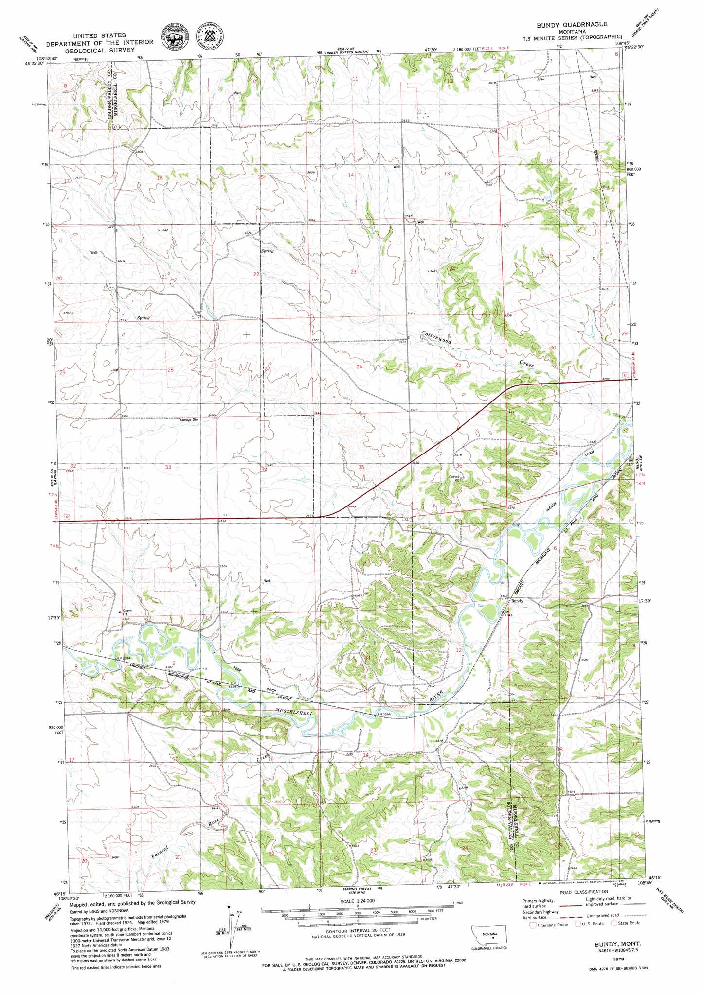
Bundy Topo Map Montana
To zoom in, hover over the map of Bundy
USGS Topo Quad 46108c7 - 1:24,000 scale
| Topo Map Name: | Bundy |
| USGS Topo Quad ID: | 46108c7 |
| Print Size: | ca. 21 1/4" wide x 27" high |
| Southeast Coordinates: | 46.25° N latitude / 108.75° W longitude |
| Map Center Coordinates: | 46.3125° N latitude / 108.8125° W longitude |
| U.S. State: | MT |
| Filename: | o46108c7.jpg |
| Download Map JPG Image: | Bundy topo map 1:24,000 scale |
| Map Type: | Topographic |
| Topo Series: | 7.5´ |
| Map Scale: | 1:24,000 |
| Source of Map Images: | United States Geological Survey (USGS) |
| Alternate Map Versions: |
Bundy MT 1979, updated 1979 Download PDF Buy paper map Bundy MT 2011 Download PDF Buy paper map Bundy MT 2014 Download PDF Buy paper map |
1:24,000 Topo Quads surrounding Bundy
Sahara Hill Se |
Emory School |
Timber Buttes North |
Lake Mason |
Lake Mason Se |
Cushman Ne |
Lavina Nw |
Timber Buttes South |
Horse Thief Creek |
Roundup |
Cushman |
Lavina |
Bundy |
Elso |
Harper Coulee |
Eagle Point |
Belmont |
Broadview Ne |
Hay Basin North |
Hay Basin Ne |
Hailstone Basin Se |
Broadview West |
Broadview East |
Hay Basin South |
North Fork Crooked Creek West |
> Back to 46108a1 at 1:100,000 scale
> Back to 46108a1 at 1:250,000 scale
> Back to U.S. Topo Maps home
Bundy topo map: Gazetteer
Bundy: Canals
Egge Ditch elevation 1030m 3379′Glennie Ditch elevation 1017m 3336′
Bundy: Populated Places
Bundy elevation 1019m 3343′Bundy: Post Offices
Bundy Post Office (historical) elevation 1019m 3343′Bundy: Streams
Painted Robe Creek elevation 1024m 3359′Bundy: Valleys
Cottonwood Creek elevation 1011m 3316′Bundy: Wells
06N22E02AC__01 Well elevation 1086m 3562′06N23E01CBDB01 Well elevation 1059m 3474′
06N23E02ACAD01 Well elevation 1066m 3497′
06N23E02CBAA01 Well elevation 1079m 3540′
06N24E06ADDD01 Well elevation 1066m 3497′
06N24E08C___01 Well elevation 1097m 3599′
06N24E18DCCD01 Well elevation 1101m 3612′
07N23E25BBCC01 Well elevation 1039m 3408′
07N23E27DBDC01 Well elevation 1061m 3480′
07N23E33AABA01 Well elevation 1073m 3520′
Bundy digital topo map on disk
Buy this Bundy topo map showing relief, roads, GPS coordinates and other geographical features, as a high-resolution digital map file on DVD: