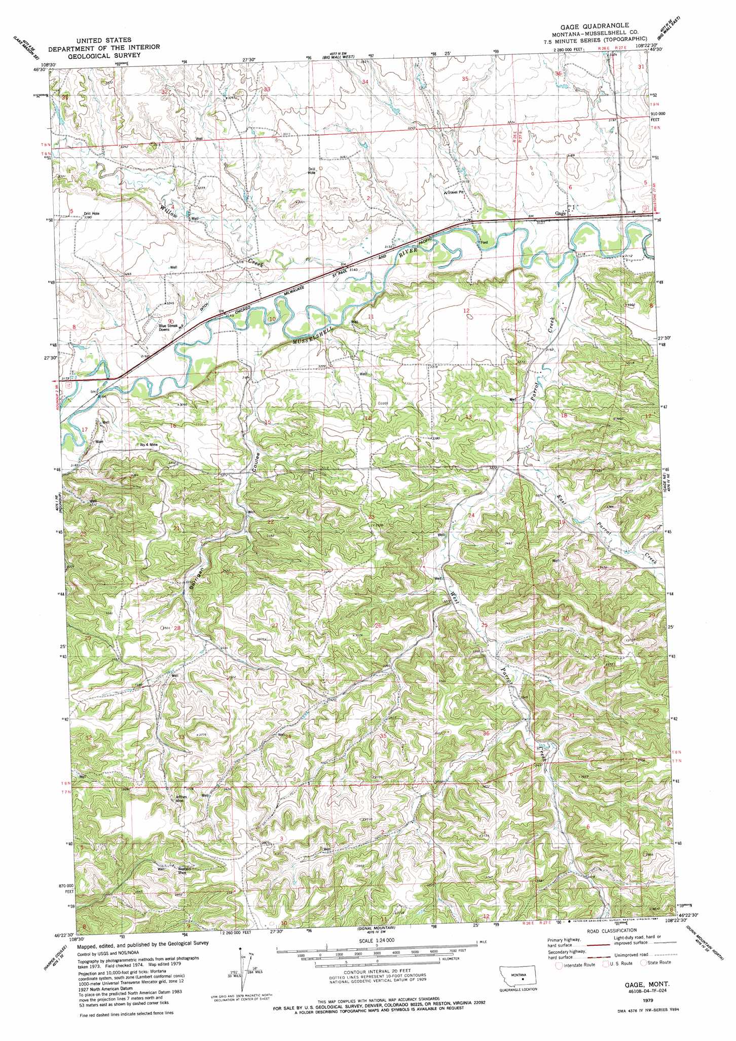
Gage Topo Map Montana
To zoom in, hover over the map of Gage
USGS Topo Quad 46108d4 - 1:24,000 scale
| Topo Map Name: | Gage |
| USGS Topo Quad ID: | 46108d4 |
| Print Size: | ca. 21 1/4" wide x 27" high |
| Southeast Coordinates: | 46.375° N latitude / 108.375° W longitude |
| Map Center Coordinates: | 46.4375° N latitude / 108.4375° W longitude |
| U.S. State: | MT |
| Filename: | o46108d4.jpg |
| Download Map JPG Image: | Gage topo map 1:24,000 scale |
| Map Type: | Topographic |
| Topo Series: | 7.5´ |
| Map Scale: | 1:24,000 |
| Source of Map Images: | United States Geological Survey (USGS) |
| Alternate Map Versions: |
Gage MT 1979, updated 1987 Download PDF Buy paper map Gage MT 2011 Download PDF Buy paper map Gage MT 2014 Download PDF Buy paper map |
1:24,000 Topo Quads surrounding Gage
Lake Mason Nw |
Lake Mason Ne |
Big Wall Nw |
Jim Coulee |
Musselshell Nw |
Lake Mason |
Lake Mason Se |
Big Wall West |
Big Wall East |
Delphia |
Horse Thief Creek |
Roundup |
Gage |
Gage Ne |
Chimney Butte |
Elso |
Harper Coulee |
Signal Mountain |
Dunn Mountain North |
Cherry Spring |
Hay Basin North |
Hay Basin Ne |
Park Coulee |
Dunn Mountain South |
P K Ranch |
> Back to 46108a1 at 1:100,000 scale
> Back to 46108a1 at 1:250,000 scale
> Back to U.S. Topo Maps home
Gage topo map: Gazetteer
Gage: Canals
N-F Ditch elevation 963m 3159′Gage: Mines
Jeffries Mine elevation 1110m 3641′Number 4 Mine elevation 995m 3264′
Western Mine elevation 1116m 3661′
Gage: Populated Places
Gage elevation 955m 3133′Gage: Post Offices
Gage Post Office (historical) elevation 955m 3133′Gage: Springs
08N26E25CA__01 Spring elevation 1035m 3395′08N26E26DCC_01 Spring elevation 1049m 3441′
08N26E28DB__01 Spring elevation 1051m 3448′
08N26E34AC__01 Spring elevation 1077m 3533′
08N26E34ADA_01 Spring elevation 1042m 3418′
08N26E35BBA_01 Spring elevation 1045m 3428′
08N27E29BCA_01 Spring elevation 1028m 3372′
08N27E32CDB_01 Spring elevation 1089m 3572′
Gage: Streams
East Parrot Creek elevation 975m 3198′Parrot Creek elevation 949m 3113′
West Parrot Creek elevation 975m 3198′
Willow Creek elevation 956m 3136′
Gage: Valleys
Barrigan Coulee elevation 965m 3166′Gage: Wells
07N26E02ADCB01 Well elevation 1065m 3494′07N26E03DADA01 Well elevation 1085m 3559′
07N26E03DBDA01 Well elevation 1102m 3615′
07N26E04AABC01 Well elevation 1108m 3635′
07N26E04CDBA01 Well elevation 1111m 3645′
07N27E06CBBB01 Well elevation 1053m 3454′
07N27E06CCB_01 Well elevation 1057m 3467′
07N27E06DCBC01 Well elevation 1065m 3494′
07N27E06DDDD01 Well elevation 1093m 3585′
08N26E10BBBB01 Well elevation 978m 3208′
08N26E25BACC01 Well elevation 1002m 3287′
08N26E25BBDA01 Well elevation 994m 3261′
08N26E25DB__01 Well elevation 1011m 3316′
08N26E26DBAD01 Well elevation 1016m 3333′
08N26E27BA__01 Well elevation 1023m 3356′
08N26E28CD__01 Well elevation 1056m 3464′
08N26E28CDCA01 Well elevation 1063m 3487′
08N26E32AAAA01 Well elevation 1071m 3513′
08N26E34ADB_01 Well elevation 1047m 3435′
08N26E34CAA_01 Well elevation 1068m 3503′
08N26E34DDC_01 Well elevation 1090m 3576′
08N27E31CCBD01 Well elevation 1031m 3382′
Gage digital topo map on disk
Buy this Gage topo map showing relief, roads, GPS coordinates and other geographical features, as a high-resolution digital map file on DVD: