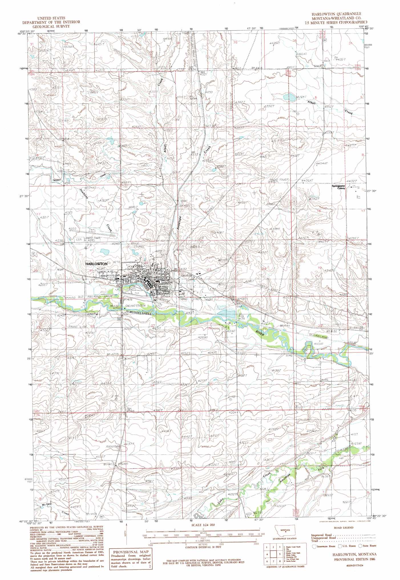
Harlowton Topo Map Montana
To zoom in, hover over the map of Harlowton
USGS Topo Quad 46109d7 - 1:24,000 scale
| Topo Map Name: | Harlowton |
| USGS Topo Quad ID: | 46109d7 |
| Print Size: | ca. 21 1/4" wide x 27" high |
| Southeast Coordinates: | 46.375° N latitude / 109.75° W longitude |
| Map Center Coordinates: | 46.4375° N latitude / 109.8125° W longitude |
| U.S. State: | MT |
| Filename: | o46109d7.jpg |
| Download Map JPG Image: | Harlowton topo map 1:24,000 scale |
| Map Type: | Topographic |
| Topo Series: | 7.5´ |
| Map Scale: | 1:24,000 |
| Source of Map Images: | United States Geological Survey (USGS) |
| Alternate Map Versions: |
Harlowton MT 1986, updated 1986 Download PDF Buy paper map Harlowton MT 2011 Download PDF Buy paper map Harlowton MT 2014 Download PDF Buy paper map |
1:24,000 Topo Quads surrounding Harlowton
Jellison Place |
Mead Creek |
Judith Gap |
Elephant Rocks |
Yaple Bench |
Haymaker Ranch |
Hopley Creek North |
Oka |
Oxford |
Nihill |
Twodot |
Hopley Creek South |
Harlowton |
Ethels Coulee |
Hedgesville |
Lebo Lake |
Harlowton Sw |
Ten O'Clock Gate |
Devils Pocket |
Shawmut |
Porcupine Butte |
Melville Nw |
Gougley Creek |
Jim Creek |
Progress |
> Back to 46109a1 at 1:100,000 scale
> Back to 46108a1 at 1:250,000 scale
> Back to U.S. Topo Maps home
Harlowton topo map: Gazetteer
Harlowton: Airports
Wheatland County Airport elevation 1316m 4317′Harlowton: Dams
Harlowton Sewage Lagoon Dam elevation 1282m 4206′Jawbone Dam Number 1 elevation 1302m 4271′
Jawbone Dam Number 2 elevation 1289m 4229′
Jawbone Dike Number 1 elevation 1280m 4199′
Harlowton: Parks
Chief Joseph Park elevation 1272m 4173′E57B - the Last Electric Locomotive Historical Marker elevation 1282m 4206′
Harlowton: Populated Places
Harlowton elevation 1282m 4206′Shepherds Trailer Court elevation 1282m 4206′
Springwater Colony elevation 1353m 4438′
Harlowton: Post Offices
Harlowton Post Office elevation 1280m 4199′Harlowton: Streams
Alkali Creek elevation 1290m 4232′Antelope Creek elevation 1265m 4150′
Jawbone Creek elevation 1264m 4146′
Lebo Creek elevation 1276m 4186′
Harlowton: Wells
08N15E10____01 Well elevation 1320m 4330′08N15E12ABDB01 Well elevation 1318m 4324′
08N15E20____01 Well elevation 1286m 4219′
08N15E21C___01 Well elevation 1278m 4192′
08N15E22____01 Well elevation 1289m 4229′
08N15E22CDA_01 Well elevation 1271m 4169′
08N15E23AAAA01 Well elevation 1339m 4393′
08N15E23C___01 Well elevation 1270m 4166′
08N15E26AAAD01 Well elevation 1263m 4143′
08N15E27A___01 Well elevation 1269m 4163′
08N15E27B___01 Well elevation 1274m 4179′
08N15E34____01 Well elevation 1313m 4307′
08N15E35B___01 Well elevation 1312m 4304′
Harlowton digital topo map on disk
Buy this Harlowton topo map showing relief, roads, GPS coordinates and other geographical features, as a high-resolution digital map file on DVD: