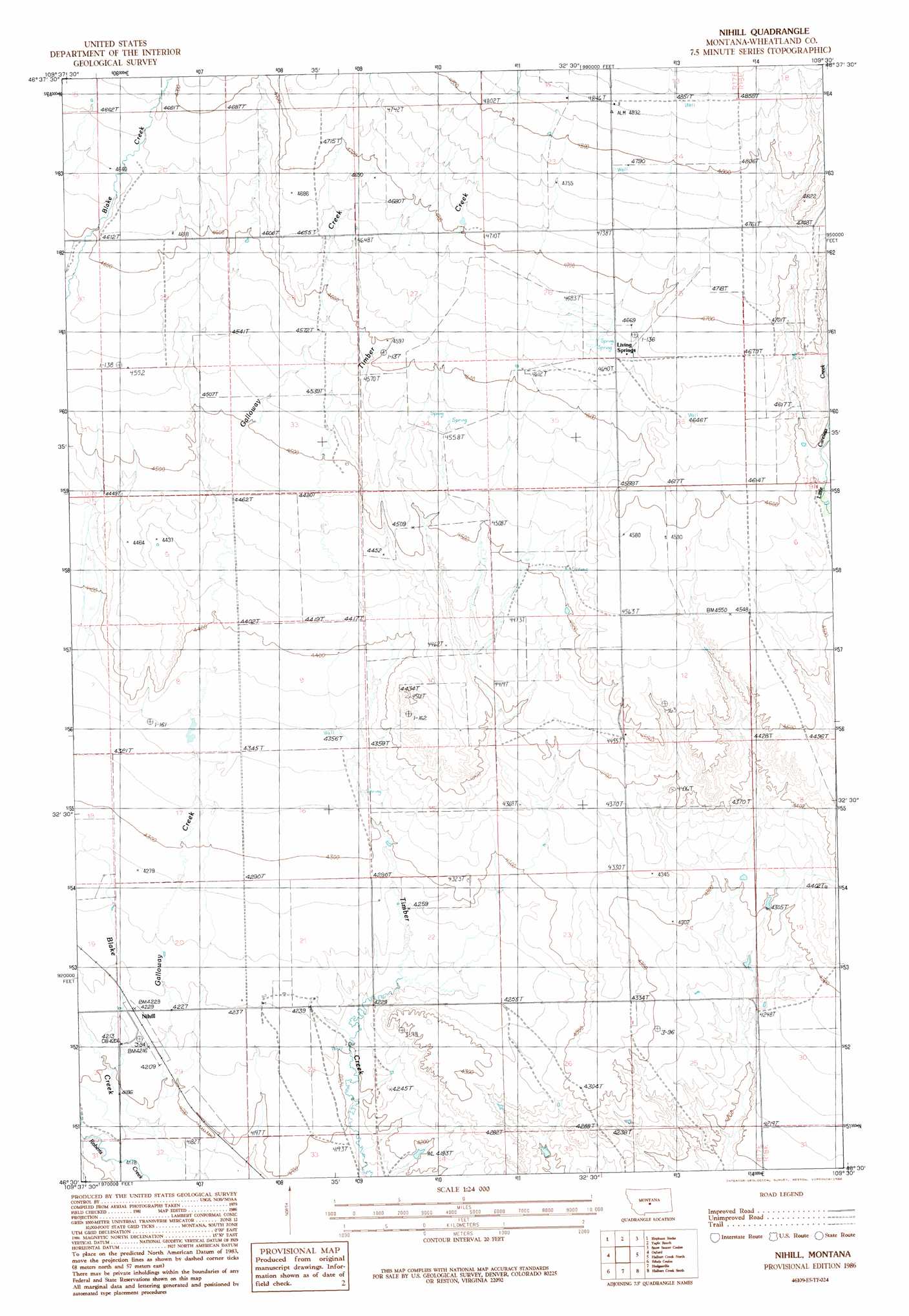
Nihill Topo Map Montana
To zoom in, hover over the map of Nihill
USGS Topo Quad 46109e5 - 1:24,000 scale
| Topo Map Name: | Nihill |
| USGS Topo Quad ID: | 46109e5 |
| Print Size: | ca. 21 1/4" wide x 27" high |
| Southeast Coordinates: | 46.5° N latitude / 109.5° W longitude |
| Map Center Coordinates: | 46.5625° N latitude / 109.5625° W longitude |
| U.S. State: | MT |
| Filename: | o46109e5.jpg |
| Download Map JPG Image: | Nihill topo map 1:24,000 scale |
| Map Type: | Topographic |
| Topo Series: | 7.5´ |
| Map Scale: | 1:24,000 |
| Source of Map Images: | United States Geological Survey (USGS) |
| Alternate Map Versions: |
Nihill MT 1986, updated 1986 Download PDF Buy paper map Nihill MT 2011 Download PDF Buy paper map Nihill MT 2014 Download PDF Buy paper map |
1:24,000 Topo Quads surrounding Nihill
Buffalo |
Moore Sw |
Crystal Lake |
Jump Off Peak |
Half Moon Canyon |
Judith Gap |
Elephant Rocks |
Yaple Bench |
Snow Saucer Coulee |
Green Ashly Gulch |
Oka |
Oxford |
Nihill |
Halbert Creek North |
Rothiemay |
Harlowton |
Ethels Coulee |
Hedgesville |
Halbert Creek South |
Vallum |
Ten O'Clock Gate |
Devils Pocket |
Shawmut |
Deadman Basin Res. |
Ryegate West |
> Back to 46109e1 at 1:100,000 scale
> Back to 46108a1 at 1:250,000 scale
> Back to U.S. Topo Maps home
Nihill topo map: Gazetteer
Nihill: Populated Places
Living Springs elevation 1416m 4645′Nihill: Post Offices
Living Springs Post Office (historical) elevation 1416m 4645′Nihill Post Office (historical) elevation 1288m 4225′
Nihill: Streams
Galloway Creek elevation 1272m 4173′Timber Creek elevation 1289m 4229′
West Galloway Creek elevation 1359m 4458′
Nihill: Wells
09N17E13B___01 Well elevation 1341m 4399′09N17E21C___01 Well elevation 1297m 4255′
10N17E24B___01 Well elevation 1468m 4816′
10N17E25C___01 Well elevation 1428m 4685′
10N17E36B___01 Well elevation 1415m 4642′
Nihill digital topo map on disk
Buy this Nihill topo map showing relief, roads, GPS coordinates and other geographical features, as a high-resolution digital map file on DVD: