Green Ashly Gulch Topo Map Montana
To zoom in, hover over the map of Green Ashly Gulch
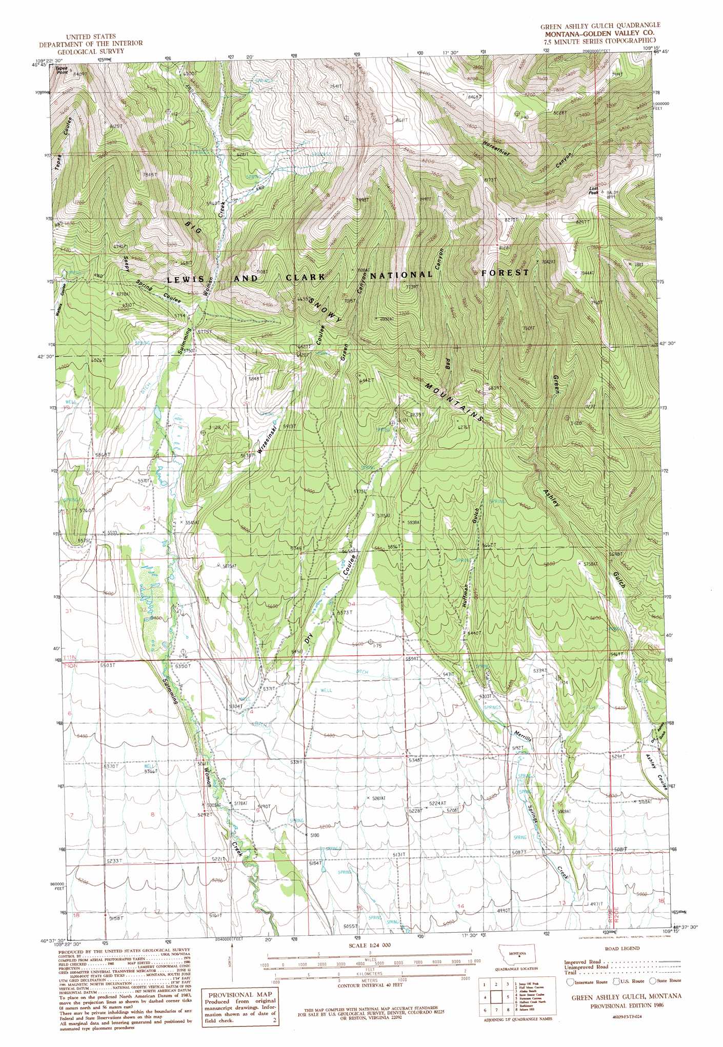
USGS Topo Quad 46109f3 - 1:24,000 scale
| Topo Map Name: | Green Ashly Gulch |
| USGS Topo Quad ID: | 46109f3 |
| Print Size: | ca. 21 1/4" wide x 27" high |
| Southeast Coordinates: | 46.625° N latitude / 109.25° W longitude |
| Map Center Coordinates: | 46.6875° N latitude / 109.3125° W longitude |
| U.S. State: | MT |
| Filename: | o46109f3.jpg |
| Download Map JPG Image: | Green Ashly Gulch topo map 1:24,000 scale |
| Map Type: | Topographic |
| Topo Series: | 7.5´ |
| Map Scale: | 1:24,000 |
| Source of Map Images: | United States Geological Survey (USGS) |
| Alternate Map Versions: |
Green Ashley Gulch MT 1986, updated 1988 Download PDF Buy paper map Green Ashley Gulch MT 1995, updated 1997 Download PDF Buy paper map Green Ashly Gulch MT 2011 Download PDF Buy paper map Green Ashly Gulch MT 2014 Download PDF Buy paper map |
| FStopo: | US Forest Service topo Green Ashly Gulch is available: Download FStopo PDF Download FStopo TIF |
1:24,000 Topo Quads surrounding Green Ashly Gulch
West Fork Beaver Creek |
Castle Butte |
Heath |
Loco Ridge |
Forestgrove |
Crystal Lake |
Jump Off Peak |
Half Moon Canyon |
Alaska Bench |
South Bench |
Yaple Bench |
Snow Saucer Coulee |
Green Ashly Gulch |
Patterson Canyon |
Sahara Hill |
Nihill |
Halbert Creek North |
Rothiemay |
Sahara Hill Sw |
Sahara Hill Se |
Hedgesville |
Halbert Creek South |
Vallum |
Cushman Nw |
Cushman Ne |
> Back to 46109e1 at 1:100,000 scale
> Back to 46108a1 at 1:250,000 scale
> Back to U.S. Topo Maps home
Green Ashly Gulch topo map: Gazetteer
Green Ashly Gulch: Post Offices
Irene Post Office (historical) elevation 1585m 5200′Whelan Post Office (historical) elevation 1622m 5321′
Green Ashly Gulch: Streams
Seepy Spring Coulee elevation 1768m 5800′Green Ashly Gulch: Summits
Lost Peak elevation 2497m 8192′Tepee Point elevation 2560m 8398′
Green Ashly Gulch: Valleys
Bad Canyon elevation 1775m 5823′Dry Ashley Gulch elevation 1582m 5190′
Dry Coulee elevation 1626m 5334′
Green Ashley Gulch elevation 1581m 5187′
Green Canyon elevation 1757m 5764′
Huffman Gulch elevation 1637m 5370′
Wrzesinski Coulee elevation 1684m 5524′
Green Ashly Gulch digital topo map on disk
Buy this Green Ashly Gulch topo map showing relief, roads, GPS coordinates and other geographical features, as a high-resolution digital map file on DVD: