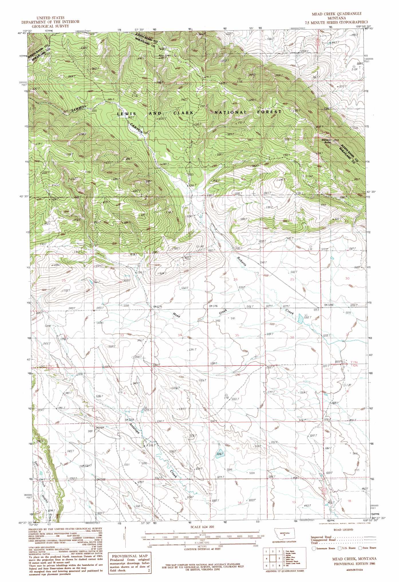
Mead Creek Topo Map Montana
To zoom in, hover over the map of Mead Creek
USGS Topo Quad 46109f8 - 1:24,000 scale
| Topo Map Name: | Mead Creek |
| USGS Topo Quad ID: | 46109f8 |
| Print Size: | ca. 21 1/4" wide x 27" high |
| Southeast Coordinates: | 46.625° N latitude / 109.875° W longitude |
| Map Center Coordinates: | 46.6875° N latitude / 109.9375° W longitude |
| U.S. State: | MT |
| Filename: | o46109f8.jpg |
| Download Map JPG Image: | Mead Creek topo map 1:24,000 scale |
| Map Type: | Topographic |
| Topo Series: | 7.5´ |
| Map Scale: | 1:24,000 |
| Source of Map Images: | United States Geological Survey (USGS) |
| Alternate Map Versions: |
Mead Creek MT 1986, updated 1986 Download PDF Buy paper map Mead Creek MT 1995, updated 1997 Download PDF Buy paper map Mead Creek MT 2011 Download PDF Buy paper map Mead Creek MT 2014 Download PDF Buy paper map |
| FStopo: | US Forest Service topo Mead Creek is available: Download FStopo PDF Download FStopo TIF |
1:24,000 Topo Quads surrounding Mead Creek
Red Hill |
Utica |
Ackley Lake |
Sipple |
Moore |
Browns Canyon |
Twin Sisters |
Martin Coulee |
Buffalo |
Moore Sw |
Haymaker Narrows |
Jellison Place |
Mead Creek |
Judith Gap |
Elephant Rocks |
Haymaker Ranch Sw |
Haymaker Ranch |
Hopley Creek North |
Oka |
Oxford |
Twodot Nw |
Twodot |
Hopley Creek South |
Harlowton |
Ethels Coulee |
> Back to 46109e1 at 1:100,000 scale
> Back to 46108a1 at 1:250,000 scale
> Back to U.S. Topo Maps home
Mead Creek topo map: Gazetteer
Mead Creek: Springs
11N14E01AD__01 Spring elevation 1602m 5255′11N14E01AD__02 Spring elevation 1602m 5255′
11N14E01BB__01 Spring elevation 1548m 5078′
11N14E02AA__01 Spring elevation 1547m 5075′
Mead Creek: Streams
Mead Creek elevation 1549m 5082′Mead Creek: Summits
Stevens Butte elevation 1994m 6541′Mead Creek: Valleys
Sawmill Canyon elevation 1699m 5574′Mead Creek: Wells
10N15E06B___01 Well elevation 1525m 5003′11N14E34DCA_01 Well elevation 1619m 5311′
11N15E31C___01 Well elevation 1527m 5009′
Mead Creek digital topo map on disk
Buy this Mead Creek topo map showing relief, roads, GPS coordinates and other geographical features, as a high-resolution digital map file on DVD: