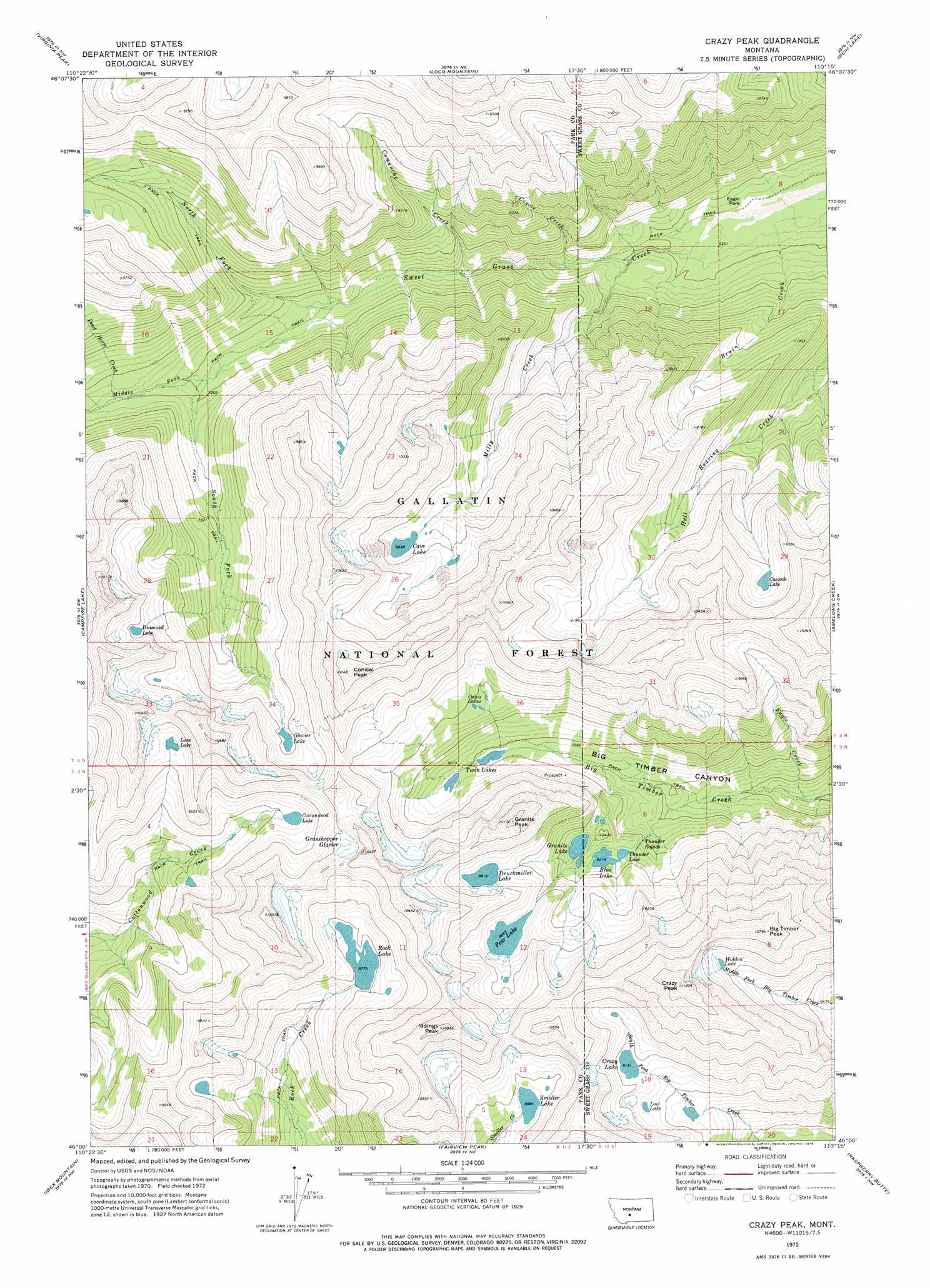
Crazy Peak Topo Map Montana
To zoom in, hover over the map of Crazy Peak
USGS Topo Quad 46110a3 - 1:24,000 scale
| Topo Map Name: | Crazy Peak |
| USGS Topo Quad ID: | 46110a3 |
| Print Size: | ca. 21 1/4" wide x 27" high |
| Southeast Coordinates: | 46° N latitude / 110.25° W longitude |
| Map Center Coordinates: | 46.0625° N latitude / 110.3125° W longitude |
| U.S. State: | MT |
| Filename: | o46110a3.jpg |
| Download Map JPG Image: | Crazy Peak topo map 1:24,000 scale |
| Map Type: | Topographic |
| Topo Series: | 7.5´ |
| Map Scale: | 1:24,000 |
| Source of Map Images: | United States Geological Survey (USGS) |
| Alternate Map Versions: |
Crazy Peak MT 1972, updated 1976 Download PDF Buy paper map Crazy Peak MT 1972, updated 1976 Download PDF Buy paper map Crazy Peak MT 2000, updated 2005 Download PDF Buy paper map Crazy Peak MT 2011 Download PDF Buy paper map Crazy Peak MT 2014 Download PDF Buy paper map |
| FStopo: | US Forest Service topo Crazy Peak is available: Download FStopo PDF Download FStopo TIF |
1:24,000 Topo Quads surrounding Crazy Peak
Rimrock Divide |
Lebo |
Cinnamon Peak |
Cinnamon Spring |
Lebo Lake |
Scab Rock Mountain |
Virginia Peak |
Loco Mountain |
Rein Lake |
Porcupine Butte |
Lena Creek |
Campfire Lake |
Crazy Peak |
Amelong Creek |
Battleship Butte |
Clyde Park |
Ibex Mountain |
Fairview Peak |
Raspberry Butte |
Grosfield Ranch |
Chadborn |
Grannis |
Hunters Hot Springs |
Kelly Hills |
Carney |
> Back to 46110a1 at 1:100,000 scale
> Back to 46110a1 at 1:250,000 scale
> Back to U.S. Topo Maps home
Crazy Peak topo map: Gazetteer
Crazy Peak: Glaciers
Grasshopper Glacier elevation 2946m 9665′Crazy Peak: Lakes
Blue Lake elevation 2506m 8221′Cascade Lake elevation 2696m 8845′
Cave Lake elevation 2634m 8641′
Cottonwood Lake elevation 2696m 8845′
Crazy Lake elevation 2785m 9137′
Diamond Lake elevation 2797m 9176′
Druckmiller Lake elevation 2719m 8920′
Glacier Lake elevation 2671m 8763′
Granite Lake elevation 2501m 8205′
Hidden Lake elevation 2942m 9652′
Lone Lake elevation 2845m 9333′
Lost Lake elevation 2728m 8950′
Oasis Lakes elevation 2672m 8766′
Pear Lake elevation 2699m 8854′
Smeller Lake elevation 2770m 9087′
Thunder Lake elevation 2457m 8061′
Twin Lakes elevation 2428m 7965′
Crazy Peak: Mines
Granite Mountain Mine elevation 2612m 8569′Granite Mountain Shaft elevation 2792m 9160′
Stemwinder Mine elevation 2460m 8070′
Upper Stemwinder Mine elevation 2705m 8874′
Crazy Peak: Parks
Eagle Park elevation 1893m 6210′Crazy Peak: Rapids
Thunder Rapids elevation 2457m 8061′Crazy Peak: Reservoirs
Rock Lake elevation 2661m 8730′Crazy Peak: Streams
Comanche Creek elevation 2073m 6801′Coyote Creek elevation 2003m 6571′
Dead Horse Creek elevation 2258m 7408′
Eagle Creek elevation 2089m 6853′
Middle Fork Sweet Grass Creek elevation 2179m 7148′
Milly Creek elevation 1950m 6397′
North Fork Sweet Grass Creek elevation 2127m 6978′
South Fork Sweet Grass Creek elevation 2131m 6991′
Crazy Peak: Summits
Big Timber Peak elevation 3281m 10764′Conical Peak elevation 3262m 10702′
Crazy Peak elevation 3407m 11177′
Granite Peak elevation 3079m 10101′
Iddings Peak elevation 3334m 10938′
Wilsall Peak elevation 3195m 10482′
Crazy Peak digital topo map on disk
Buy this Crazy Peak topo map showing relief, roads, GPS coordinates and other geographical features, as a high-resolution digital map file on DVD: