Cinnamon Spring Topo Map Montana
To zoom in, hover over the map of Cinnamon Spring
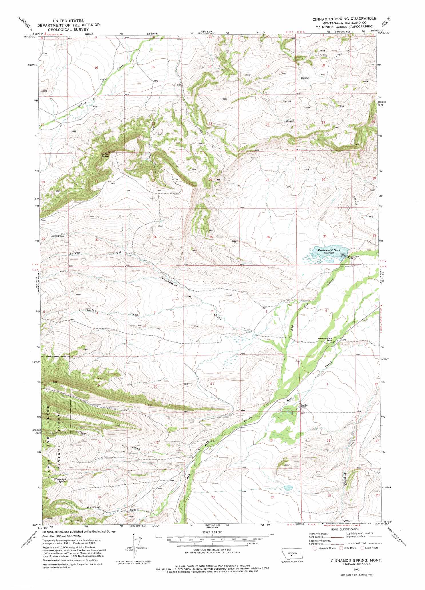
USGS Topo Quad 46110c2 - 1:24,000 scale
| Topo Map Name: | Cinnamon Spring |
| USGS Topo Quad ID: | 46110c2 |
| Print Size: | ca. 21 1/4" wide x 27" high |
| Southeast Coordinates: | 46.25° N latitude / 110.125° W longitude |
| Map Center Coordinates: | 46.3125° N latitude / 110.1875° W longitude |
| U.S. State: | MT |
| Filename: | o46110c2.jpg |
| Download Map JPG Image: | Cinnamon Spring topo map 1:24,000 scale |
| Map Type: | Topographic |
| Topo Series: | 7.5´ |
| Map Scale: | 1:24,000 |
| Source of Map Images: | United States Geological Survey (USGS) |
| Alternate Map Versions: |
Cinnamon Spring MT 1972, updated 1976 Download PDF Buy paper map Cinnamon Spring MT 1995, updated 1997 Download PDF Buy paper map Cinnamon Spring MT 2011 Download PDF Buy paper map Cinnamon Spring MT 2014 Download PDF Buy paper map |
| FStopo: | US Forest Service topo Cinnamon Spring is available: Download FStopo PDF Download FStopo TIF |
1:24,000 Topo Quads surrounding Cinnamon Spring
Mount Howe |
Mud Creek |
Haymaker Ranch Sw |
Haymaker Ranch |
Hopley Creek North |
Groveland |
Martinsdale |
Twodot Nw |
Twodot |
Hopley Creek South |
Lebo |
Cinnamon Peak |
Cinnamon Spring |
Lebo Lake |
Harlowton Sw |
Virginia Peak |
Loco Mountain |
Rein Lake |
Porcupine Butte |
Melville Nw |
Campfire Lake |
Crazy Peak |
Amelong Creek |
Battleship Butte |
Melville |
> Back to 46110a1 at 1:100,000 scale
> Back to 46110a1 at 1:250,000 scale
> Back to U.S. Topo Maps home
Cinnamon Spring topo map: Gazetteer
Cinnamon Spring: Dams
Big Elk Dam elevation 1592m 5223′White Elk Dam elevation 1727m 5666′
Cinnamon Spring: Reservoirs
Martin and C Bar J Reservoir elevation 1592m 5223′Cinnamon Spring: Ridges
Jack Arthur Ridge elevation 1878m 6161′Cinnamon Spring: Springs
Cinnamon Spring elevation 1915m 6282′Cinnamon Spring: Streams
Buzzard Creek elevation 1732m 5682′Cinnamon Creek elevation 1612m 5288′
Spring Creek elevation 1675m 5495′
Station Creek elevation 1650m 5413′
Willow Creek elevation 1726m 5662′
Cinnamon Spring: Summits
Coffin Butte elevation 1903m 6243′Cinnamon Spring: Wells
06N13E05C___01 Well elevation 1626m 5334′Cinnamon Spring digital topo map on disk
Buy this Cinnamon Spring topo map showing relief, roads, GPS coordinates and other geographical features, as a high-resolution digital map file on DVD: