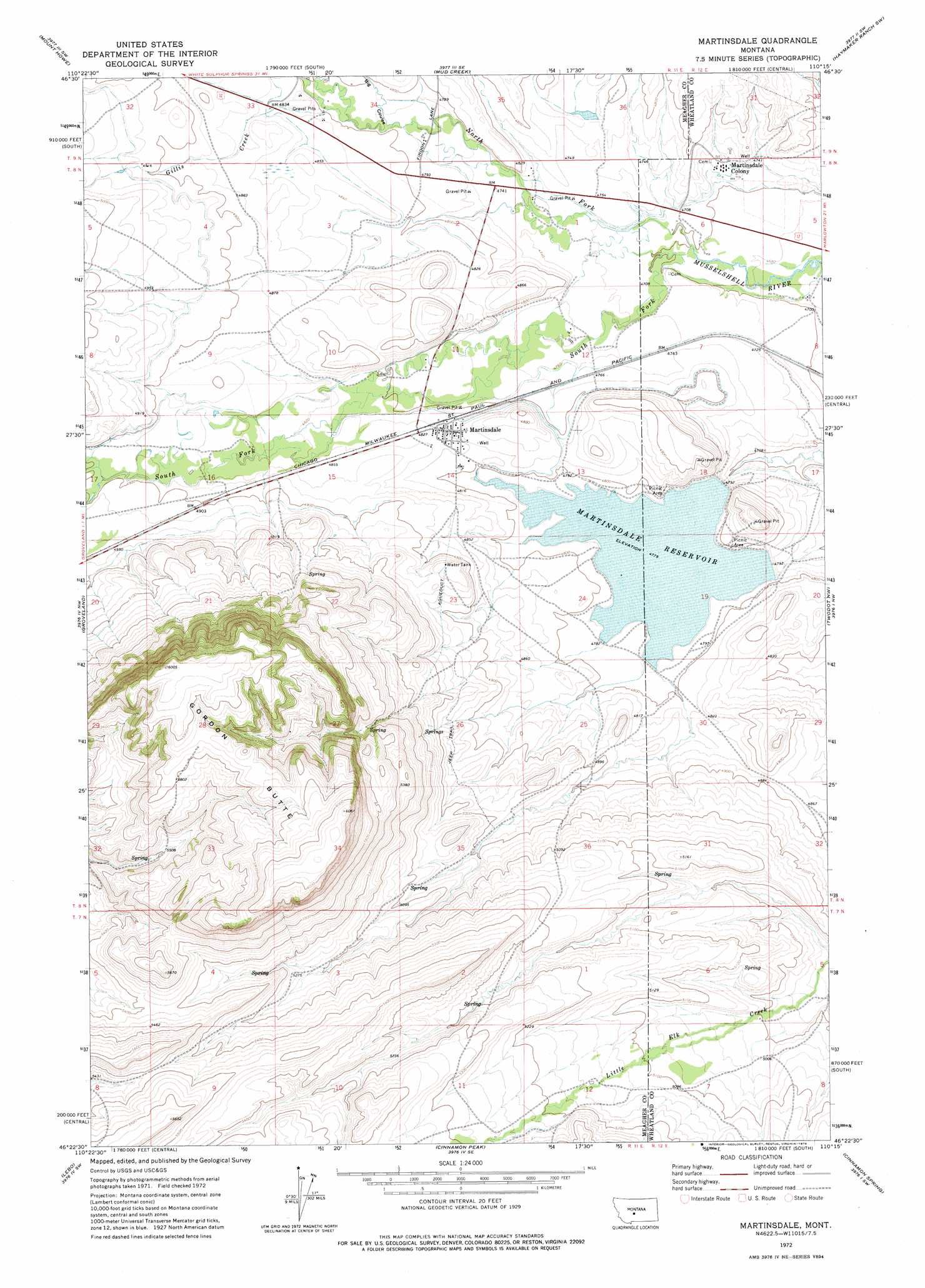
Martinsdale Topo Map Montana
To zoom in, hover over the map of Martinsdale
USGS Topo Quad 46110d3 - 1:24,000 scale
| Topo Map Name: | Martinsdale |
| USGS Topo Quad ID: | 46110d3 |
| Print Size: | ca. 21 1/4" wide x 27" high |
| Southeast Coordinates: | 46.375° N latitude / 110.25° W longitude |
| Map Center Coordinates: | 46.4375° N latitude / 110.3125° W longitude |
| U.S. State: | MT |
| Filename: | o46110d3.jpg |
| Download Map JPG Image: | Martinsdale topo map 1:24,000 scale |
| Map Type: | Topographic |
| Topo Series: | 7.5´ |
| Map Scale: | 1:24,000 |
| Source of Map Images: | United States Geological Survey (USGS) |
| Alternate Map Versions: |
Martinsdale MT 1972, updated 1976 Download PDF Buy paper map Martinsdale MT 2011 Download PDF Buy paper map Martinsdale MT 2014 Download PDF Buy paper map |
1:24,000 Topo Quads surrounding Martinsdale
Hoover Spring |
Russian Flat |
Daisy Peak |
Haymaker Narrows |
Jellison Place |
Checkerboard |
Mount Howe |
Mud Creek |
Haymaker Ranch Sw |
Haymaker Ranch |
Lennep |
Groveland |
Martinsdale |
Twodot Nw |
Twodot |
Rimrock Divide |
Lebo |
Cinnamon Peak |
Cinnamon Spring |
Lebo Lake |
Scab Rock Mountain |
Virginia Peak |
Loco Mountain |
Rein Lake |
Porcupine Butte |
> Back to 46110a1 at 1:100,000 scale
> Back to 46110a1 at 1:250,000 scale
> Back to U.S. Topo Maps home
Martinsdale topo map: Gazetteer
Martinsdale: Dams
East Martinsdale Dam elevation 1448m 4750′North Martinsdale Dam elevation 1452m 4763′
Third Stooges Dam elevation 1440m 4724′
Martinsdale: Populated Places
Gauglersville (historical) elevation 1451m 4760′Martinsdale elevation 1469m 4819′
Martinsdale Colony elevation 1446m 4744′
Martinsdale: Post Offices
Martinsdale Post Office elevation 1469m 4819′Martinsdale: Reservoirs
Martinsdale Reservoir elevation 1458m 4783′Martinsdale: Streams
Gillis Creek elevation 1463m 4799′North Fork Musselshell River elevation 1434m 4704′
South Fork Musselshell River elevation 1433m 4701′
Martinsdale: Summits
Gordon Butte elevation 1744m 5721′Martinsdale: Valleys
Big Coulee elevation 1456m 4776′Martinsdale: Wells
08N11E11____01 Well elevation 1458m 4783′08N11E14____01 Well elevation 1465m 4806′
08N11E14D___01 Well elevation 1473m 4832′
09N11E34C___01 Well elevation 1465m 4806′
Martinsdale digital topo map on disk
Buy this Martinsdale topo map showing relief, roads, GPS coordinates and other geographical features, as a high-resolution digital map file on DVD: