Lennep Topo Map Montana
To zoom in, hover over the map of Lennep
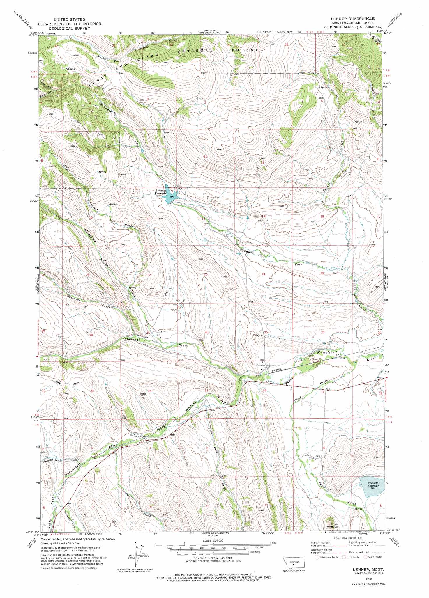
USGS Topo Quad 46110d5 - 1:24,000 scale
| Topo Map Name: | Lennep |
| USGS Topo Quad ID: | 46110d5 |
| Print Size: | ca. 21 1/4" wide x 27" high |
| Southeast Coordinates: | 46.375° N latitude / 110.5° W longitude |
| Map Center Coordinates: | 46.4375° N latitude / 110.5625° W longitude |
| U.S. State: | MT |
| Filename: | o46110d5.jpg |
| Download Map JPG Image: | Lennep topo map 1:24,000 scale |
| Map Type: | Topographic |
| Topo Series: | 7.5´ |
| Map Scale: | 1:24,000 |
| Source of Map Images: | United States Geological Survey (USGS) |
| Alternate Map Versions: |
Lennep MT 1972, updated 1976 Download PDF Buy paper map Lennep MT 1995, updated 1997 Download PDF Buy paper map Lennep MT 2011 Download PDF Buy paper map Lennep MT 2014 Download PDF Buy paper map |
| FStopo: | US Forest Service topo Lennep is available: Download FStopo PDF Download FStopo TIF |
1:24,000 Topo Quads surrounding Lennep
Charcoal Gulch |
Volcano Butte |
Hoover Spring |
Russian Flat |
Daisy Peak |
Pinchout Creek |
Fourmile Spring |
Checkerboard |
Mount Howe |
Mud Creek |
Manger Park |
Castle Town |
Lennep |
Groveland |
Martinsdale |
Ringling |
Hamen |
Rimrock Divide |
Lebo |
Cinnamon Peak |
Sixteen Ne |
Wolf Hill |
Scab Rock Mountain |
Virginia Peak |
Loco Mountain |
> Back to 46110a1 at 1:100,000 scale
> Back to 46110a1 at 1:250,000 scale
> Back to U.S. Topo Maps home
Lennep topo map: Gazetteer
Lennep: Dams
Bonanza Dam elevation 1699m 5574′Voldseth West Dam elevation 1677m 5501′
Lennep: Populated Places
Lennep elevation 1597m 5239′Lennep: Post Offices
Lennep Post Office (historical) elevation 1597m 5239′Lennep: Reservoirs
Bonanza Reservoir elevation 1699m 5574′Voldseth Reservoir elevation 1677m 5501′
Lennep: Streams
Alabaugh Creek elevation 1600m 5249′Bonanza Creek elevation 1598m 5242′
Bozeman Fork Musselshell River elevation 1663m 5456′
Comb Creek elevation 1574m 5164′
Corral Creek elevation 1672m 5485′
Coyote Creek elevation 1598m 5242′
Deer Creek elevation 1617m 5305′
North Fork Bonanza Creek elevation 1882m 6174′
Robinson Creek elevation 1642m 5387′
Sawmill Creek elevation 1645m 5396′
Slaughter House Creek elevation 1626m 5334′
South Fork Bonanza Creek elevation 1882m 6174′
Lennep: Summits
Comb Butte elevation 1808m 5931′Lennep: Wells
08N10E32____01 Well elevation 1600m 5249′Lennep digital topo map on disk
Buy this Lennep topo map showing relief, roads, GPS coordinates and other geographical features, as a high-resolution digital map file on DVD: