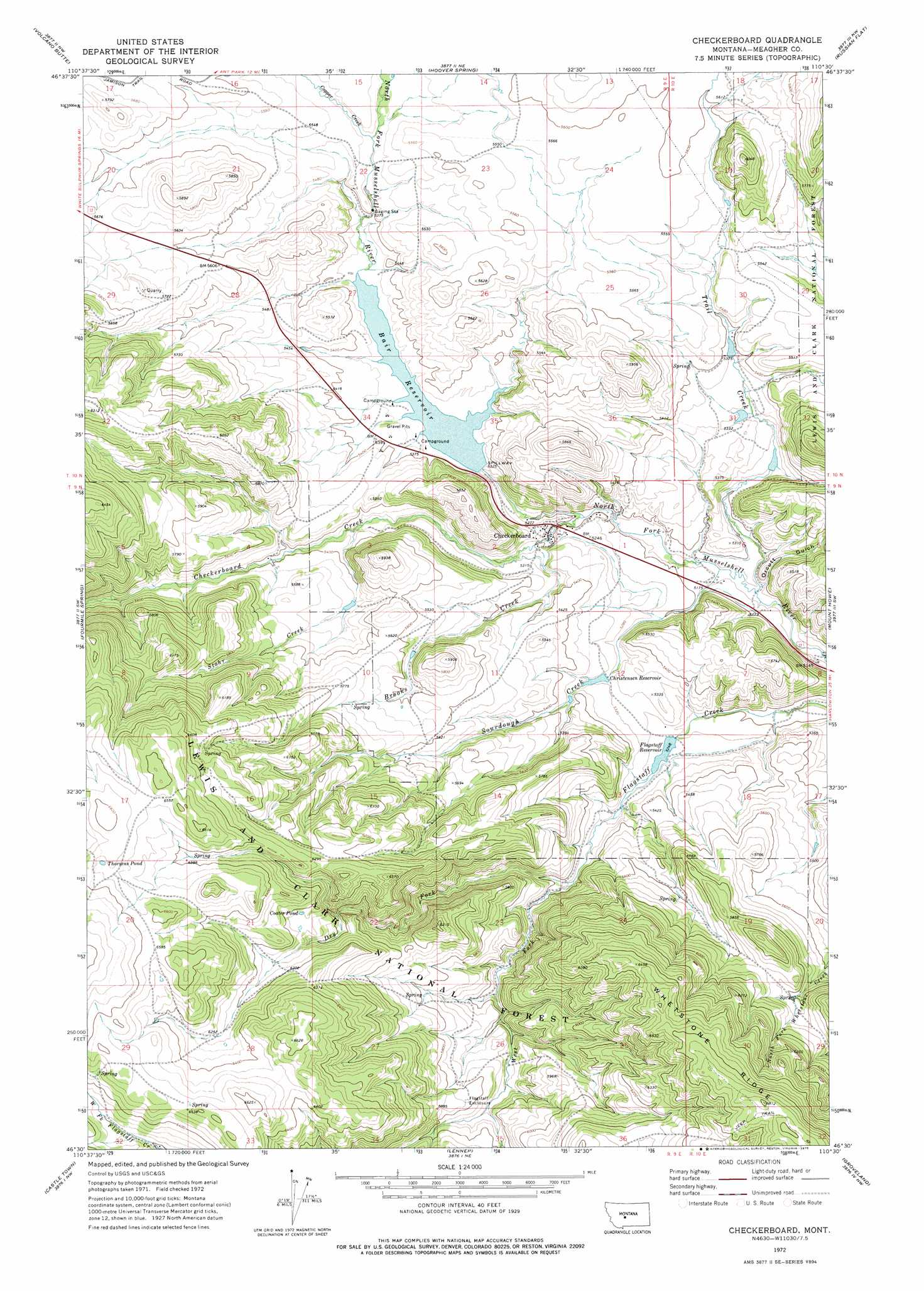
Checkerboard Topo Map Montana
To zoom in, hover over the map of Checkerboard
USGS Topo Quad 46110e5 - 1:24,000 scale
| Topo Map Name: | Checkerboard |
| USGS Topo Quad ID: | 46110e5 |
| Print Size: | ca. 21 1/4" wide x 27" high |
| Southeast Coordinates: | 46.5° N latitude / 110.5° W longitude |
| Map Center Coordinates: | 46.5625° N latitude / 110.5625° W longitude |
| U.S. State: | MT |
| Filename: | o46110e5.jpg |
| Download Map JPG Image: | Checkerboard topo map 1:24,000 scale |
| Map Type: | Topographic |
| Topo Series: | 7.5´ |
| Map Scale: | 1:24,000 |
| Source of Map Images: | United States Geological Survey (USGS) |
| Alternate Map Versions: |
Checkerboard MT 1972, updated 1975 Download PDF Buy paper map Checkerboard MT 1995, updated 1997 Download PDF Buy paper map Checkerboard MT 2011 Download PDF Buy paper map Checkerboard MT 2014 Download PDF Buy paper map |
| FStopo: | US Forest Service topo Checkerboard is available: Download FStopo PDF Download FStopo TIF |
1:24,000 Topo Quads surrounding Checkerboard
Moose Mountain |
Kings Hill |
Sand Point |
Ettien Spring |
Indian Hill |
Charcoal Gulch |
Volcano Butte |
Hoover Spring |
Russian Flat |
Daisy Peak |
Pinchout Creek |
Fourmile Spring |
Checkerboard |
Mount Howe |
Mud Creek |
Manger Park |
Castle Town |
Lennep |
Groveland |
Martinsdale |
Ringling |
Hamen |
Rimrock Divide |
Lebo |
Cinnamon Peak |
> Back to 46110e1 at 1:100,000 scale
> Back to 46110a1 at 1:250,000 scale
> Back to U.S. Topo Maps home
Checkerboard topo map: Gazetteer
Checkerboard: Dams
Bair Dam elevation 1638m 5374′Christensen Number 1 Dam elevation 1598m 5242′
Christensen Number 2 Dam elevation 1613m 5291′
Holliday Dam elevation 1601m 5252′
Checkerboard: Lakes
Coates Pond elevation 1876m 6154′Thorsens Pond elevation 2000m 6561′
Checkerboard: Mines
Copperopolis Mine elevation 1745m 5725′SW SW Section 27 Mine elevation 1657m 5436′
Checkerboard: Populated Places
Checkerboard elevation 1599m 5246′Checkerboard: Post Offices
Delpine Post Office (historical) elevation 1581m 5187′Checkerboard: Reservoirs
Bair Reservoir elevation 1624m 5328′Christensen Reservoir elevation 1621m 5318′
Flagstaff Reservoir elevation 1600m 5249′
Checkerboard: Ridges
Whetstone Ridge elevation 2072m 6797′Checkerboard: Streams
Brooks Creek elevation 1592m 5223′Checkerboard Creek elevation 1580m 5183′
Copper Creek elevation 1662m 5452′
Dry Fork elevation 1631m 5351′
Sourdough Creek elevation 1568m 5144′
Stohr Creek elevation 1625m 5331′
Trail Creek elevation 1563m 5127′
West Fork Flagstaff Creek elevation 1631m 5351′
Checkerboard: Valleys
Orcutt Gulch elevation 1570m 5150′Checkerboard: Wells
09N09E02____01 Well elevation 1679m 5508′Checkerboard digital topo map on disk
Buy this Checkerboard topo map showing relief, roads, GPS coordinates and other geographical features, as a high-resolution digital map file on DVD: